

Midday Nowcast: Hot and Dry Final Day of August
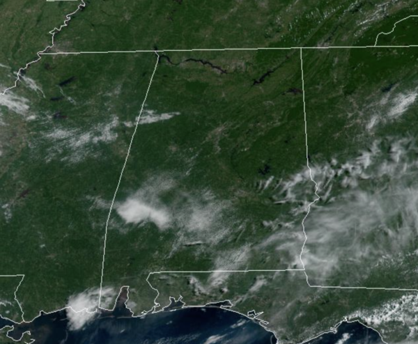
Drier air is settling into Alabama today, and that will keep today and tomorrow dry and hot, with abundant sunshine for most of Alabama. Highs these days will be in the low 90s. Tonight will be almost comfortable with lows in the 60s areawide. Moisture levels begin to increase some Friday and we will bring back the chance for a few showers and storm during the afternoon and evening hours.
SPACE WEATHER: A Big CME is about to hit Venus: A coronal mass ejection (CME) left the far side of the sun yesterday. According to NASA forecast models, it will slam into Venus on Sept. 1st, scouring some atmosphere from the planet’s cloudtops. Coincidentally, the European Space Agency’s Solar Orbiter spacecraft is passing by Venus right now, so it could get great data on this event.
LABOR DAY WEEKEND: For the long holiday weekend, we are forecasting partly sunny days, fair nights, with scattered to numerous showers and storms storms each day on occasion. No weekend washout, and no way of knowing in advance exactly when and where they form in advance, you just have to watch radar trends. Definitely have some indoor plans at times as you are likely to be dodging rain at some point. The chance of any one spot getting wet daily is 60-70%, and most of the showers will come in the noon to midnight window. Afternoon highs Saturday through Monday will be in the mid to upper 80s.
FOOTBALL WEATHER: UAB kicks off their season Thursday night, hosting Alabama A&M at Protective Stadium in downtown Birmingham (7p CT kickoff). The sky will be clear with temperatures falling from near 83 at kickoff, into the 70s by the second half.
Auburn begins their season Saturday evening; they host Mercer at Jordan-Hare Stadium (6:00p CT kickoff). A shower or storm is very possible during the game; the sky will be mostly cloudy. About 81 at kickoff, upper 70s for most of the game.
Alabama also plays Saturday evening; they will host Utah State at Bryant Denny Stadium (6:30p CT kickoff)… pretty much the same situation as Auburn. A passing shower or storm is a distinct possibility, otherwise it will be a warm, humid night with temperatures falling from the low 80s at kickoff into the 70s for most of the game.
For all the other games in the state Saturday; scattered to numerous showers and storms will be around, but the day won’t be a washout. Take the rain gear.
NEXT WEEK: We will keep a persistence forecast going for the rest of the week with partly sunny days and scattered, mostly afternoon and evening showers and thunderstorms Tuesday through Friday. Highs will remain mostly in the mid to upper 80s.
IN THE TROPICS: The NHC is continues to monitor three areas of interest, which could become Danielle, Earl, and Fiona in the coming days.
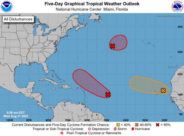
1. Shower and thunderstorm activity associated with an area of low pressure located several hundred miles east of the Lesser Antilles has changed little this morning. Although environmental conditions are only marginally conducive, additional gradual development of this system is expected and a tropical depression is likely to form within the next couple of days. The disturbance is forecast to move slowly toward the west-northwest, toward the adjacent waters of the northern Leeward Islands. Formation chance through 5 days…high…80 percent.
2. Showers and thunderstorms associated with a broad area of low pressure located between the west coast of Africa and the Cabo Verde Islands have become slightly better organized. Some gradual development is possible, and the system could become a short-lived tropical depression over the far eastern Atlantic during the next couple of days. By late this week, environmental conditions are forecast to become increasingly unfavorable for further development. Regardless, the system could bring locally heavy rainfall to portions of the Cabo Verde Islands through Thursday. Formation chance through 5 days…medium…50 percent.
3. An area of low pressure has formed along a decaying frontal zone over the central subtropical Atlantic about 850 miles west-southwest of the westernmost Azores. Environmental conditions are expected to be conducive for development, and a tropical or subtropical depression is likely to form during the next few days while the system drifts generally eastward. Formation chance through 5 days…high…70 percent.
BEACH FORECAST CENTER: Get the latest weather and rip current forecasts for the beaches from Fort Morgan to Panama City on our Beach Forecast Center page. There, you can select the forecast of the region that you are interested in visiting.
WORLD TEMPERATURE EXTREMES: Over the last 24 hours, the highest observation outside the U.S. was 118.4F at Khanaqin, Iraq. The lowest observation was -99.2F at Dome C, Antarctica.
CONTIGUOUS TEMPERATURE EXTREMES: Over the last 24 hours, the highest observation was 121F at Death Valley, CA. The lowest observation was 26F at Peter Sinks, UT.
Category: Alabama's Weather, ALL POSTS
About the Author (Author Profile)
Macon, Georgia Television Chief Meteorologist, Birmingham native, and long time Contributor on AlabamaWX. Stormchaser. I did not choose Weather, it chose Me. College Football Fanatic. @Ryan_StinnetSubscribe
If you enjoyed this article, subscribe to receive more just like it.


