

Midday Nowcast: Sunny and Hot; Newly Named Tropical Storm Danielle
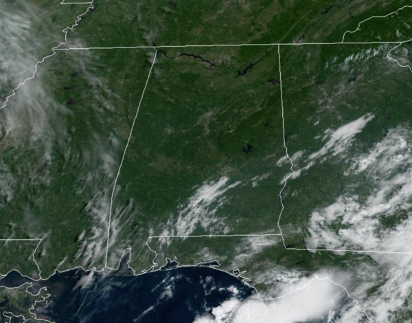
Another hot and mainly dry day with abundant sunshine for most of Alabama as temperatures climb into the low 90s. Rain chances are not zero, but are very low, and in fact the better rain chances today are across the Wiregrass Section of the state.
FRIDAY THROUGH MONDAY: Moisture levels begin to increase tomorrow and we will bring back the chance of showers and storms during the afternoon and evening hours. The forecast for the weekend, will feature partly sunny days, fair nights, with scattered to numerous showers and storms storms each day on occasion. No weekend washout, and no way of knowing in advance exactly when and where they form in advance, you just have to watch radar trends. Definitely have some indoor plans at times as you are likely to be dodging rain at some point. The chance of any one spot getting wet daily is 50-70%, and most of the showers and storms will come in the noon to midnight window. Afternoon highs Saturday through Monday will be in the low to mid 80s. Rain amounts of 1-2 inches are likely over the the holiday weekend for most places across Alabama.
FOOTBALL FORECAST: UAB kicks off their season tonight, hosting Alabama A&M at Protective Stadium in downtown Birmingham (7p CT kickoff). The sky will be clear with temperatures falling from near 83 at kickoff, into the 70s by the second half.
Auburn begins their season Saturday evening; they host Mercer at Jordan-Hare Stadium (6:00p CT kickoff). A shower or storm is very possible during the game; the sky will be mostly cloudy. About 81 at kickoff, upper 70s for most of the game.
Alabama also plays Saturday evening; they will host Utah State at Bryant Denny Stadium (6:30p CT kickoff)… pretty much the same situation as Auburn. A passing shower or storm is a distinct possibility, otherwise it will be a warm, humid night with temperatures falling from the low 80s at kickoff into the 70s for most of the game.
For all the other games in the state Saturday; scattered to numerous showers and storms will be around, but the day won’t be a washout. Take the rain gear.
NEXT WEEK: We will keep a persistence forecast going for the rest of the week with partly sunny days and scattered, mostly afternoon and evening showers and thunderstorms Tuesday through Friday. Highs will remain mostly in the mid to upper 80s.
IN THE TROPICS: Newly formed Tropical Depression Five quickly become Tropical Storm Danielle this morning, but is not a threat to the U.S. At 300 PM GMT, the center of Tropical Storm Danielle was located near latitude 38.1 North, longitude 44.7 West. Danielle is moving toward the east near 2 mph. The tropical storm is expected to meander during the next few days.
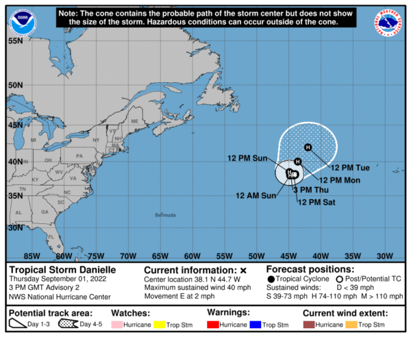
Maximum sustained winds have increased to near 40 mph with higher gusts. Strengthening is forecast during the next few days, and Danielle is expected to become a hurricane in two days or so. Tropical-storm-force winds extend outward up to 35 miles from the center. The estimated minimum central pressure is 1012 mb (29.89 inches).
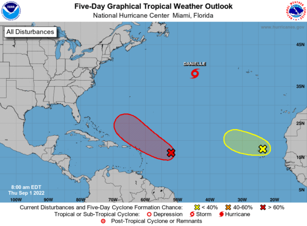
Elsewhere in the tropics, showers and thunderstorms associated with a broad area of low pressure located several hundred miles east of the Leeward Islands have changed little this morning. Although environmental conditions remain only marginally conducive, any additional development of the system over the next few days would lead to the formation of a tropical depression. The disturbance is forecast to move slowly west-northwestward, toward the adjacent waters of the northern Leeward Islands. Formation chance through 5 days…high…80 percent.
Also, satellite imagery and surface observations show that a broad area of low pressure is located over and to the northwest of the Cabo Verde Islands. While surface observations indicate pressures are low in this area, the associated shower activity is currently poorly organized. There is still some chance for the system to become a short-lived tropical depression within the next day or so before environmental conditions become unfavorable for further development. Regardless, the system could bring locally heavy rainfall to portions of the Cabo Verde Islands today and tonight. Formation chance through 5 days…low…30 percent.
BEACH FORECAST CENTER: Get the latest weather and rip current forecasts for the beaches from Fort Morgan to Panama City on our Beach Forecast Center page. There, you can select the forecast of the region that you are interested in visiting.
WORLD TEMPERATURE EXTREMES: Over the last 24 hours, the highest observation outside the U.S. was 114.4F at Adrar, Algeria. The lowest observation was -107.9F at Vostok, Antarctica.
CONTIGUOUS TEMPERATURE EXTREMES: Over the last 24 hours, the highest observation was 123F at Death Valley, CA. The lowest observation was 29F at Hamilton, MT.
Category: Alabama's Weather, ALL POSTS, Tropical
About the Author (Author Profile)
Macon, Georgia Television Chief Meteorologist, Birmingham native, and long time Contributor on AlabamaWX. Stormchaser. I did not choose Weather, it chose Me. College Football Fanatic. @Ryan_StinnetSubscribe
If you enjoyed this article, subscribe to receive more just like it.


