

Rain Likely Tomorrow; Occasional Showers Over The Weekend
RADAR CHECK: Most of Alabama is enjoying a mostly sunny day, but isolated showers have formed over the eastern counties, and we are seeing a few heavy storms over the southeast corner of the state. Temperatures are in the 80s, and clouds will increase tonight as moist air surges northward. Showers could form after midnight as a broad surface low forms over Louisiana.
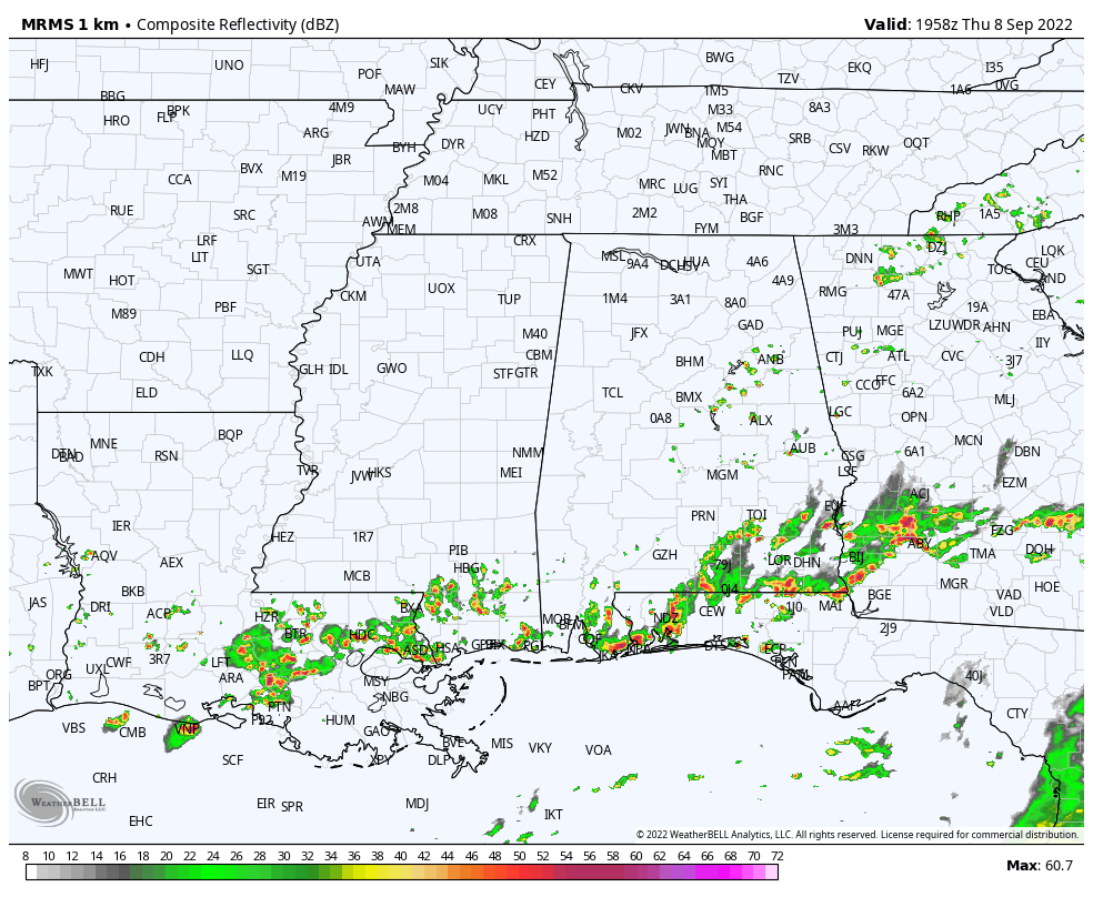
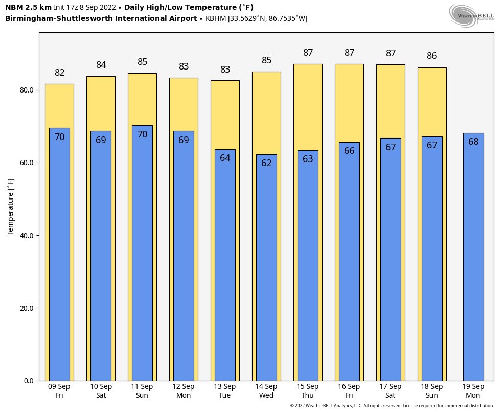
TOMORROW AND THE WEEKEND: Wet weather is the story tomorrow thanks to deep moisture in place and the broad surface low over Southeast Louisiana. Expect period of rain and a few thunderstorms… not an “all day/all night” rain, but when the rain does come it could be heavy in spots. Temperatures hold in the 70s all day due to clouds and showers.
The weather stays a bit unsettled over the weekend… we are forecasting scattered to numerous showers and thunderstorms Saturday and Sunday with only a limited amount of sun both days. Highs will be in the 80-84 degree range. Rain amounts between tomorrow and Sunday will be average around one inch, but some spots could see more.
NEXT WEEK: A dry, continental airmass begins to move into the state Monday, with showers mainly over East and South Alabama. Then, we will be rain-free for the rest of the week with sunny days, cooler nights, and lower humidity values. Highs will be in the 80s, lows mostly in the 60s… but many spots over North Alabama will be in the refreshing 50s early Tuesday and Wednesday morning. The dry weather will likely persist into the following weekend (September 17-18)… See the daily Weather Briefing video for maps, graphics, and more details.
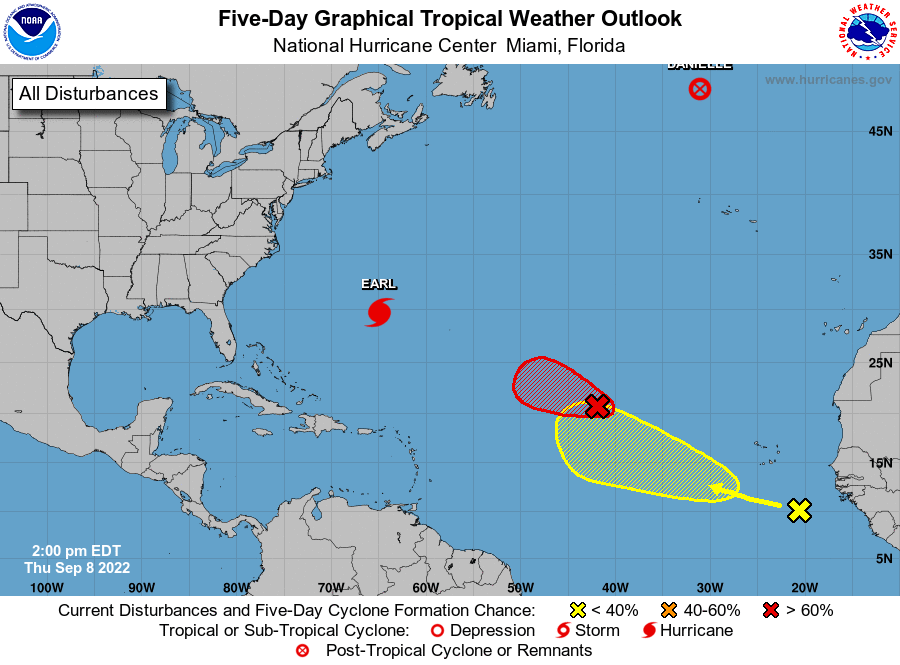
TROPICS: Earl is a category two hurricane in the Atlantic with winds of 105 mph; will pass east of Bermuda over the next 12 hours. Then Earl will move into the North Atlantic, becoming post-tropical this weekend.
Danielle has become post-tropical in the North Atlantic over cooler water. And, NHC is monitoring two tropical waves in the central and eastern Atlantic, but if those develop they will turn north and then northeast. Still no sign of any tropical systems threatening the U.S. Gulf Coast or Atlantic coast for the next 7-10 days.
FOOTBALL WEATHER: For the high school games across Alabama tomorrow night, periods of rain are likely with temperatures in the 70s.
Saturday, Alabama will take on Texas in Austin (11a CT kickoff)… the sky will be sunny with temperatures rising from near 90 at kickoff, into the mid 90s during the second half.
Auburn will host San Jose State Saturday evening at Jordan-Hare Stadium (6:30p CT kickoff)… the sky will be mostly cloudy with showers possible during the game. Temperatures will hover in the mid to upper 70s.
UAB plays at Liberty Saturday in Lynchburg, VA (5p CT kickoff)… the sky will be mostly clear with temperatures falling from 80 at kickoff, to near 70 by the final whistle.
ON THIS DATE IN 1900: A Category 4 storm made landfall in Galveston, Texas. This hurricane killed between 6,000 and 12,000 individuals, making it the deadliest US Atlantic hurricane on record. The number most cited in official reports is 8,000. Most of these deaths occurred in and near Galveston after the storm surge inundated the coastline with 10 to 15 ft of water. In addition to the number killed, the storm destroyed about 7,000 buildings of all uses in Galveston, which included 3,636 demolished homes; every dwelling in the city suffered some degree of damage. The hurricane left approximately 10,000 people in the city homeless, out of a total population of fewer than 38,000.
ON THIS DATE IN 1925: In September 1925, South Carolina was in the middle of one of the most widespread and disastrous droughts in the state’s history. The NWS Co-op station in Calhoun Falls reported 11 days above 100°F with a maximum temperature of 111°F on this day.
BEACH FORECAST: Click here to see the AlabamaWx Beach Forecast Center page.
Look for the next Weather Briefing video here by 6:00 a.m. tomorrow…
Category: Alabama's Weather, ALL POSTS, Weather Xtreme Videos
About the Author (Author Profile)
James Spann is one of the most recognized and trusted television meteorologists in the industry. He holds the AMS CCM designation and television seals from the AMS and NWA. He is a past winner of the Broadcast Meteorologist of the Year from both professional organizations.Subscribe
If you enjoyed this article, subscribe to receive more just like it.


