

Midday Nowcast: Clearing Sky with a Hint of Fall Ahead
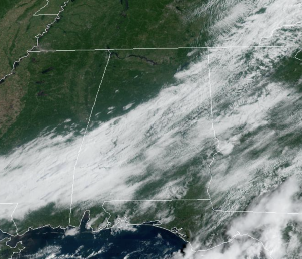
The front continues to move through Southeast Alabama, and this is where any lingering showers activity will be the afternoon. For the rest of the state, we are are seeing a clearing sky and through the afternoon we should all be sunny. We have north breeze as well, which is bringing in the lower humidity values. Highs this afternoon will be on either side of 80°.
LONG, DRY SPELL AHEAD: Look for sunny, warm days, and clear pleasant, nights tomorrow through Friday. The next several mornings will features morning lows well down in the 50s across much of Alabama. Highs will be in the 80s, but with lower humidity levels, it will be noticeably more comfortable for us.
THE ALABAMA WEEKEND: Dry weather continues with a good supply of sunshine Saturday and Sunday with highs in the mid to upper 80s and lows in the 60s. No rain worries for college games across the state Saturday.
NEXT WEEK: More of the same as the quiet weather pattern continues. Humidity levels will creep up with highs in the mid to upper 80s; a few isolated showers could show up over the latter half of the week, but we see no sign of any major rain event during the week.
IN THE TROPICS: No active storms in the Atlantic currently, but 50% of hurricane season is left. The NHC is monitoring two tropical waves for potential slow development.
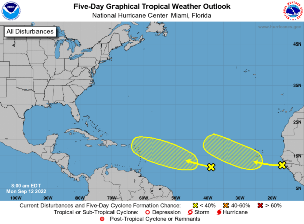
A tropical wave located just off the west coast of Africa is producing an area of disorganized showers and thunderstorms. Environmental conditions appear only marginally favorable, and any development of this wave should be slow to occur while it moves westward or west-northwestward across the eastern tropical Atlantic through the end of the week. Formation chance through 5 days…low…20 percent.
A tropical wave located midway between the west coast of Africa and the Windward Islands is producing a large area of disorganized showers and thunderstorms. Some slow development of this system is possible over the next several days while it moves generally westward to west-northwestward over the central tropical Atlantic and approaches the Windward Islands by the end of the week. Formation chance through 5 days…low…20 percent.
BEACH FORECAST CENTER: Get the latest weather and rip current forecasts for the beaches from Fort Morgan to Panama City on our Beach Forecast Center page. There, you can select the forecast of the region that you are interested in visiting.
WORLD TEMPERATURE EXTREMES: Over the last 24 hours, the highest observation outside the U.S. was 117.5F at Abdaly, Kuwait. The lowest observation was -92.6F at Dome A, Antarctica.
CONTIGUOUS TEMPERATURE EXTREMES: Over the last 24 hours, the highest observation was 106F at Death Valley, CA. The lowest observation was 12F at Peter Sinks, UT.
Category: Alabama's Weather, ALL POSTS
About the Author (Author Profile)
Macon, Georgia Television Chief Meteorologist, Birmingham native, and long time Contributor on AlabamaWX. Stormchaser. I did not choose Weather, it chose Me. College Football Fanatic. @Ryan_StinnetSubscribe
If you enjoyed this article, subscribe to receive more just like it.


