

A Fall Feel To The Air Tonight As Dry Air Arrives
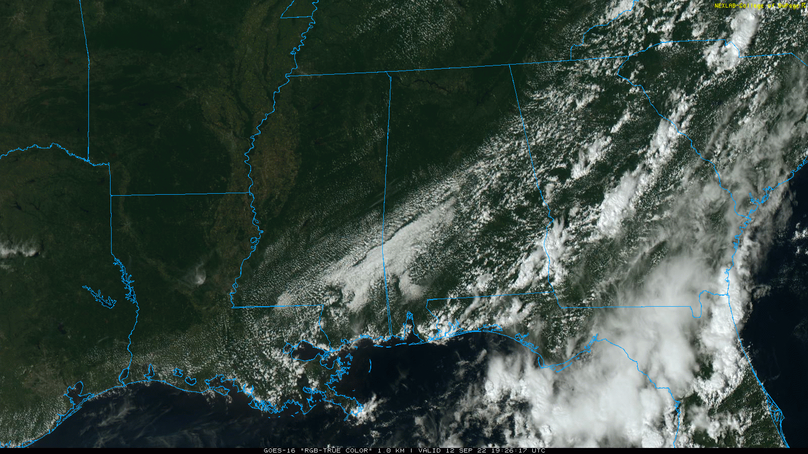
RADAR CHECK: Showers and storms are confined to far South and Southeast Alabama this afternoon ahead of a cold front that will push into the northern Gulf of Mexico tonight. North/Central Alabama is a much drier airmass, with lower humidity, and that dry air will reach the coast tonight. With a clear sky, temperatures will drop into the cool 50s over the northern half of the state late tonight and early tomorrow for a nice touch of fall.
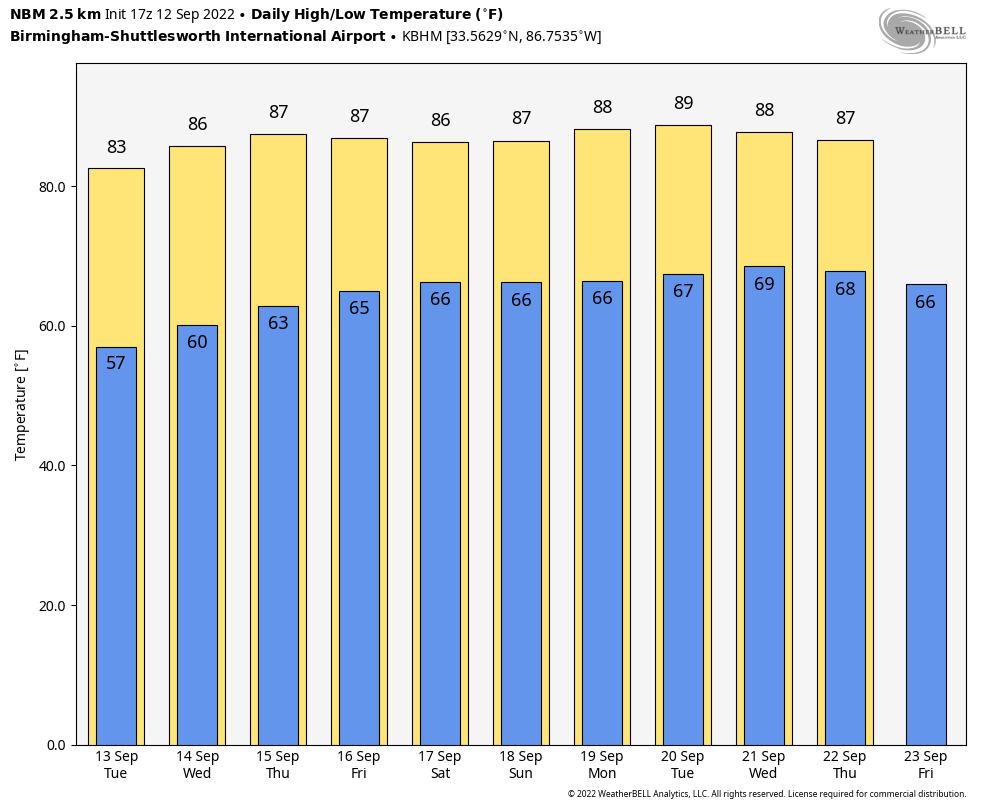
Look for sunny warm days and clear pleasant nights tomorrow through Friday with highs in the 80s. We will be in the 50s again early Wednesday… followed by lows in the 60s Thursday and Friday.
THE ALABAMA WEEKEND: No change. Most of the state will enjoy sunny days and fair nights with highs in the 80s. A couple of isolated showers can’t be ruled out over the far southern part of the state, but the chance of any one spot seeing rain there is only 10-20 percent both days.
NEXT WEEK: The dry pattern continues… for now most of the week looks rain free with highs holding in the 80s. Long range guidance for now really doesn’t show any high impact or heavy rain event for the state for the next 10-15 days. See the daily Weather Briefing video for maps, graphics, and more details.
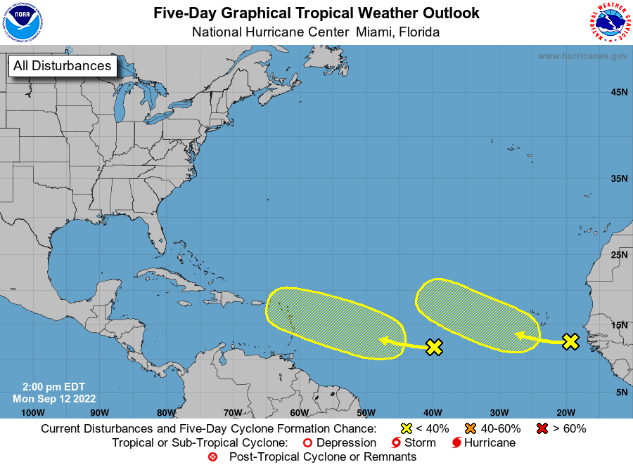
TROPICS: NHC is monitoring two tropical waves in the eastern Atlantic; those have only a 20 percent chance of development over the next five days. The rest of the Atlantic basin remains very quiet, and no tropical systems will threaten the U.S. at least for the next 7-10 days.
ON THIS DATE IN 1979: Hurricane Frederic crossed over the western end of Dauphin Island around 10p CT. An automated wind gust recorder at the top of the Dauphin Island Bridge recorded a peak wind gust of 145 mph around 9:40p. At landfall, Frederic was a Category 4 on the Saffir-Simpson Hurricane intensity scale, raking the Mobile Bay area with winds gusting from 100-145 mph for several hours on the evening of September 12 through the early morning of September 13. Hurricane wind gusts were experienced as far inland as Choctaw County during the early morning hours of September 13.
Near-total property damage occurred along the Alabama coastline between Fort Morgan and Gulf Shores, the latter seeing 80% of its buildings completely destroyed. The causeway linking Dauphin Island to the mainland was swept away in many areas. Mobile suffered extensive damage as well. Structural failure was widespread in the immediate landfall area with industrial, residential and governmental buildings as well as hospitals suffering heavy damage. Nearly 90% of the Mobile area lost electricity, and the historic City Hall experienced heavy roof damage. Many small beach houses were completely destroyed by high winds before the storm surge could add any effects.
The rebuilding process after Frederic was responsible for the transformation of Gulf Shores and Orange Beach… from small coastal villages to the booming tourist destination they are now.
ON THIS DATE IN 1999: Hurricane Floyd, a Category 4 storm with top winds of 145 mph, was making residents along the U.S. East Coast very nervous as it steamed steadily westward. Floyd was once forecast to strike Florida but turned away. Instead, Floyd hit the Bahamas at peak strength, causing substantial damage. It then paralleled the East Coast of the United States, causing massive evacuations and costly preparations from Florida through the Mid-Atlantic States.
BEACH FORECAST: Click here to see the AlabamaWx Beach Forecast Center page.
Look for the next Weather Briefing video here by 6:00 a.m. tomorrow…
Category: Alabama's Weather, ALL POSTS, Weather Xtreme Videos
About the Author (Author Profile)
James Spann is one of the most recognized and trusted television meteorologists in the industry. He holds the AMS CCM designation and television seals from the AMS and NWA. He is a past winner of the Broadcast Meteorologist of the Year from both professional organizations.Subscribe
If you enjoyed this article, subscribe to receive more just like it.


