


Another great start to the day, but sunshine is warming us up due to the dry air in place, temperatures this afternoon are in the mid 80s for most locations. Tomorrow and Friday, expect more of the same with sunny, warm days with highs mid and upper 80s. Again, humidity levels are very low, making it feel comfortable, even during the afternoon hours. With no moisture to work with, there is no threat for rain in the forecast.
WEEKEND & NEXT WEEK: Dry weather continues with a good supply of sunshine Saturday and Sunday with highs in the mid to upper 80s and lows in the 60s. No rain worries for college games across the state Saturday. For next week, more of the same as the quiet weather pattern continues. Highs in the mid to upper 80s will be common and we may have to mention the chance for a few isolated showers late in the week, but no signs of any major rain event the next ten days or so…it certainly is a long dry spell.
FOOTBALL WEATHER: Clear weather is the story for the high school football games across Alabama Friday night with temperatures falling into the 70s during the games.
Saturday, Auburn hosts Penn State (2:30p CT kickoff) at Jordan-Hare Stadium… the sky will be sunny; about 87 degrees at kickoff.
Alabama will host LA-Monroe Saturday (3:00p CT kickoff) at Bryant-Denny Stadium. It will be sunny and very warm with temperatures falling from near 88 degrees at kickoff into the low 80s by the final whistle.
UAB is also at home; they host Georgia Southern at Protective Stadium in downtown Birmingham Saturday (2:30p CT kickoff). Expect a sunny sky with a kickoff temperature around 87 degrees… lows 80s by the end of the game.
FUTURE FIONA?: One of the tropical waves we have been watching is now Tropical Depression Seven, and should become Fiona. The center of Tropical Depression Seven was located near latitude 16.6 North, longitude 49.6 West. The depression is moving toward the west near 14 mph, and this general motion is expected to continue during the next few days. On the forecast track, the center of the system is forecast to move through the Leeward Islands on Friday or Friday night, and be near the Virgin Islands and Puerto Rico this weekend.
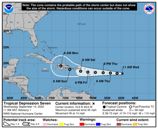
Maximum sustained winds are near 35 mph with higher gusts. Some gradual strengthening is forecast during the next day or so, and the depression is forecast to become a tropical storm tonight or Thursday. The estimated minimum central pressure is 1009 mb (29.80 inches).
The rest of the Atlantic is quiet for now.
BEACH FORECAST CENTER: Get the latest weather and rip current forecasts for the beaches from Fort Morgan to Panama City on our Beach Forecast Center page. There, you can select the forecast of the region that you are interested in visiting.
WORLD TEMPERATURE EXTREMES: Over the last 24 hours, the highest observation outside the U.S. was 120.0F at Jahra, Kuwait. The lowest observation was -94.9F at Dome A, Antarctica.
CONTIGUOUS TEMPERATURE EXTREMES: Over the last 24 hours, the highest observation was 101F at Rio Grande Village, TX. The lowest observation was 27F at Old Station, CA.


