

Midday Nowcast: Another Sun-Filled Day of Weather
Tons of sunshine again today with temperatures this afternoon in the mid to upper 80s across Alabama. Humidity levels remain very tolerable, so though it is very warm, it is not oppressive outside. With little to no moisture to work with, there is no threat for rain today or tomorrow. Our Friday will be another sun-filled day with highs in the upper 80s for most locations across North/Central Alabama.
FRIDAY NIGHT LIGHTS: Clear weather is the story for the high school football games across Alabama tomorrow night with temperatures falling into the 70s during the games.
DRY PATTERN PERSIST: As we roll into the weekend, the dry weather continues with a good supply of sunshine Saturday and Sunday with highs in the mid to upper 80s and lows in the 60s. No rain worries for college games across the state Saturday. For next week, more of the same as the quiet weather pattern continues. Highs in the upper 80s and low 90s will be common each day. No signs of any major rain event the next ten days or so as the long dry spell will persist.
FOOTBALL WEATHER: Saturday, Auburn hosts Penn State (2:30p CT kickoff) at Jordan-Hare Stadium… the sky will be sunny; about 87 degrees at kickoff. Alabama will host LA-Monroe Saturday (3:00p CT kickoff) at Bryant-Denny Stadium. It will be sunny and very warm with temperatures falling from near 88 degrees at kickoff into the low 80s by the final whistle.
UAB is also at home; they host Georgia Southern at Protective Stadium in downtown Birmingham Saturday (2:30p CT kickoff). Expect a sunny sky with a kickoff temperature around 87 degrees… lows 80s by the end of the game.
TROPICAL STORM FIONA: At 1100 AM AST, the center of Tropical Storm Fiona was located near latitude 16.6 North, longitude 54.3 West. Fiona is moving toward the west near 14 mph. A westward motion with some decrease in forward speed is expected to continue through late Saturday, with a turn toward the west-northwest possible on Sunday. On the forecast track, the center of Fiona is expected to move across the Leeward Islands Friday night and early Saturday, and move near the Virgin Islands and Puerto Rico late Saturday into Sunday.
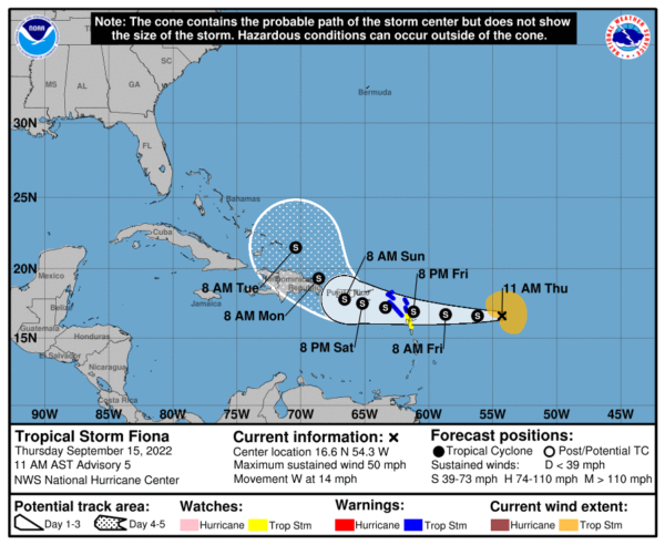
Maximum sustained winds are near 50 mph with higher gusts. Some slow strengthening is possible during the next few days. Tropical-storm-force winds extend outward up to 140 miles mainly to the north of the center. The estimated minimum central pressure is 1002 mb (29.59 inches).
The rest of the Atlantic is quiet for now.
BEACH FORECAST CENTER: Get the latest weather and rip current forecasts for the beaches from Fort Morgan to Panama City on our Beach Forecast Center page. There, you can select the forecast of the region that you are interested in visiting.
WORLD TEMPERATURE EXTREMES: Over the last 24 hours, the highest observation outside the U.S. was 120.4F at Sulaibiya, Kuwait. The lowest observation was -94.7F at Dome A, Antarctica.
CONTIGUOUS TEMPERATURE EXTREMES: Over the last 24 hours, the highest observation was 104F at Death Valley, CA. The lowest observation was 26F at Adin, CA.
Category: Alabama's Weather, ALL POSTS
About the Author (Author Profile)
Macon, Georgia Television Chief Meteorologist, Birmingham native, and long time Contributor on AlabamaWX. Stormchaser. I did not choose Weather, it chose Me. College Football Fanatic. @Ryan_StinnetSubscribe
If you enjoyed this article, subscribe to receive more just like it.


