

Midday Nowcast: Sun, Haze, and Tropical Storm Fiona
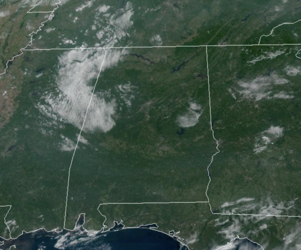
Our Friday is another sun-filled day of weather with highs in the upper 80s for most locations across North/Central Alabama. We do note, there is some haze in the sky over Alabama, and this is smoke from wildfires across the Western United States. It remains dry, and for those high school football games tonight, clear weather is the story with temperatures falling into the 70s during the games.
STAYING DRY, ALMOST HOT: For our weekend, the dry weather continues with a good supply of sunshine tomorrow and Sunday with highs in the mid to upper 80s, and lows in the 60s. For next week, more of the same as the quiet weather pattern continues. Highs in the upper 80s and low 90s will be common each day. No signs of any major rain event the next ten days or so as the long dry spell will persist.
FOOTBALL WEATHER: Tomorrow, Auburn hosts Penn State (2:30p CT kickoff) at Jordan-Hare Stadium… the sky will be sunny; about 87 degrees at kickoff.
Alabama will host LA-Monroe tomorrow (3:00p CT kickoff) at Bryant-Denny Stadium. It will be sunny and very warm with temperatures falling from near 88 degrees at kickoff into the low 80s by the final whistle.
UAB is also at home; they host Georgia Southern at Protective Stadium in downtown Birmingham tomorrow (2:30p CT kickoff). Expect a sunny sky with a kickoff temperature around 87 degrees… lows 80s by the end of the game.
TROPICAL STORM FIONA: At 1100 AM AST, the center of Tropical Storm Fiona was located near latitude 16.0 North, longitude 59.4 West. Fiona is moving toward the west near 14 mph. A westward motion with a decrease in forward speed is expected through early Sunday, followed by a turn toward the west-northwest and northwest Sunday and Sunday night. On the forecast track, the center of Fiona is expected to move across the Leeward Islands tonight, near or just south of the Virgin Islands and Puerto Rico Saturday into Sunday, and approach the southern coast of the Dominican Republic Sunday night and early Monday. These islands will have impacts on the system as they are very mountainous, we will have to see how it survives the island hoping through the weekend. If it does, some of the model do take then system up to hurricane intensity by the middle of next week over the Turks and Caicos.
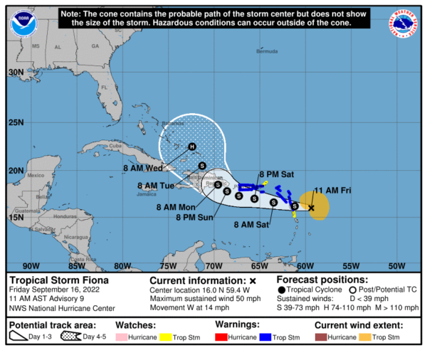
Data from Air Force Reserve and NOAA Hurricane Hunter aircraft indicate that maximum sustained winds are near 50 mph with higher gusts. Gradual strengthening is forecast during the next few days. Tropical-storm-force winds extend outward up to 140 miles from the center. The estimated minimum central pressure is 1005 mb (29.68 inches).
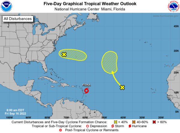
Also, a frontal low over the western Atlantic Ocean a few hundred miles west-northwest of Bermuda is producing disorganized showers and thunderstorms. This low is expected to move eastward to east-southeastward at 10 to 15 mph, and development into a tropical cyclone is not anticipated due to strong upper-level winds. Formation chance through 5 days…low…10 percent.
Plus, disorganized showers and thunderstorms over the central tropical Atlantic Ocean are associated with the northern end of a tropical wave. Some slow development of this system is possible early next week while it moves northwestward to northward over the central subtropical Atlantic. Formation chance through 5 days…low…20 percent.
BEACH FORECAST CENTER: Get the latest weather and rip current forecasts for the beaches from Fort Morgan to Panama City on our Beach Forecast Center page. There, you can select the forecast of the region that you are interested in visiting.
WORLD TEMPERATURE EXTREMES: Over the last 24 hours, the highest observation outside the U.S. was 122.4F at Kroonstad, South Africa. The lowest observation was -94.0F at Amundsen-Scott South Pole Station, Antarctica.
CONTIGUOUS TEMPERATURE EXTREMES: Over the last 24 hours, the highest observation was 101F at Death Valley, CA and Rio Grande Village, TX. The lowest observation was 27F at Mount Washington, NH.
Category: Alabama's Weather, ALL POSTS
About the Author (Author Profile)
Macon, Georgia Television Chief Meteorologist, Birmingham native, and long time Contributor on AlabamaWX. Stormchaser. I did not choose Weather, it chose Me. College Football Fanatic. @Ryan_StinnetSubscribe
If you enjoyed this article, subscribe to receive more just like it.


