

Midday Nowcast: Fine Fall Friday; Watching the Tropics
Beautiful weather across Alabama today as the cooler, drier air mass settles into the state. We are seeing sunshine in full supply with temperatures in the low 80s, which are 10-15 degrees cooler than yesterday. Humidity is much lower today as well, and overall a great full first day of fall.
FRIDAY NIGHT LIGHTS: Delightful weather for high school games tonight across Alabama; the sky will be clear with temperatures falling into the 60s.
WONDERFUL WEEKEND WEATHER: Tomorrow morning will be refreshing with 50s, the high tomorrow will be in the mid 80s with a sunny sky. Then, for Sunday, we expect a mix of sun and clouds, and we will mention the chance of a few showers Sunday afternoon and evening as another cold front moves through the state. Moisture will be very limited, and rain amounts will be light and spotty. The high Sunday will be in the upper 80s.
FOOTBALL WEATHER: Tomorrow, Auburn hosts Missouri at Jordan-Hare Stadium (11a CT kickoff)… the sky will be sunny with temperatures rising from near 77 and kickoff, into the low 80s by the second half.
Alabama will host Vanderbilt at Bryant Denny Stadium tomorrow evening (6:30p CT kickoff)… the sky will be clear with temperatures falling from 81 degrees at kickoff, into the low 70s by the final whistle.
HURRICANE FIONA: At 1100 AM AST, the eye of Hurricane Fiona was located near latitude 35.9 North, longitude 64.2 West. Fiona is moving toward the northeast near 35 mph. A slower north-northeast or north motion is expected later today through Sunday. On the forecast track, the center of Fiona will approach Nova Scotia later today, move across Nova Scotia and into the Gulf of St. Lawrence on Saturday, and then across Labrador and over the Labrador Sea on Sunday.
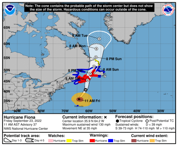
Maximum sustained winds are near 130 mph with higher gusts. Fiona is a category 4 hurricane on the Saffir-Simpson Hurricane Wind Scale. Although gradual weakening is forecast, Fiona is expected to be a powerful hurricane-force cyclone when it moves across Atlantic Canada. Hurricane-force winds extend outward up to 115 miles from the center and tropical-storm-force winds extend outward up to 345 miles. The minimum central pressure based on data from an Air Force Hurricane Hunter aircraft is 936 mb (27.64 inches).
TROPICAL DEPRESSION NINE: At 1100 AM EDT, the center of Tropical Depression Nine was located near latitude 14.2 North, longitude 70.1 West. The depression is moving toward the west-northwest near 14 mph. A westward motion is expected to begin later today and continue through Saturday, followed by a turn toward the west-northwest and northwest on Sunday and Monday. On the forecast track, the center of the cyclone is forecast to move across the central Caribbean Sea through Saturday, pass south of Jamaica on Saturday night and Sunday, and approach the Cayman Islands on Sunday night and early Monday.
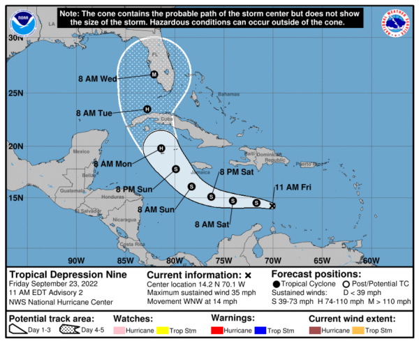
Maximum sustained winds are near 35 mph with higher gusts. Some slow strengthening is forecast during the next day or so, and the depression is expected to become a tropical storm by tonight. More significant intensification is forecast on Sunday and Monday. The estimated minimum central pressure is 1006 mb (29.71 inches).
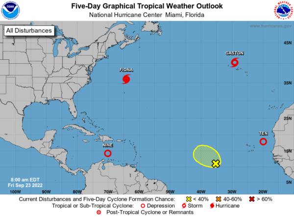
This should become Hermine, but we have a new Tropical Depression Ten in the eastern Atlantic which could get the name first, then it would be Ian.
NEXT WEEK: Most of the week looks dry at this point with very pleasant temperatures; highs around 80, with lows in the 50s and 60s.
BEACH FORECAST CENTER: Get the latest weather and rip current forecasts for the beaches from Fort Morgan to Panama City on our Beach Forecast Center page. There, you can select the forecast of the region that you are interested in visiting.
WORLD TEMPERATURE EXTREMES: Over the last 24 hours, the highest observation outside the U.S. was 110.8F at Omidieh, Iran. The lowest observation was -94.2F at Vostok, Antarctica.
CONTIGUOUS TEMPERATURE EXTREMES: Over the last 24 hours, the highest observation was 103F at Mecca, CA. The lowest observation was 16F at Bodie, CA.
Category: Alabama's Weather, ALL POSTS
About the Author (Author Profile)
Macon, Georgia Television Chief Meteorologist, Birmingham native, and long time Contributor on AlabamaWX. Stormchaser. I did not choose Weather, it chose Me. College Football Fanatic. @Ryan_StinnetSubscribe
If you enjoyed this article, subscribe to receive more just like it.


