

Nice & Mild for Central Alabama, but the Tropics Are Stealing the Show at Midday

Tons of sunshine outdoors today, with nary a cloud in the sky across Central Alabama. It’s a mild one out there, with temperatures in the 70s for the most part as of the 11 am roundup. Troy is the only outlaw out of the 70s at 80º. The cool spot was Alexander City at 73º. Birmingham was sitting at 78º. We’ll keep those sunny skies and highs will eventually top out in the mid to upper 80s this afternoon.
We’ll start to see a change across the area later tonight as clouds will begin to move in from the west and northwest, with showers and thunderstorms becoming possible for the northwestern parts of Central Alabama right around midnight. Those shower and storm chances will continue to increase across the rest of the northern half of the area through the pre-dawn hours. Lows will be in the lower to mid 60s.
That rain will be associated with a cold front, and that front will move through the area during the latter part of your Sunday, which will make scattered showers and storms possible throughout the day. No severe weather is expected, but I wouldn’t count out a strong storm with gusty winds. Highs will be in the mid 80s to the lower 90s across the area from northwest to southeast.
LATEST ADVISORY ON TROPICAL STORM IAN
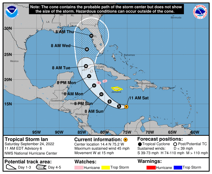
At 10 am, the center of Tropical Storm Ian was located around 270 southeast of Kingston, Jamaica. Ian is moving toward the west near 15 mph, and this general motion is expected to continue through tonight. A turn toward the northwest is forecast on Sunday, followed by a north-northwestward turn on Monday and a northward motion on Tuesday. On the forecast track, the center of Ian is forecast to move across the central Caribbean Sea today, pass southwest of Jamaica on Sunday, and pass near or over the Cayman Islands Sunday night and early Monday. Ian will then approach western Cuba late Monday and emerge over the southeastern Gulf of Mexico on Tuesday.
Maximum sustained winds remain near 45 mph, with higher gusts. Significant strengthening is forecast during the next few days. Ian is expected to become a hurricane late Sunday or Sunday night, and could be at or near major hurricane strength late Monday when it approaches western Cuba. Tropical-storm-force winds extend outward up to 60 miles from the center. The estimated minimum central pressure is 1003 mb (29.62 inches) based on NOAA Hurricane Hunter dropsonde data.
A Hurricane Watch is in effect for the Cayman Islands. A Tropical Storm Watch is in effect for Jamaica.
KEY MESSAGES
1. Ian is expected to produce heavy rainfall, flash flooding, and possible mudslides in areas of higher terrain, particularly over Jamaica and Cuba. Limited flash and urban flooding is possible with rainfall across the Florida Keys and Florida peninsula through mid next week.
2. Hurricane conditions are possible in the Cayman Islands by early Monday, with tropical storm conditions possible by late Sunday. Tropical storm conditions are possible in Jamaica on Sunday.
3. Ian is forecast to move near or over western Cuba and approach the west coast of the Florida peninsula at or near major hurricane strength early next week, where there is increasing confidence in multiple life-threatening hazards: storm surge, hurricane-force winds and rainfall flooding. While it is too soon to determine the exact magnitude and location of these hazards, residents in Cuba, the Florida Keys, and the Florida peninsula should ensure they have their hurricane plan in place, follow any advice given by local officials, and closely monitor updates to the forecast.
POTENTIAL ALABAMA GULF COAST IMPACTS FROM IAN
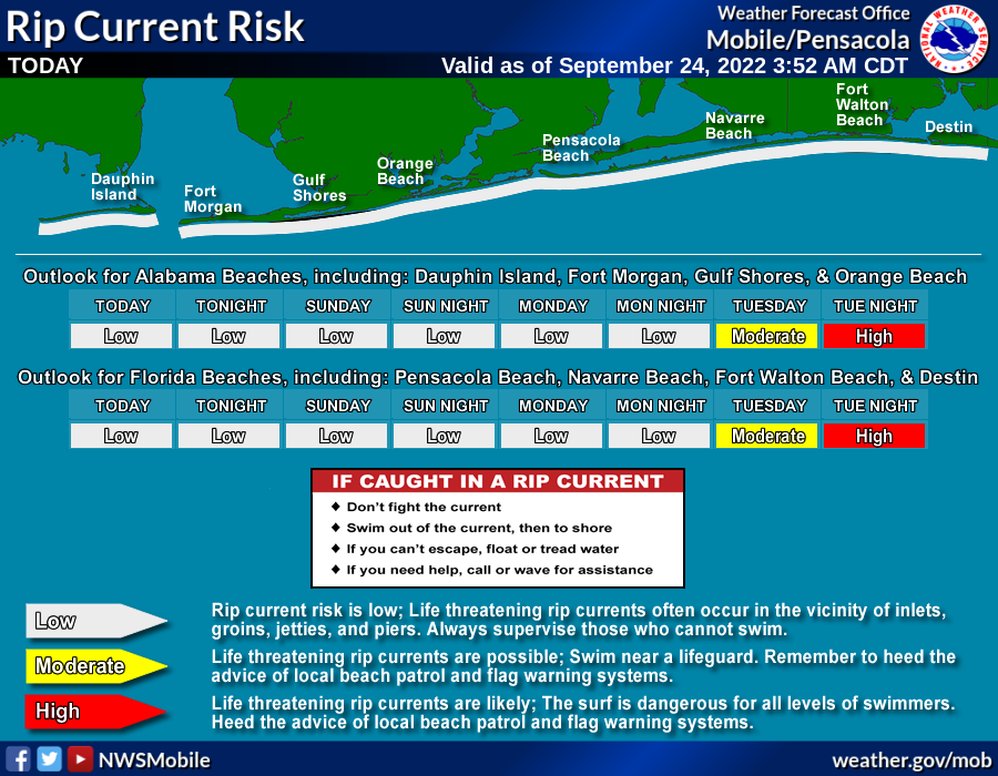
Swell associated with this system may lead to an elevated risk of rip currents, increased surf, and increased wave heights by the middle of next week. Outside those beach and marine hazards, it is too early to determine any other impacts to the area. However, it is too early to let your guard down.
THE REST OF THE TROPICS AS OF 10 AM
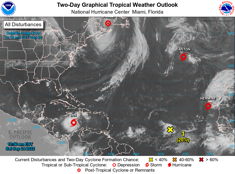
The center of Post-Tropical Cyclone Fiona was located around 100 miles west-northwest of Port Aux Basques, Newfoundland. The post-tropical cyclone is moving toward the north near 25 mph, and a slightly slower northward motion is expected during the next few days. On the forecast track, the center of Fiona will move across the Gulf of St. Lawrence today, and then move across Labrador and over the Labrador Sea on Sunday. Maximum sustained winds are near 80 mph, with higher gusts. Gradual weakening is expected during the next couple of days. Hurricane-force winds extend outward up to 115 miles from the center, and tropical-storm-force winds extend outward up to 405 miles. The estimated minimum central pressure based on surface observations is 945 mb (27.91 inches).
The center of Tropical Storm Gaston was located around 120 miles west-southwest of Faial Islands in the Central Azores. Gaston is moving toward the west-southwest near 9 mph. A turn toward the west is anticipated later today, followed by a turn to the southwest by late Sunday. Maximum sustained winds are near 45 mph, with higher gusts. Gradual weakening is forecast over the next few days, and Gaston is expected to become a post-tropical cyclone later today. Tropical-storm-force winds extend outward up to 160 miles from the center. The estimated minimum central pressure is 1001 mb (29.56 inches).
The center of Tropical Storm Hermine was located around 390 miles north-northeast of the Cabo Verde Islands. Hermine is moving toward the north near 8 mph, and this motion is expected to continue during the next day or two. After that time, a turn toward the northwest is expected. Maximum sustained winds remain near 40 mph, with higher gusts. Weakening is forecast, and Hermine is expected to become a remnant low in a day or two. Tropical-storm-force winds extend outward up to 45 miles from the center. The estimated minimum central pressure is 1002 mb (29.59 inches).
Showers and thunderstorms remain disorganized in association with a broad area of low pressure located several hundred miles west-southwest of the Cabo Verde Islands. Despite unfavorable upper-level winds, some slow development of this system is possible over the next several days while it drifts northwestward or northward over the central tropical Atlantic.
* Formation chance through 48 hours… low… 20 percent.
* Formation chance through 5 days… low… 30 percent.
Category: Alabama's Weather, ALL POSTS, Tropical
About the Author (Author Profile)
Scott Martin is an operational meteorologist, professional graphic artist, musician, husband, and father. Not only is Scott a member of the National Weather Association, but he is also the Central Alabama Chapter of the NWA president. Scott is also the co-founder of Racecast Weather, which provides forecasts for many racing series across the USA. He also supplies forecasts for the BassMaster Elite Series events including the BassMaster Classic.Subscribe
If you enjoyed this article, subscribe to receive more just like it.


