

Noon Update: Showers and Storms Pushing Southeast Ahead of Front; Ian Still Poised to be Major Hurricane in Gulf
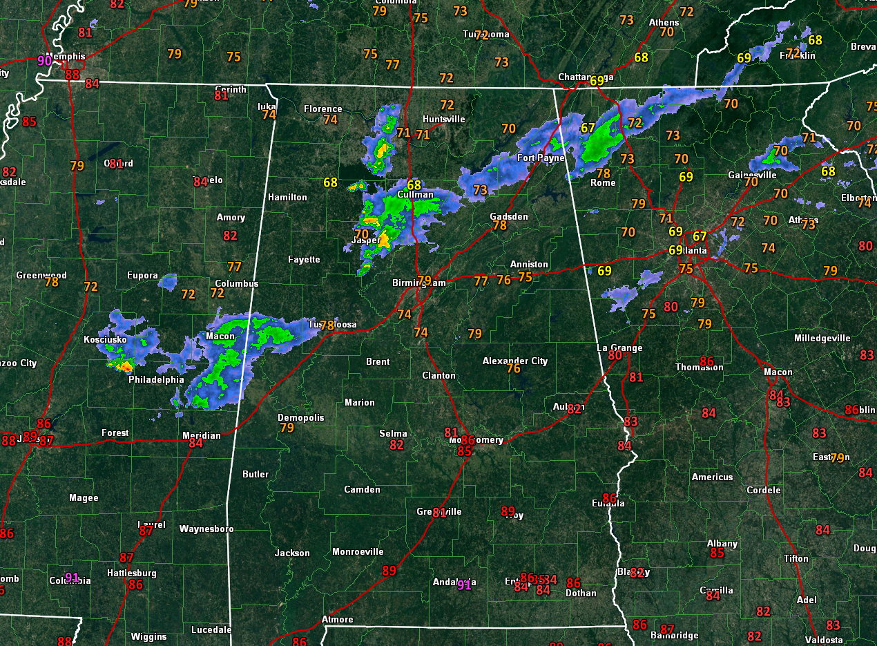
Showers and storms are spreading southeastward area spreading southeastward early this afternoon ahead of a cold front. A few lightning flashes have been showing up over Winston and Lawrence Counties with storms that extend from Double Springs down to the east of Jasper.
Finding the front is not hard to do at this hour. It is somewhere near I-40 in western Tennessee. Skies will clear pretty quickly behind the front.
Ahead of it, a few showers and storms are possible for the next few hours across North Central Alabama.
Dewpoints drop into the 50s a few hours behind the front, and that gift of drier and effectively cooler air will arrive in Northwest Alabama this evening, reaching Tuscaloosa, Birmingham, and Anniston around sunrise. Can’t rule out a stray shower or two with this secondary front. Skies will clear out again as soon as the showers pass.
Monday will be a beautiful day. You will notice a few little puffs of wind tomorrow, which will gust at times to around 15 mph or so. High temperatures will be in the 70s in the Tennessee Valley, and lower 80s across Central Alabama.
Tuesday and Wednesday look delightful for North and Central Alabama. Highs will be in the upper 70s Tuesday and middle 70s Wednesday. You will start to feel breezy conditions Tuesday, and especially Wednesday as the pressure gradient between high-pressure to the north and the deep low to the south that is Ian increases our winds. Skies will be 100% Tuesday and partly cloudy on Wednesday.
Of course, all eyes will be on Ian, which is still expected to begin strengthening soon over the northwestern Caribbean. That hasn’t happened yet, bu the NHC does note that the low-level circulation has improved markedly. The system just needs to become vertically stacked, which it is trying to do.
One of the most reliable intensity indicators shows that there is a 90 percent chance of rapid intensification over the next 2-3 days.
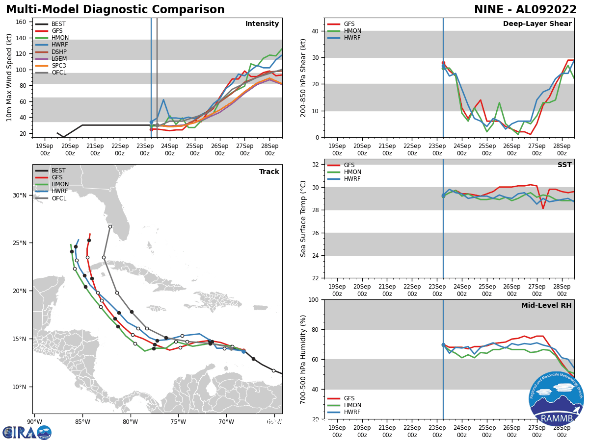
Still lots of uncertainty in the forecast given the amount of model spread we still have. The European takes a much weaker storm to Tampa, which seems unrealistic but is still possible. The operational GFS has shifted a little to the east with a landfall near Panama City. The HMON model is close to that, near Apalachicola. The HWRF is now the outlier to the west with a landfall near Destin.
The official track from the Hurricane Center calls for a landfall in the Florida Big Bend south of Tallahassee. The hurricane becomes very strong according to most of the guidance with most of the hurricane models taking it to Cat Four before weakening it as it encounters drier air and increasing wind shear over the northern Gulf of Mexico. At landfall, it appears that the storm will be a category one at landfall, with winds below 90 mph.
It will be an interesting five days, and a nerve-wracking one for Florida.
Category: Alabama's Weather, ALL POSTS, Tropical
About the Author (Author Profile)
Bill Murray is the President of The Weather Factory. He is the site's official weather historian and a weekend forecaster. He also anchors the site's severe weather coverage. Bill Murray is the proud holder of National Weather Association Digital Seal #0001 @wxhistorianSubscribe
If you enjoyed this article, subscribe to receive more just like it.


