

Ian Continues to Grow Stronger; Conditions to Deteriorate in Cuba This Evening
SUMMARY OF 1000 AM CDT…1500 UTC…INFORMATION
———————————————–
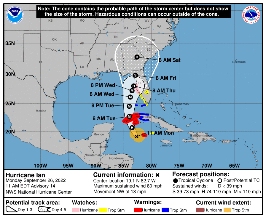
LOCATION…19.1 N, 82.7 W
ABOUT 100 MI…160 KM W OF GRAND CAYMAN
ABOUT 240 MI…385 KM SE OF THE WESTERN TIP OF CUBA
MAXIMUM SUSTAINED WINDS…80 MPH…130 KM/H
PRESENT MOVEMENT…NW OR 325 DEGREES AT 13 MPH…20 KM/H
MINIMUM CENTRAL PRESSURE…980 MB…28.94 INCHES
SUMMARY OF WATCHES AND WARNINGS IN EFFECT
———————————————–
A Hurricane Warning is in effect for…
* Grand Cayman
* Cuban provinces of Isla de Juventud, Pinar del Rio, and Artemisa
A Tropical Storm Warning is in effect for…
* Cuban provinces of La Habana, Mayabeque, and Matanzas
* Lower Florida Keys from Seven Mile Bridge westward to Key West
* Dry Tortugas
A Storm Surge Watch is in effect for…
* Florida Keys from the Card Sound Bridge westward to Key West
* Dry Tortugas
* Florida Bay
* Anclote River southward to the Card Sound Bridge
* Tampa Bay
A Hurricane Watch is in effect for…
* Englewood to the Anclote River, including Tampa Bay
A Tropical Storm Watch is in effect for…
* Little Cayman and Cayman Brac
* Englewood southward to Flamingo
* Florida Keys from Seven Mile Bridge to the Channel 5 Bridge
* Lake Okeechobee
DISCUSSION AND OUTLOOK
———————————————–
At 1000 AM CDT (1500 UTC), the center of Hurricane Ian was located near latitude 19.1 North, longitude 82.7 West. Ian is moving toward the northwest near 13 mph (20 km/h). A north-northwestward motion is expected to begin later today, followed by a northward motion on Tuesday with a slightly slower forward speed. A turn toward the north-northeast with a further reduction in forward speed is forecast on Wednesday. On the forecast track, the center of Ian is expected to pass near or west of the Cayman Islands today, and near or over western Cuba tonight and early Tuesday. Ian will then emerge over the southeastern Gulf of Mexico on Tuesday, pass west of the Florida Keys late Tuesday, and approach the west coast of Florida on Wednesday into Thursday.
Maximum sustained winds have increased to near 80 mph (130 km/h) with higher gusts. Rapid strengthening is expected during the next day or so, and Ian is forecast to become a major hurricane tonight or early Tuesday when it is near western Cuba and remain a major hurricane over the southeastern Gulf of Mexico on Wednesday.
Hurricane-force winds extend outward up to 25 miles (35 km) from the center, and tropical-storm-force winds extend outward up to 115 miles (185 km). The minimum central pressure based on Air Force and NOAA Hurricane Hunter aircraft data is 980 mb (28.94 inches).
HAZARDS AFFECTING LAND
———————————————–
STORM SURGE: The combination of storm surge and the tide will cause normally dry areas near the coast to be flooded by rising waters moving inland from the shoreline. The water could reach the following heights above ground somewhere in the indicated areas if the peak surge occurs at the time of high tide…
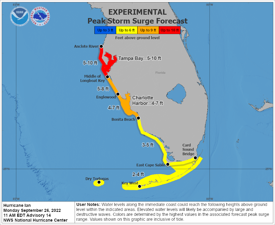
*Anclote River to Middle of Longboat Key, FL, including Tampa Bay…5-10 ft
*Middle of Longboat Key, FL to Englewood, FL…5-8 ft
*Englewood, FL to Bonita Beach, FL including Charlotte Harbor… 4-7 ft
*Bonita Beach, FL to East Cape Sable, FL…3-5 ft
*East Cape Sable, FL to Card Sound Bridge, FL including Florida Bay…2-4 ft
*Florida Keys including the Dry Tortugas…2-4 ft
The deepest water will occur along the immediate coast near and to the right of the center, where the surge will be accompanied by large waves. Surge-related flooding depends on the relative timing of the surge and the tidal cycle, and can vary greatly over short distances. For information specific to your area, please see products issued by your local National Weather Service forecast office.
Storm surge could raise water levels by as much as 9 to 14 feet above normal tide levels along the coast of western Cuba in areas of onshore winds in the hurricane warning area tonight and early Tuesday.
Storm surge could raise water levels by as much as 2 to 4 feet above normal tide levels along the immediate coast in areas of onshore winds in the Cayman Islands today.
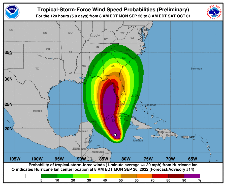
WIND: Tropical storm and hurricane conditions are expected on Grand Cayman today. Hurricane conditions are expected within the warning area in Cuba tonight, with tropical storm conditions expected by late today. Destructive winds are possible where the core of Ida moves across western Cuba.
Tropical storm conditions are expected within the tropical storm warning area in Cuba tonight and Tuesday. Tropical storm conditions are possible on Little Cayman and Cayman Brac today.
Hurricane conditions are possible along the west coast of Florida within the Hurricane Watch area on Wednesday, with tropical storm conditions possibly beginning by Tuesday night.
Tropical storm conditions are expected in the warning area in the lower Florida Keys and are possible in the watch area in the middle Florida Keys on Tuesday. Tropical storm conditions are possible within the watch area along the Florida west coast by Tuesday evening.
RAINFALL: Ian is expected to produce the following rainfall through Thursday:
Jamaica: An additional 1 to 3 inches, with a local maximum of 5 inches, especially along the south coastal region.
Cayman Islands: 3 to 6 inches, with local maxima up to 8 inches.
Western Cuba: 6 to 10 inches, with local maxima up to 16 inches.
These rains may produce flash flooding and mudslides in areas of higher terrain over western Cuba.
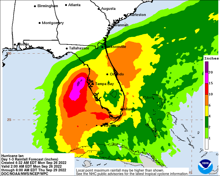
Florida Keys: 4 to 6 inches.
Central West Florida: 8 to 10 inches, with local maxima up to 15 inches.
Remainder of the Florida Peninsula: 3 to 8 inches.
Heavy rainfall is expected to affect North Florida, eastern portions of the Florida Panhandle, and portions of the Southeastern U.S. Friday and Saturday.
Widespread considerable flash and urban flooding and prolonged significant river flooding impacts are likely mid-to-late week in central Florida given already saturated conditions. Flash and urban flooding impacts are also possible with rainfall across the Florida Keys and the Florida peninsula through mid-week. Limited flooding impacts and rises on area streams and rivers are also possible over northern Florida and portions of the Southeast mid-to-late week.
TORNADOES: A few tornadoes are possible late tonight and Tuesday across the Florida Keys and the southern and central Florida Peninsula.
SURF: Swells generated by Ian are affecting Jamaica and the Cayman Islands. Swells will spread northwestward to the southwestern coast of Cuba and the coasts of Honduras, Belize, and the Yucatán Peninsula of Mexico today and tonight. Swells are expected to begin affecting the Florida Keys Tuesday and spread northward along the west coast of Florida through Wednesday. These swells are likely to cause life-threatening surf and rip current conditions. Please consult products from your local weather office.
Category: ALL POSTS, Severe Weather, Tropical
About the Author (Author Profile)
Scott Martin is an operational meteorologist, professional graphic artist, musician, husband, and father. Not only is Scott a member of the National Weather Association, but he is also the Central Alabama Chapter of the NWA president. Scott is also the co-founder of Racecast Weather, which provides forecasts for many racing series across the USA. He also supplies forecasts for the BassMaster Elite Series events including the BassMaster Classic.Subscribe
If you enjoyed this article, subscribe to receive more just like it.


