

Delightful Fall Weather Through Mid-Week; Some Weekend Rain Possible
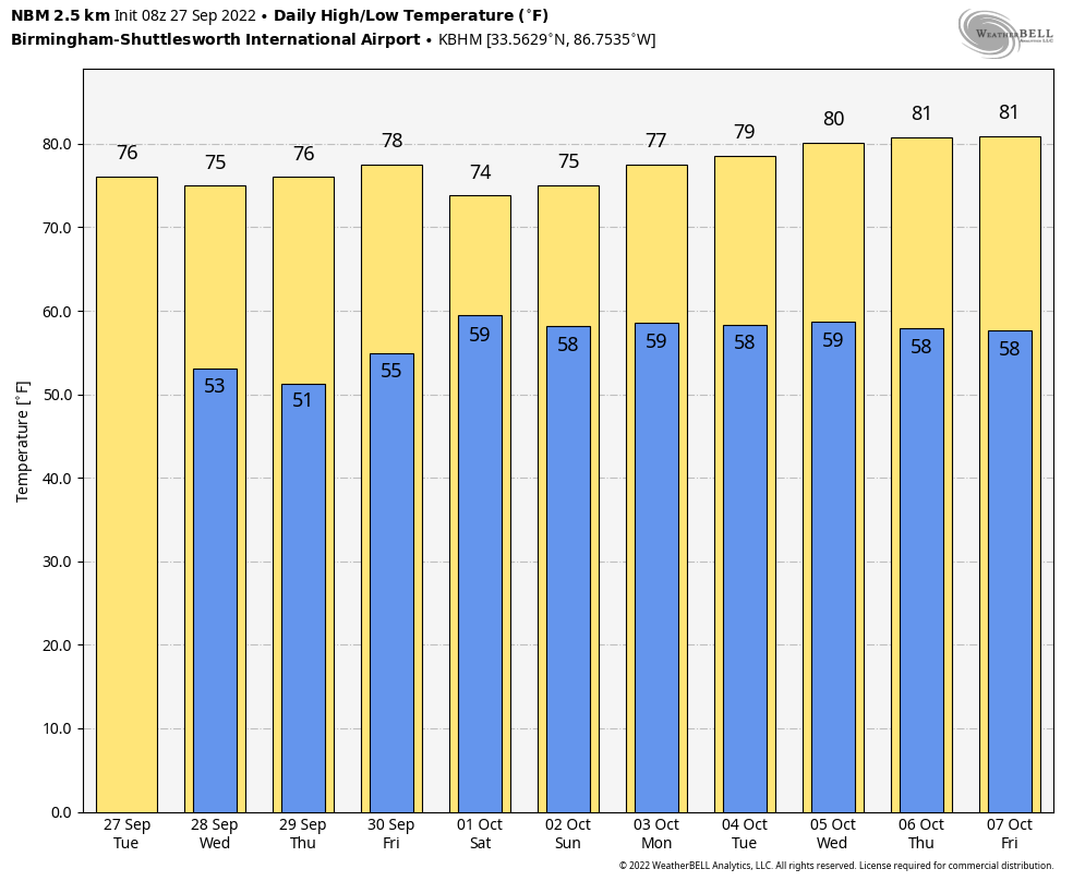
COOLEST SO FAR: Parts of North Alabama have dropped into the mid to upper 40s early this morning… it is our coolest morning so far this fall. Expect fantastic fall weather for the rest of the week with sunny pleasant days and clear cool nights. Highs in the mid to upper 70s, lows in the 40s and 50s through Friday.
ThE ALABAMA WEEKEND: Our weather will all depend on how Ian behaves once inland. For now, it looks like the best chance of rain Saturday and Saturday night will be over the eastern half of the state, with the heavier totals (over one inch) near the Georgia state line. Sunday looks mostly dry with just a few stray showers over the eastern counties. Highs over the weekend will be in the mid 70s.
NEXT WEEK: At this point the week looks dry and pleasant with highs around 80, and lows around 60 on most days. See the daily Weather Briefing video for maps, graphics, and more details.
FOOTBALL WEATHER: For most of the high school games in the state Friday night, for now the weather looks dry with temperatures falling through the 60s. Some rain can’t be ruled out over the southeast corner of Alabama.
Saturday, Alabama travels to Fayetteville to take on Arkansas (2:30p CT kickoff)… the sky will be sunny with temperatures in the low 80s as the game begins. No risk of rain.
Auburn hosts LSU Saturday evening (6:00p CT kickoff) at Jordan-hare Stadium. There is a high degree of uncertainty in the forecast due to the tropical system, but for now it looks like periods of rain are likely with temperatures hovering around 70 degrees during the game. A bit breezy, but the weather won’t be dangerous; just rain. Forecast confidence will increase as we approach the weekend.
UAB will be in Houston to take on Rice (6:30p CT kickoff)… the sky will be clear with temperatures falling from the low 80s at kickoff into the mid 70s by the final whistle.
RACE WEEKEND: Some rain is likely at times Saturday at Talladega, but it won’t rain all day. Then, Sunday looks generally dry with just a few isolated showers around. Highs will be in the mid 70s both days.
HURRICANE IAN NOTES…
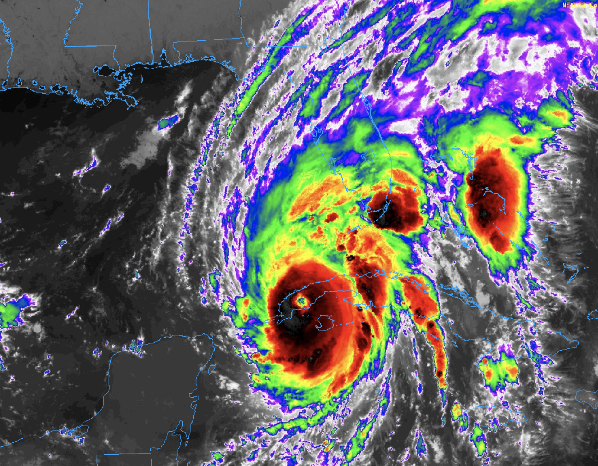
*Ian is now over the western tip of Cuba; winds have increased to 125 mph (a category three hurricane).
*The latest NHC forecast track brings Ian into the coast near or just north of Tampa Bay tomorrow night.
A Hurricane Warning is in effect for…
* Cuban provinces of Isla de Juventud, Pinar del Rio, and Artemisa
* Bonita Beach to the Anclote River, including Tampa Bay
* Dry Tortugas
A Storm Surge Warning is in effect for…
* Anclote River southward to Flamingo
* Tampa Bay
A Tropical Storm Warning is in effect for…
* Cuban provinces of La Habana, Mayabeque, and Matanzas
* Lower Florida Keys from Seven Mile Bridge westward to Key West
* Flamingo to Bonita Beach
* Suwannee River to the Anclote River
* Volusia/Brevard County Line south to Jupiter Inlet
* Lake Okeechobee
*The main impact from Ian will be over the Florida Peninsula, not the Panhandle.
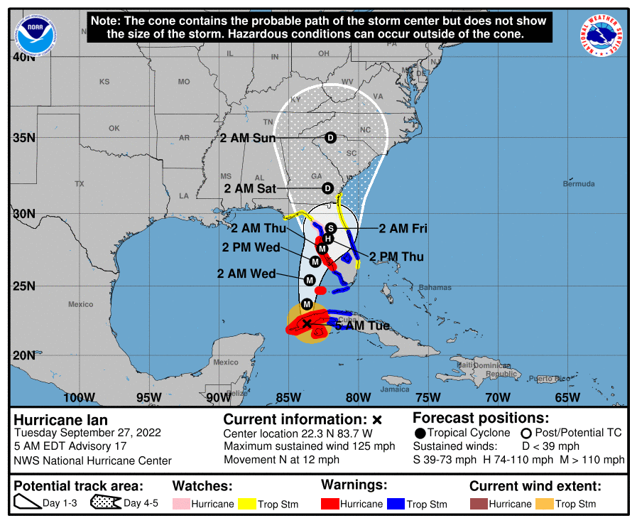
*Ian is expected to spend only spend a few hours over western Cuba, and little overall change in strength is likely during that time. The center should emerge over the southeastern Gulf of Mexico later this morning, where warm water and generally low vertical wind shear conditions are expected to allow for additional intensification, and the NHC forecast calls for Ian to reach category 4 strength. By 24 to 36 hours, increasing southwesterly vertical wind shear and drier mid-level air are likely to result in some gradual weakening. However, Ian is still expected to be a major hurricane when it reaches the Florida west coast near Tampa Bay.
*As Ian nears the Florida west coast, it will begin to move slower, and the wind field will be expanding.
*There is a danger of life-threatening storm surge along much of the Florida west coast where a storm surge warning has been issued, with the highest risk from Fort Myers to the Tampa Bay region. Residents in these areas should listen to advice given by local officials.
*Hurricane-force winds are expected in the hurricane warning area in west-central Florida beginning tomorrow morning with tropical storm conditions expected by late today.
*Heavy rainfall will increase across the Florida Keys and South Florida today, spreading into central to northern Florida tomorrow and Thursday, and the Southeast by Friday and Saturday, likely causing flash, urban, and small stream flooding. Considerable flooding is expected across Central Florida into southern Georgia and coastal South Carolina, with significant, prolonged river flooding expected across central to northern Florida.
*Alabama and the Central Gulf Coast (Gulf Shores to Panama City Beach) will be on the dry, offshore flow side of the circulation (the west side with a north wind). Some rain is certainly possible for places like Destin and Panama City Beach Friday, but the weather won’t be dangerous there.
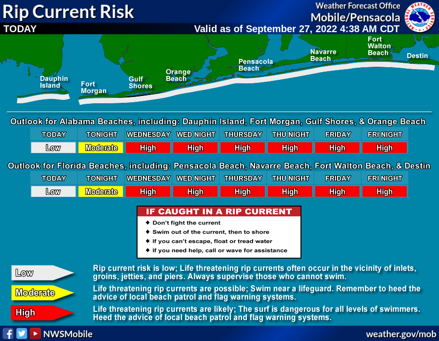
*Even though the hurricane will be well to the east, the surf will be very rough along the Central Gulf Coast this week (Gulf Shores to Panama City Beach), with high rip current danger over the latter half of the week. Expect double red flags by Wednesday.
*Remember, when you are using old information when it comes to tropical systems, you are working with bad information. Keep watching for updates.
ON THIS DATE IN 1906: The second September storm of 1906 was one of great violence. On the 27th the hurricane reached the central Gulf Coast with destructive winds and unprecedented tides. At Pensacola the tide was 10 feet above normal. At Mobile, property damage was severe. An estimated 134 lives were lost from Pensacola to Mississippi from this storm.
ON THIS DATE IN 1985: Hurricane Gloria swept over the Outer Banks then rushed across Long Island, New England, and Canada. It was the first significant hurricane to hit New England in twenty-five years and brought heavy rains and high winds to the Mid-Atlantic states as well.
BEACH FORECAST: Click here to see the AlabamaWx Beach Forecast Center page.
Look for the next Weather Briefing video here by 3:00 this afternoon… enjoy the day!
Category: Alabama's Weather, ALL POSTS, Weather Xtreme Videos
About the Author (Author Profile)
James Spann is one of the most recognized and trusted television meteorologists in the industry. He holds the AMS CCM designation and television seals from the AMS and NWA. He is a past winner of the Broadcast Meteorologist of the Year from both professional organizations.Subscribe
If you enjoyed this article, subscribe to receive more just like it.


