

10 am Ian Update: Eye of Powerful Hurricane Emerges Over Gulf of Mexico
SUMMARY OF 1000 AM CDT…1500 UTC…INFORMATION
———————————————–
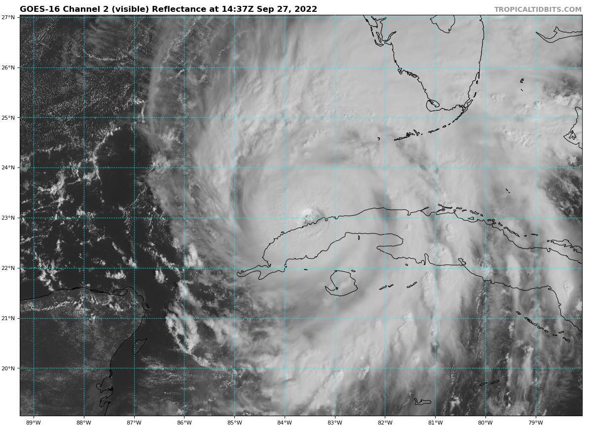
LOCATION…23.0N 83.5W
ABOUT 305 MI…490 KM SSW OF SARASOTA FLORIDA
ABOUT 125 MI…200 KM SSW OF THE DRY TORTUGAS
MAXIMUM SUSTAINED WINDS…115 MPH…185 KM/H
PRESENT MOVEMENT…N OR 5 DEGREES AT 10 MPH…17 KM/H
MINIMUM CENTRAL PRESSURE…963 MB…28.44 INCHES
WATCHES AND WARNINGS
——————–
A Hurricane Warning is in effect for…
* Cuban provinces of Isla de Juventud, Pinar del Rio, and Artemisa
* Bonita Beach to Anclote River, including Tampa Bay
* Dry Tortugas
A Storm Surge Warning is in effect for…
* Suwanee River southward to Flamingo
* Tampa Bay
* Dry Tortugas
* Marineland to the mouth of the St. Mary’s River
* St. Johns River
A Tropical Storm Warning is in effect for…
* Cuban provinces of La Habana, Mayabeque, and Matanzas
* Suwannee River to the Anclote River
* Flamingo to Bonita Beach
* Lower and Middle Florida Keys
* Boca Raton to Altamaha Sound
* Lake Okeechobee
A Storm Surge Watch is in effect for…
* Florida Keys from the Card Sound Bridge westward to Key West
* Florida Bay
* Aucilla River to Suwanee River
* Mouth of St. Mary’s River to South Santee River
* South of Marineland to the Volusia/Flagler county line
A Hurricane Watch is in effect for…
* North of Anclote River to Suwannee River
* South of Bonita Beach to Chokoloskee
A Tropical Storm Watch is in effect for…
* North of Suwannee River to Indian Pass
* North of Altamaha Sound to South Santee River
* South of Boca Raton to east of Flamingo
* Upper Florida Keys
* Florida Bay
DISCUSSION AND OUTLOOK
———————-
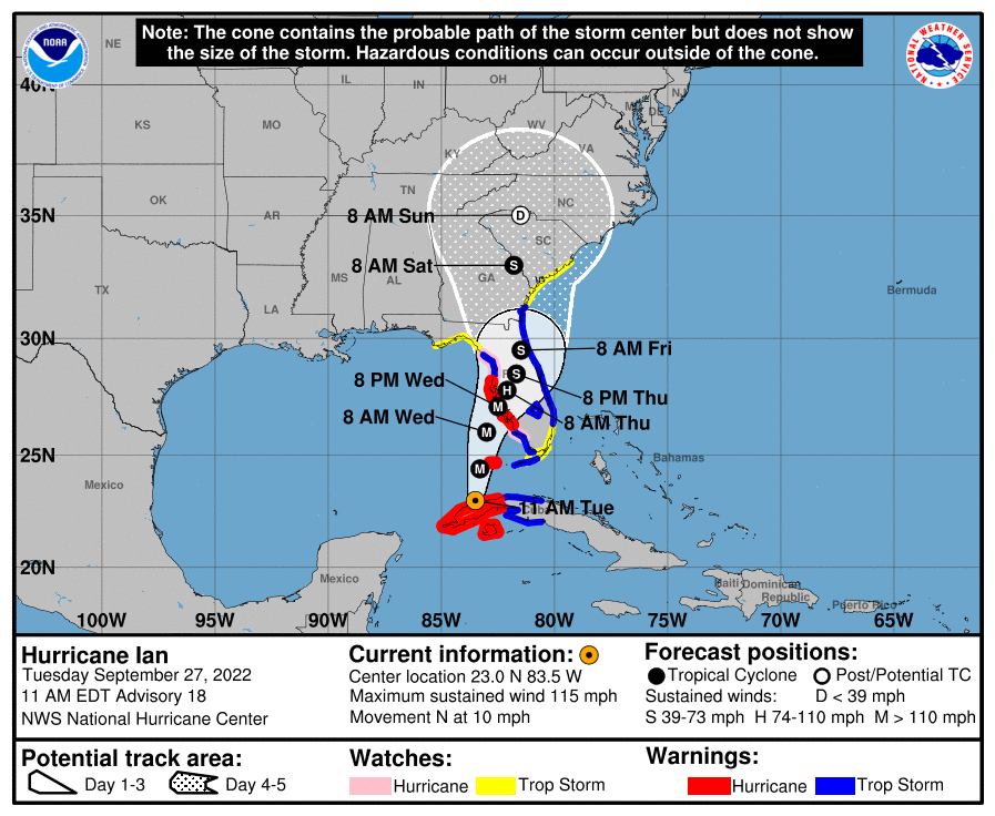
At 1000 AM CDT (1500 UTC), the center of Hurricane Ian was located near latitude 23.0 North, longitude 83.5 West. Ian is moving toward the north near 10 mph (17 km/h), and this motion is expected to continue today. A turn toward the north-northeast with a reduction in forward speed is forecast tonight and Wednesday. On the forecast track, the center of Ian is expected to move over the southeastern Gulf of Mexico in a couple of hours, pass west of the Florida Keys later today, and approach the west coast of Florida within the hurricane warning area on Wednesday and Wednesday night.
Maximum sustained winds are near 115 mph (185 km/h) with higher gusts. Ian is a category 3 hurricane on the Saffir-Simpson Hurricane Wind Scale. Re-strengthening is expected later today through Wednesday. Ian is forecast to approach the west coast of Florida as an extremely dangerous major hurricane. Hurricane-force winds extend outward up to 35 miles (55 km) from the center and tropical-storm-force winds extend outward up to 140 miles (220 km). The estimated minimum central pressure is 963 mb (28.44 inches) based on Air Force Hurricane Hunter data.
HAZARDS AFFECTING LAND
———————-
STORM SURGE: The combination of storm surge and the tide will cause normally dry areas near the coast to be flooded by rising waters moving inland from the shoreline. The water could reach the following heights above ground somewhere in the indicated areas if the peak surge occurs at the time of high tide…
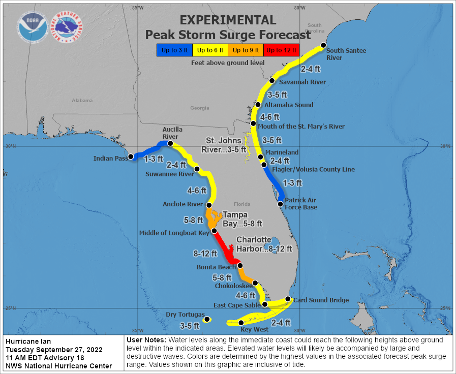
* Middle of Longboat Key to Bonita Beach, including Charlotte Harbor…8-12 ft
* Bonita Beach to Chokoloskee…5-8 ft
* Anclote River to Middle of Longboat Key, including Tampa Bay…5-8 ft
* Suwannee River to Anclote River…4-6 ft
* Mouth of the St. Mary’s River to Altamaha Sound…4-6 ft
* Chokoloskee to East Cape Sable…4-6 ft
* Dry Tortugas…3-5 ft
* Marineland to Mouth of the St. Mary’s River, including St. Johns River…3-5 ft
* Altamaha Sound to Savannah River…3-5 ft
* St. Johns River south of Julington…2-4 ft
* Savannah River to South Santee River…2-4 ft
* Flagler/Volusia County Line to Marineland…2-4 ft
* East Cape Sable to Card Sound Bridge…2-4 ft
* Aucilla River to Suwannee River…2-4 ft
* Patrick Air Force Base to Flagler/Volusia County Line…1-3 ft
* Indian Pass to Aucilla River…1-3
The deepest water will occur along the immediate coast near and tothe right of the center, where the surge will be accompanied by large waves. Surge-related flooding depends on the relative timing of the surge and the tidal cycle, and can vary greatly over short distances. For information specific to your area, please see products issued by your local National Weather Service forecast office.
Storm surge could raise water levels by as much as 4 to 6 feet above normal tide levels along the coast of western Cuba in areas of onshore winds in the hurricane warning area early today.
WIND: Hurricane conditions are expected within the warning area in Cuba through early afternoon, with destructive winds likely for a few more hours. Tropical storm conditions are expected within the tropical storm warning area in Cuba today.
Hurricane conditions are expected along the west coast of Florida within the Hurricane Warning area on Wednesday morning, with tropical storm conditions possibly beginning by late today. Tropical storm conditions are expected in the Tropical Storm Warning area along the southwest coast of the Florida peninsula by this evening, and along the west coast north of the Tampa Bay area and along portions of the east coast of Florida on Wednesday. Hurricane conditions are possible in the watch area beginning on Wednesday.
Tropical storm conditions are expected in the warning area in the lower and middle Florida Keys beginning later today, and are possible in southeastern Florida in the Tropical Storm Watch area beginning this evening. Tropical storm conditions are expected in the Tropical Storm Warning area on the east coast of Florida beginning early Wednesday, spreading up to Georgia and South Carolina on Thursday. Tropical storm conditions are possible in the Tropical Storm Watch area in the Florida Big Bend area on Wednesday into early Thursday.
RAINFALL: Ian is expected to produce the following rainfall through Thursday night:
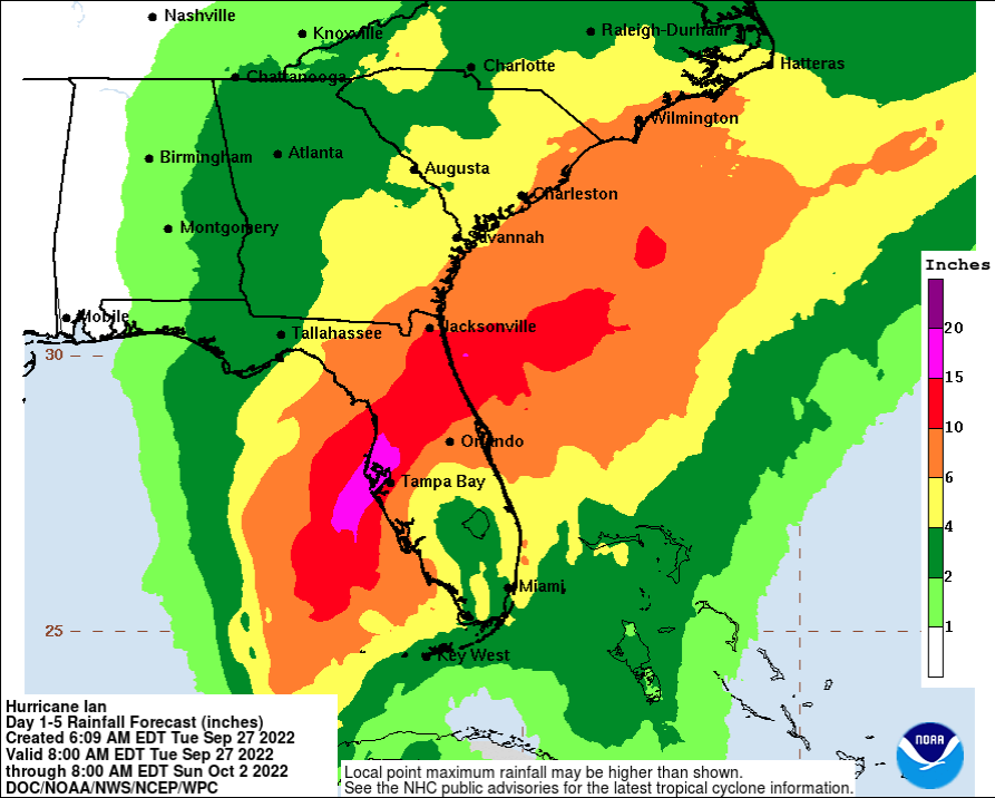
* Western Cuba: 6 to 12 inches, with isolated totals up to 16 inches. These rains may produce flash flooding and mudslides in areas of higher terrain over western Cuba.
* Florida Keys and South Florida: 4 to 6 inches, with isolated totals up to 8 inches.
* Central West Florida: 12 to 16 inches, with isolated totals up to 24 inches.
* Northeast Florida and the remainder of the Central Florida Peninsula: 5 to 10 inches, with isolated totals up to 12 inches.
* Heavy rainfall is expected to affect the southeastern United States Friday and Saturday.
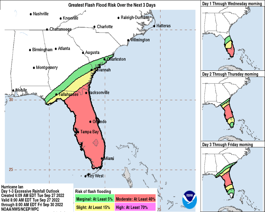
Widespread considerable flash and urban flooding are expected mid-to-late week across central and northern Florida, southern Georgia, and coastal South Carolina, with significant, prolonged river flooding expected across central to northern Florida. Flash and urban flooding are also expected with rainfall across southern Florida through mid week. Limited flash and river flooding is expected over portions of the southeastern United States into the Mid-Atlantic mid-to-late week.
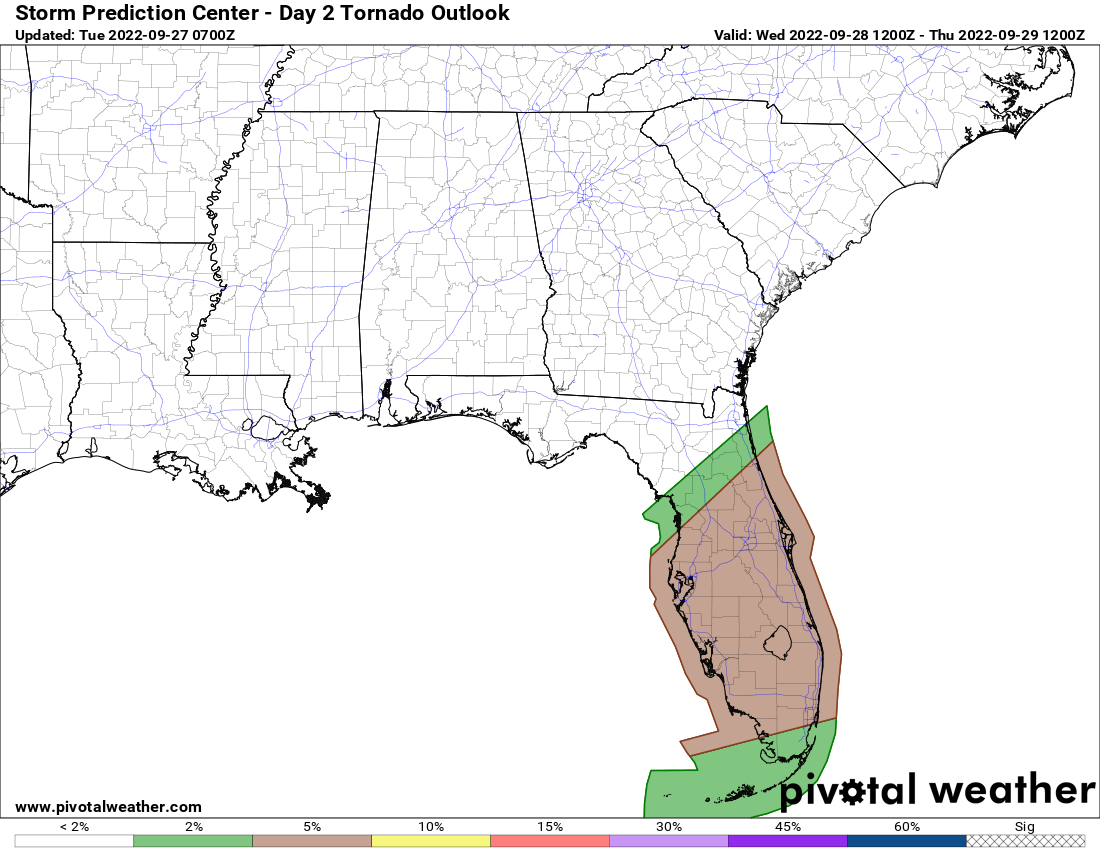
TORNADOES: Tornadoes are possible today through Wednesday across the Florida Keys and the southern and central Florida Peninsula.
SURF: Swells generated by Ian are affecting the western Caribbean, and the Florida Keys, and will spread northward throughout the eastern Gulf of Mexico tonight and Wednesday. These swells are likely to cause life-threatening surf and rip current conditions. Please consult products from your local weather office.
Category: ALL POSTS, Severe Weather, Tropical
About the Author (Author Profile)
Scott Martin is an operational meteorologist, professional graphic artist, musician, husband, and father. Not only is Scott a member of the National Weather Association, but he is also the Central Alabama Chapter of the NWA president. Scott is also the co-founder of Racecast Weather, which provides forecasts for many racing series across the USA. He also supplies forecasts for the BassMaster Elite Series events including the BassMaster Classic.Subscribe
If you enjoyed this article, subscribe to receive more just like it.


