

Most Of Alabama Stays Dry Through Next Week
ANOTHER COOL START: Here are some temperatures across Alabama early this morning just before sunrise…
Gadsden 42
Cullman 43
Pell City 43
Trussville 43
Haleyville 44
Scottsboro 45
Hueytown 46
Helena 47
Good Hope 47
Sylacauga 47
Huntsville 49
Demopolis 49
Tuscaloosa 52
Montgomery 53
Anniston 53
Muscle Shoals 56
Mobile 57
Dothan 58
Birmingham 59
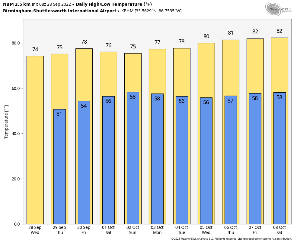
Look for dry weather to continue through Friday with sunny pleasant days and fair cool nights; highs will be in the mid to upper 70s.
THE ALABAMA WEEKEND: It now looks like the rain shield associated with Ian will stay east of Alabama. Some rain is possible Saturday near the Georgia border, but most of the state will be dry with a partly to mostly sunny sky… the high will be in the mid to upper 70s with a north breeze. Sunday will be another dry day with a high in the mid 70s.
NEXT WEEK: The long dry spell continues; look for mostly sunny days and fair nights. Highs between 78 and 82; lows in the upper 50s and low 60s most mornings. See the daily Weather Briefing video for maps, graphics, and more details.
FOOTBALL WEATHER: For the high school games in the state Friday night, the sky will be mostly clear with temperatures falling through the 60s.
Saturday, Alabama travels to Fayetteville to take on Arkansas (2:30p CT kickoff)… the sky will be sunny with temperatures in the low 80s as the game begins. No risk of rain.
Auburn hosts LSU Saturday evening (6:00p CT kickoff) at Jordan-hare Stadium. Just a small risk of some light rain; the sky will be mostly cloudy with temperatures falling from near 75 at kickoff, into the upper 60s by the final whistle.
UAB will be in Houston to take on Rice (6:30p CT kickoff)… the sky will be clear with temperatures falling from the low 80s at kickoff into the mid 70s by the final whistle.
RACE WEEKEND: Just a small risk of a shower at Talladega Saturday, otherwise it will be a partly sunny day with a high between 75 and 78 degrees. Sunday is looking dry with a partly sunny sky along with a high in the mid 70s. The big rain shield associated with Ian will stay east of Alabama.
MORNING NOTES ON HURRICANE IAN…
WEDNESDAY MORNING NOTES ON HURRICANE IAN…
*Ian is now an extremely dangerous category four hurricane with winds of 140 mph. The center is about 85 miles west/southwest of Naples.

A Hurricane Warning is in effect for…
* Chokoloskee to Anclote River, including Tampa Bay
* Dry Tortugas
A Storm Surge Warning is in effect for…
* Suwannee River southward to Flamingo
* Tampa Bay
* Lower Florida Keys from Big Pine Key westward to Key West
* Dry Tortugas
* Flagler/Volusia Line to the mouth of the St. Mary’s River
* St. Johns River
A Tropical Storm Warning is in effect for…
* Cuban provinces of La Habana, Mayabeque, and Matanzas
* Indian Pass to the Anclote River
* All of the Florida Keys
* Flamingo to South Santee River
* Flamingo to Chokoloskee
* Lake Okeechobee
* Florida Bay
* Bimini and Grand Bahama Islands
*Some fluctuations in intensity are possible before the center reaches the coast later today, but Ian is expected to reach the coast as an extremely dangerous category 4 hurricane. Weakening is expected while Ian moves over the Florida peninsula.
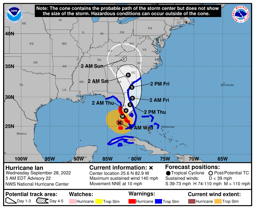
*Life-threatening storm surge is expected along the Florida west coast and the Lower Florida Keys where a storm surge warning is in effect, with the highest risk from Naples to the Sarasota region. Residents in these areas should listen to advice given by local officials and follow any evacuation orders for your area.
*Hurricane-force winds are expected in the hurricane warning area in southwest and west-central Florida beginning Wednesday morning with tropical storm conditions expected overnight. Catastrophic wind damage is expected near the core of Ian when it moves onshore.
*Heavy rainfall will spread across the Florida peninsula through Thursday and reach portions of the Southeast later this week and this weekend. Widespread, life-threatening catastrophic flooding is expected across portions of central Florida with considerable flooding in southern Florida, northern Florida, southeastern Georgia and coastal South Carolina. Widespread, prolonged major and record river flooding expected across central Florida.
*Tornadoes are possible today and tonight across central and south Florida.
ON THIS DATE IN 1998: Hurricane Georges made landfall near Biloxi with maximum winds of 110mph and a minimum pressure of 964 mb. After landfall, Georges moved very slowly across southern Mississippi and weakened to a tropical depression by the morning of the 29th when the center was about 30 miles north northeast of Mobile. There was one fatality reported in the mainland United States directly related to the hurricane. That lone fatality occurred in Mobile due to freshwater flooding. In Escambia County, FL, there were 3 fatalities indirectly related to Georges. Insured property damage was estimated to have cost 2.955 billion dollars in Florida, Alabama, Mississippi, and Louisiana. Throughout the area, agriculture took a beating with the cotton, soybean and pecan crop almost totally destroyed.
BEACH FORECAST: Click here to see the AlabamaWx Beach Forecast Center page.
Look for the next Weather Xtreme video here by 3:00 this afternoon… enjoy the day!
Category: Alabama's Weather, ALL POSTS, Weather Xtreme Videos
About the Author (Author Profile)
James Spann is one of the most recognized and trusted television meteorologists in the industry. He holds the AMS CCM designation and television seals from the AMS and NWA. He is a past winner of the Broadcast Meteorologist of the Year from both professional organizations.Subscribe
If you enjoyed this article, subscribe to receive more just like it.


