

Julia Strengthens Into a Hurricane; Heading for the Coast of Nicaragua
CENTER OF JULIA PASSING SAN ANDRES AND HEADING FOR THE COAST OF NICARAGUA.
LIFE-THREATENING FLASH FLOODS AND MUDSLIDES POSSIBLE FROM HEAVY RAINS OVER CENTRAL AMERICA AND SOUTHERN MEXICO THROUGH EARLY NEXT WEEK.
SUMMARY OF 800 PM EDT…0000 UTC…INFORMATION
———————————————-
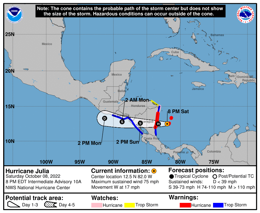
LOCATION…12.5N 82.0W
ABOUT 20 MI…30 KM WSW OF SAN ANDRES ISLAND COLOMBIA
ABOUT 125 MI…200 KM ENE OF BLUEFIELDS NICARAGUA
MAXIMUM SUSTAINED WINDS…75 MPH…120 KM/H
PRESENT MOVEMENT…W OR 270 DEGREES AT 17 MPH…28 KM/H
MINIMUM CENTRAL PRESSURE…989 MB…29.20 INCHES
WATCHES AND WARNINGS
——————–
A Hurricane Warning is in effect for…
* San Andres, Providencia, and Santa Catalina Islands Colombia
* Nicaragua from Bluefields to Puerto Cabezas
A Hurricane Watch is in effect for…
* Nicaragua north of Puerto Cabezas to the Honduras/Nicaragua border
A Tropical Storm Warning is in effect for…
* Nicaragua south of Bluefields to the Nicaragua/Costa Rica border
* Nicaragua north of Puerto Cabezas to the Honduras/Nicaragua border
* Pacific coast of Nicaragua
* Pacific coast of Honduras
* Coast of El Salvador
A Tropical Storm Watch is in effect for…
* Honduras from the Nicaragua/Honduras border to Punta Patuca
DISCUSSION AND OUTLOOK
———————-
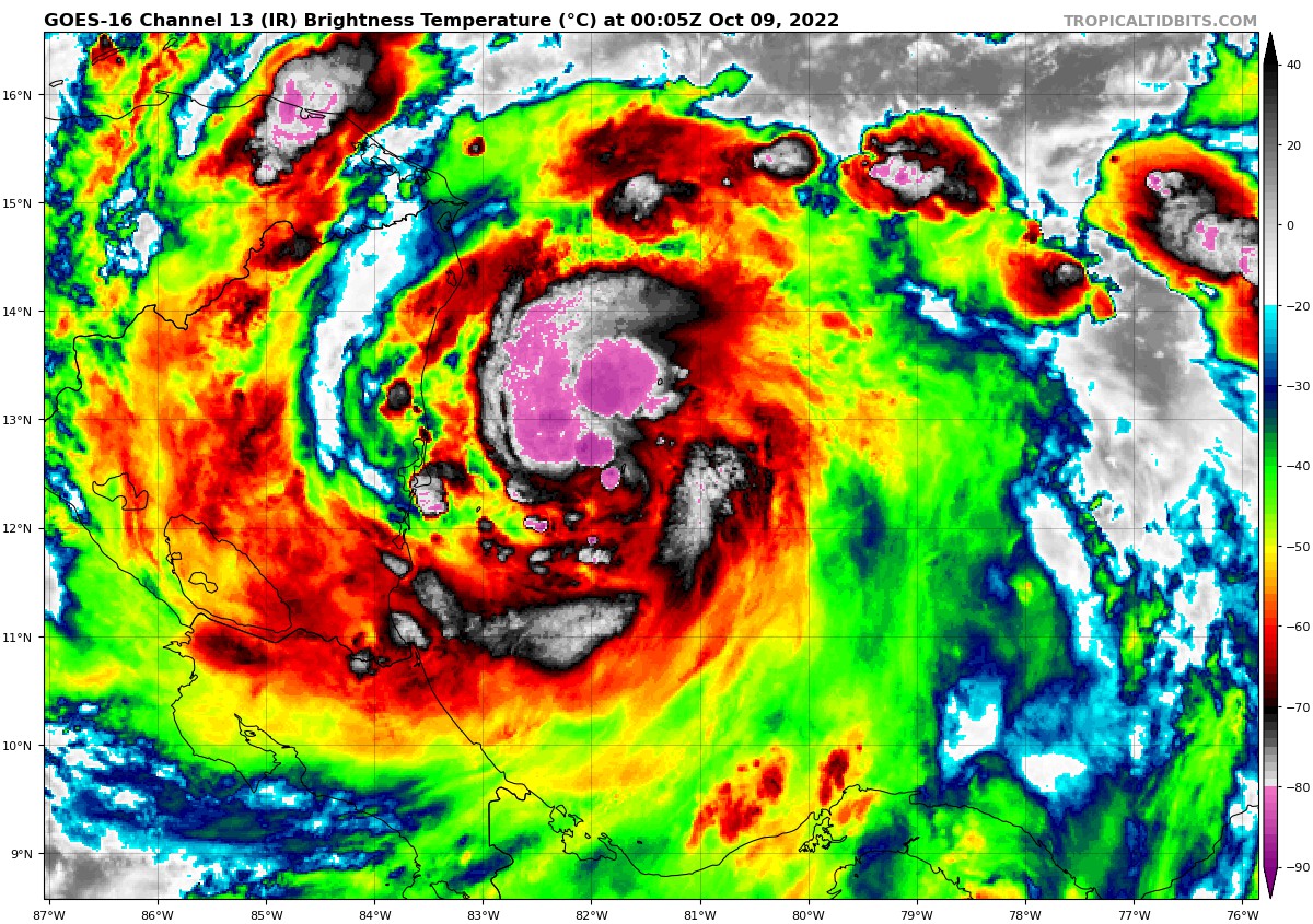
At 800 PM EDT (0000 UTC), the center of Hurricane Julia was located near latitude 12.5 North, longitude 82.0 West. Julia is moving toward the west near 17 mph (28 km/h). A continued westward motion with some decrease in forward speed is expected during the next couple of days. On the forecast track, the center of Julia is expected to reach the coast of Nicaragua overnight, move across Nicaragua on Sunday, and then move near or along the Pacific coasts of Honduras, El Salvador, and Guatemala through Monday.
Maximum sustained winds are near 75 mph (120 km/h) with higher gusts. Strengthening is forecast until landfall in Nicaragua. Weakening is expected once Julia moves inland, but it is forecast to still be a tropical storm when it moves off the Pacific coast of Nicaragua late Sunday. Julia should weaken to a tropical depression on Monday and dissipate by Monday night.
Hurricane-force winds extend outward up to 30 miles (50 km) from the center, while tropical-storm-force winds extend outward up to 115 miles (185 km) from the center. The minimum central pressure estimated from NOAA Hurricane Hunter aircraft data is 989 mb (29.20 inches).
HAZARDS AFFECTING LAND
———————-
WIND: Hurricane conditions are occurring on the Colombian islands of San Andres, Providencia, and Santa Catalina. Hurricane conditions are expected along the coast of Nicaragua within the hurricane warning area overnight and early Sunday morning, with tropical storm conditions beginning during the next several hours. Hurricane conditions are possible along the coast of Nicaragua within the hurricane watch area early Sunday morning.
Tropical storm conditions are expected along the Caribbean coast of Nicaragua within the tropical storm warning areas by tonight or early Sunday. Tropical storm conditions are possible along the coast of Honduras within the watch area tonight.
Tropical storm conditions are expected along the Pacific coasts of Nicaragua, Honduras, and El Salvador Sunday afternoon into Sunday night.
RAINFALL: Julia is expected to produce the following rainfall accumulations through early Tuesday:
San Andres and Providencia…6 to 12 inches.
Nicaragua…5 to 10 inches, isolated 15 inches.
Remainder of Central America…4 to 8 inches, isolated 12 inches.
Isthmus of Tehuantepec in Mexico…2 to 4 inches, isolated 6 inches.
This rainfall may cause life-threatening flash floods and mudslides through this weekend. Flash flooding is possible across the Isthmus of Tehuantepec in Mexico early next week.
STORM SURGE: A storm surge is likely to raise water levels by as much as 2 to 4 feet above normal tide levels along the immediate coast in areas of onshore winds on San Andres, Providencia, and Santa Catalina Islands. Near the coast, the surge will be accompanied by large and damaging waves.
A storm surge is likely to raise water levels by as much as 4 to 6 feet above normal tide levels along the immediate coast of Nicaragua in areas of onshore winds. Large and damaging waves will likely accompany the storm surge near the coast.
SURF: Swells generated by Julia are affecting Jamaica, Providencia, and San Andres, and will reach portions of the coast of Central America this evening into Sunday. These swells are likely to cause life-threatening surf and rip current conditions. Please consult products from your local weather office.
Category: ALL POSTS, Severe Weather, Tropical
About the Author (Author Profile)
Scott Martin is an operational meteorologist, professional graphic artist, musician, husband, and father. Not only is Scott a member of the National Weather Association, but he is also the Central Alabama Chapter of the NWA president. Scott is also the co-founder of Racecast Weather, which provides forecasts for many racing series across the USA. He also supplies forecasts for the BassMaster Elite Series events including the BassMaster Classic.Subscribe
If you enjoyed this article, subscribe to receive more just like it.


