

Midday Nowcast: Strong Storms Expected this Afternoon
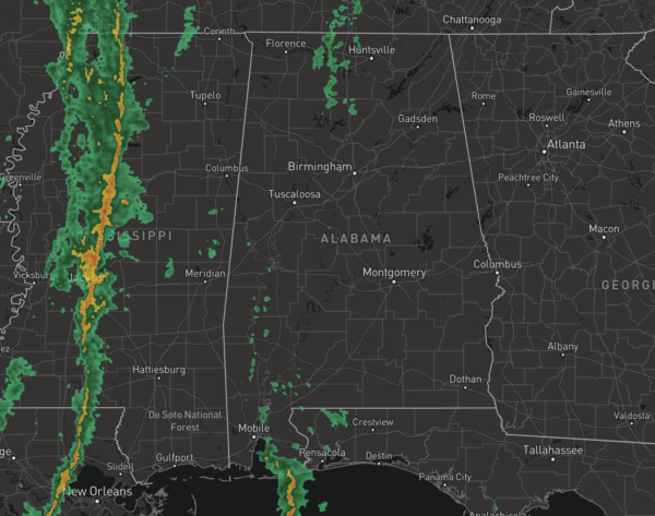
We are watching the radar this afternoon as strong to severe storms are possible as a storm system moves across the Southeast. We are seeing increasing clouds and breezy southerly winds of 15-35 mph, a wind advisory is in effect for much of North Alabama today. Some showers have been ongoing through the morning hours, but we are watching a line of storms move in from the west.
All of Alabama is included in a risk of severe storms today and the SPC maintains a “slight risk” (level 2/5) for much of North, Central, and West Alabama, and a “marginal risk” (level 1/5) for the rest of the state (the eastern counties).
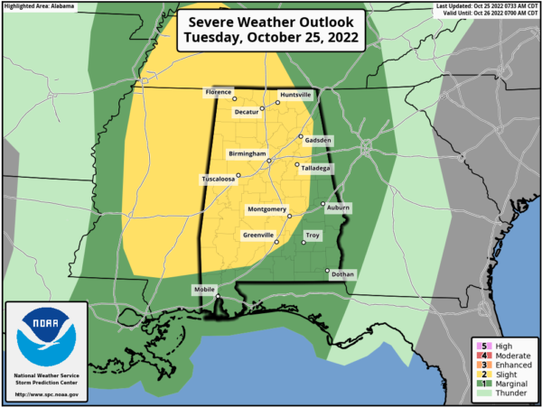
Now through about 8PM is when we will be dealing with the storms. First in West Alabama early this afternoon, then exiting the state later this evening as a weakening line. The higher severe weather probabilities are over the western half of the state, but again, all of Alabama is highlighted in a risk.
Stronger storms will be capable of producing damaging wind gusts, and some hail. A few tornadoes are possible, especially over the western half of the state. Rain amounts of one-half inch to one inch are likely across the northern half of the state, with lower amounts to the south. We certainly need the rain, and many locations should at least get enough to settle the dust.
BE READY: It has been a while since we have had a severe weather threat. Be sure you can hear severe weather warnings if they are needed later today. A NOAA Weather Radio is the baseline for every home and business…and be sure WEA (Wireless Emergency Alerts) are enabled on your phone. Install the free ABC 33/40 Weather app. Know the safe place in your home (lowest floor, near the center of the house, away from windows), and have helmets for everyone there. If you live in a mobile home, know the location of the nearest shelter or site built structure that is available, how to get there quickly, and have transportation.
No need to be anxious, these setups are common in Alabama during our tornado season, which runs from November through May. Hopefully we will get though the event with no major problems, but you have to be ready in case you fall in a tornado warning polygon.
COOLER/DRIER: This system is in and out of here quickly, and by tomorrow dry weather returns to the state Wednesday through Friday. Expect plenty of sunshine and cooler temperatures with highs Wednesday in the upper 60s, followed by low to mid 70s Thursday and Friday.
WEEKEND WEATHER: Rain returns to the state this weekend. On Saturday, clouds will increase and a few spotty showers are possible with highs in the upper 60s. Sunday will be a cloudy day with periods of rain, and highs in the mid 60s. No risk of severe storms over the weekend, and probably very little thunder with basically no surface based instability. Again, we need the rain, so we will take it whenever we can get it.
NEXT WEEK: Showers could linger into the day Monday, but at this point it looks like the rain will be over by trick or treat time Monday night. Mid-week looks dry, followed by another chance of rain by Thursday night or Friday. Highs will be in the 70s through much of the week…
TROPICS: NHC is monitoring three waves in the Atlantic. For now they are not too concerning, but we will keep an eye on them…the Gulf of Mexico remains quiet. Hurricane season ends November 30th and the next names up are Lisa, Martin, and Nicole.

BEACH FORECAST CENTER: Get the latest weather and rip current forecasts for the beaches from Fort Morgan to Panama City on our Beach Forecast Center page. There, you can select the forecast of the region that you are interested in visiting.
WORLD TEMPERATURE EXTREMES: Over the last 24 hours, the highest observation outside the U.S. was 115.0F at Lorca, Spain. The lowest observation was -75.5F at Dome A, Antarctica.
CONTIGUOUS TEMPERATURE EXTREMES: Over the last 24 hours, the highest observation was 99F at Falcon Lake, TX. The lowest observation was 1F at Baker, NV.
Category: Alabama's Weather, ALL POSTS, Severe Weather
About the Author (Author Profile)
Macon, Georgia Television Chief Meteorologist, Birmingham native, and long time Contributor on AlabamaWX. Stormchaser. I did not choose Weather, it chose Me. College Football Fanatic. @Ryan_StinnetSubscribe
If you enjoyed this article, subscribe to receive more just like it.


