

SPC Says Tornado Watch Possible Later for Alabama
The Storm Prediction Center has issued a Mesoscale Convective Discussion, which outlines their thinking in how a severe weather situation will develop.
The basic gist is that a line of thunderstorms that is now east of I-55 in Mississippi will continue pushing eastward through the afternoon and evening. Our best timing on it right now is like this:
Starkville 130-145 pm
Meridian 1:05-1:20 pm
Into western Alabama around Aliceville by 215-230 pm
Tuscaloosa 345-4 pm
Birmingham 530-545 pm
Pell City by 7 pm
These storms will encounter increasing instability as they push eastward during the best heating of the day. Although cloud cover has been heavy, there have been breaks in the clouds that have allowed temperatures over western Alabama to get into the 70s. Dewpoints have increased rapidly over West Alabama as well, with readings of 67F at Demopolis and 65F at Tuscaloosa. This is sufficient moisture for strong to severe storms.
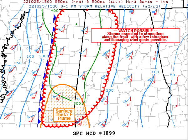
CAPE values will climb to between 500 and 1,000 joules/kg over western portions of the area before the storms arrive. This is sufficient for strong to severe storms when combined with decent wind shear. There will be plenty of speed shear, with effective shear values in the 45-60 knot range, and low level shear could be maximized in spots, reaching 200-300 m2s2, generating Significant Tornado Parameter values over 2, indicating the possibility of a couple of brief tornadoes, including the potential for a strong tornado.
There is a low-end tornado threat for much of the western half of North and Central Alabama, west of a line from Decatur to Brent to Thomasville, with the highest threat from parts of Pickens and Tuscaloosa counties over into Bibb and Shelby counties, and points south.
The hail threat is fairly low, but any discrete supercells that form could result in severe hail to the size of quarters. Damaging winds is the bigger threat with a low level jet developing into the afternoon over western Alabama which could result in gusts of 60 mph.
Winds will be increasing at the surface this afternoon, averaging 10-20 mph and gusting to 30 mph at times outside of thunderstorms. Secure outdoor objects that might be blown about. Wind advisories are in effect until later this evening.
Here is the text of the discussion from the SPC:
Mesoscale Discussion 1899
NWS Storm Prediction Center Norman OK
1121 AM CDT Tue Oct 25 2022
Areas affected…much of eastern Mississippi into western and
northern Alabama
Concerning…Severe potential…Watch possible
Valid 251621Z – 251845Z
Probability of Watch Issuance…60 percent
SUMMARY…Storms are expected to gradually increase in intensity
along a cold front, with sporadic wind damage and couple tornadoes
possible.
DISCUSSION…A north-south oriented line of storms currently extends
from the MO Bootheel into western TN, and due south across the
middle of MS. While northern parts of this line are surging quickly
northeastward coincident with the shortwave trough, southern
portions of the line are moving slower toward the east. Recently,
lightning has been observed over central MS where MLCAPE remains
below 1000 J/kg.
Surface observations show warming over southern MS with temperatures
in the upper 70s to near 80 F, and this degree of warming may be
needed for surface-based inflow parcels initially.
With time, a few cells along the front may become severe, with
sections of QLCS possible. Large scale lift is more favorable
farther north, but low-level convergence along the front should be
enough to initiate new storms later today given robust moisture.
Large looping hodographs with 0-1 SRH to 300 m2/s2 will clearly
favor rotation, with a conditional threat of brief tornadoes and
corridors of damaging winds.
The slow eastward movement of the line, coupled with diurnal
considerations, do appear favorable for a discrete supercell or two
later this afternoon, most notably where southern portions of the
line interact with the stronger MLCAPE. Though models differ on
storm coverage, any discrete supercells in this high shear
environment could result in an isolated strong tornado within a
relatively narrow zone.
..Jewell/Guyer.. 10/25/2022
Category: Alabama's Weather, ALL POSTS, Severe Weather
About the Author (Author Profile)
Bill Murray is the President of The Weather Factory. He is the site's official weather historian and a weekend forecaster. He also anchors the site's severe weather coverage. Bill Murray is the proud holder of National Weather Association Digital Seal #0001 @wxhistorianSubscribe
If you enjoyed this article, subscribe to receive more just like it.


