

Nicole Close to Hurricane Strength & Headed for the Northwest Bahamas
SUMMARY OF 1000 PM EST…0300 UTC…INFORMATION
———————————————–
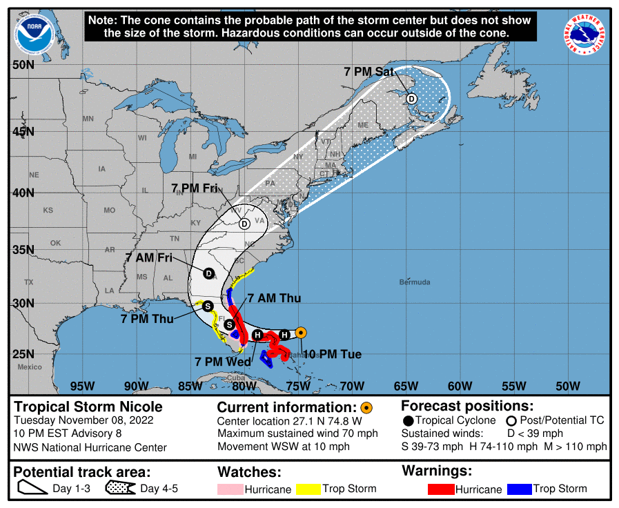
LOCATION…27.1N 74.8W
ABOUT 150 MI…240 KM ENE OF GREAT ABACO ISLAND
ABOUT 325 MI…525 KM E OF WEST PALM BEACH FLORIDA
MAXIMUM SUSTAINED WINDS…70 MPH…110 KM/H
PRESENT MOVEMENT…WSW OR 250 DEGREES AT 10 MPH…17 KM/H
MINIMUM CENTRAL PRESSURE…984 MB…29.06 INCHES
WATCHES AND WARNINGS
——————–
A Hurricane Warning is in effect for…
* The Abacos, Berry Islands, Bimini, and Grand Bahama Island in the northwestern Bahamas
* Boca Raton to Flagler/Volusia County Line Florida
A Tropical Storm Warning is in effect for…
* Andros Island, New Providence, and Eleuthera in the northwestern Bahamas
* Hallandale Beach Florida to Boca Raton Florida
* Flagler/Volusia County Line Florida to Altamaha Sound Georgia
* Lake Okeechobee
A Storm Surge Warning is in effect for…
* North Palm Beach Florida to Altamaha Sound Georgia
* Mouth of the St. Johns River to Georgetown Florida
A Hurricane Watch is in effect for…
* Hallandale Beach to Boca Raton Florida
* Lake Okeechobee
* Flagler/Volusia County Line to Ponte Vedra Beach
A Storm Surge Watch is in effect for…
* South of North Palm Beach to Hallandale Beach Florida
* Altamaha Sound Georgia to South Santee River South Carolina
* Anclote River Florida to Indian Pass Florida
A Tropical Storm Watch is in effect for…
* South of Hallandale Beach to north of Ocean Reef Florida
* North of Bonita Beach to the Ochlockonee River Florida
* North of Altamaha Sound Georgia to South Santee River South Carolina
DISCUSSION AND OUTLOOK
———————-
Nicole’s satellite appearance has changed little since this afternoon. Deep convection is not very strong near the center of the cyclone at this time, and there appears to be some dry air intrusions into the circulation as evidenced by water vapor imagery. Nonetheless, wind and central pressure observations from NOAA and Air Force Hurricane aircraft indicate that the system is very close to hurricane strength and the current advisory intensity is set to 60 kt.
Center fixes indicate that the cyclone is moving west-southwestward, or about 250/9 kt. The track forecast philosophy is basically the same as in the previous advisory package. Nicole should move west-southwestward to westward, on the south side of an eastward-moving high pressure area, for the next 24 hours. Thereafter, the system should turn northwestward and then northward along the western side of the high. In 3-5 days, Nicole is likely to accelerate northeastward over the eastern United States, to the east of a large mid-level trough. The track model guidance has not changed significantly, nor has the official forecast. This is near the southern edge of the guidance suite for the next 1-2 days, and roughly in the middle of the guidance thereafter.
Nicole will be moving over fairly warm SSTs of 27-28 degrees Celsius during the next day or so. However, the SHIPS guidance indicates that the vertical shear will be 25 kt or higher, with low-to mid-tropospheric humidities on the order of 50 percent, during the next 24 hours. Nicole is likely to become a hurricane soon but, given the marginal dynamic and thermodynamic environment, significant strengthening seems unlikely. The official intensity forecast is near or above the available model guidance, and closely follows the decay-SHIPS model after landfall. Weakening is expected after Nicole moves inland over Florida and Georgia and while it accelerates northeastward over the southeastern United States. The cyclone should complete extratropical transition by 72 hours and merge with another extratropical low near Atlantic Canada in 120 hours.
KEY MESSAGES
————-
1. Hurricane conditions and a dangerous storm surge are expected in portions of the northwestern Bahamas on Wednesday, where a Hurricane Warning is in effect.
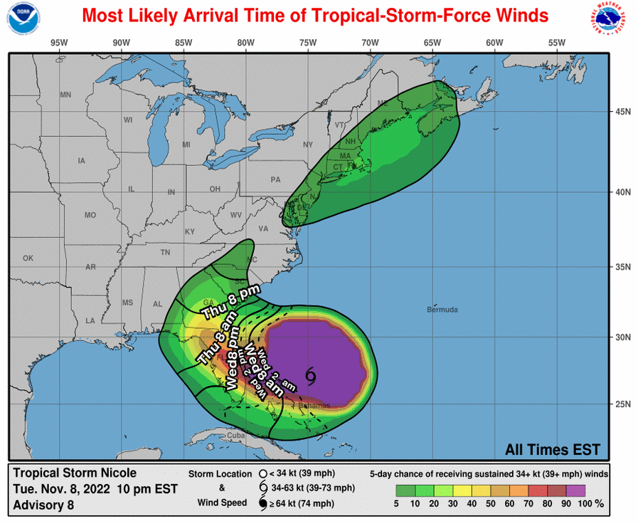
2. Hurricane conditions are expected across portions of the coast of southeast and east-central Florida beginning late Wednesday or Wednesday night, where a Hurricane Warning is in effect. Tropical storm conditions are expected in the Tropical Storm Warning areas in Florida and Georgia beginning early Wednesday.
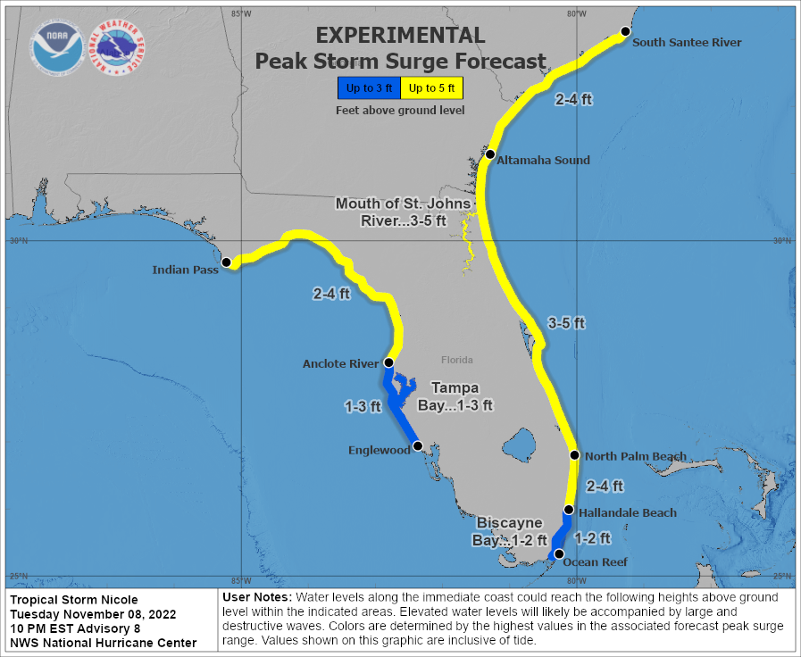
3. A dangerous storm surge is expected along much of the east coast of Florida and portions of coastal Georgia where a Storm Surge Warning is in effect. The storm surge will be accompanied by large and damaging waves. Residents in the warning area should listen to advice given by local officials.
4. Do not focus on the exact track of Nicole since it is expected to be a large storm with hazards extending well to the north of the center, outside of the forecast cone. These hazards are likely to affect much of the Florida peninsula and portions of the southeast United States.
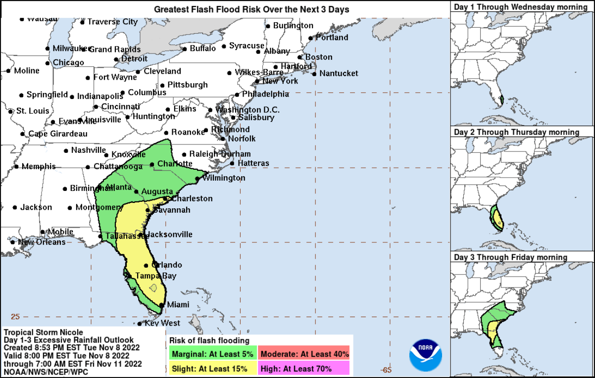
5. Nicole will produce heavy rainfall Wednesday and Thursday across the Florida Peninsula. Flash and urban flooding will be likely across portions of the Florida Peninsula along with possible renewed river rises on the St. Johns River. On Friday and Saturday, flash, urban and small stream flooding will be possible in the Southeast through the Mid-Atlantic and central Appalachians.
Category: ALL POSTS, Severe Weather, Tropical
About the Author (Author Profile)
Scott Martin is an operational meteorologist, professional graphic artist, musician, husband, and father. Not only is Scott a member of the National Weather Association, but he is also the Central Alabama Chapter of the NWA president. Scott is also the co-founder of Racecast Weather, which provides forecasts for many racing series across the USA. He also supplies forecasts for the BassMaster Elite Series events including the BassMaster Classic.Subscribe
If you enjoyed this article, subscribe to receive more just like it.


