

Nicole Now at Hurricane Strength; Dangerous Storm Surge & Strong Winds Hitting the Grand Bahama Island
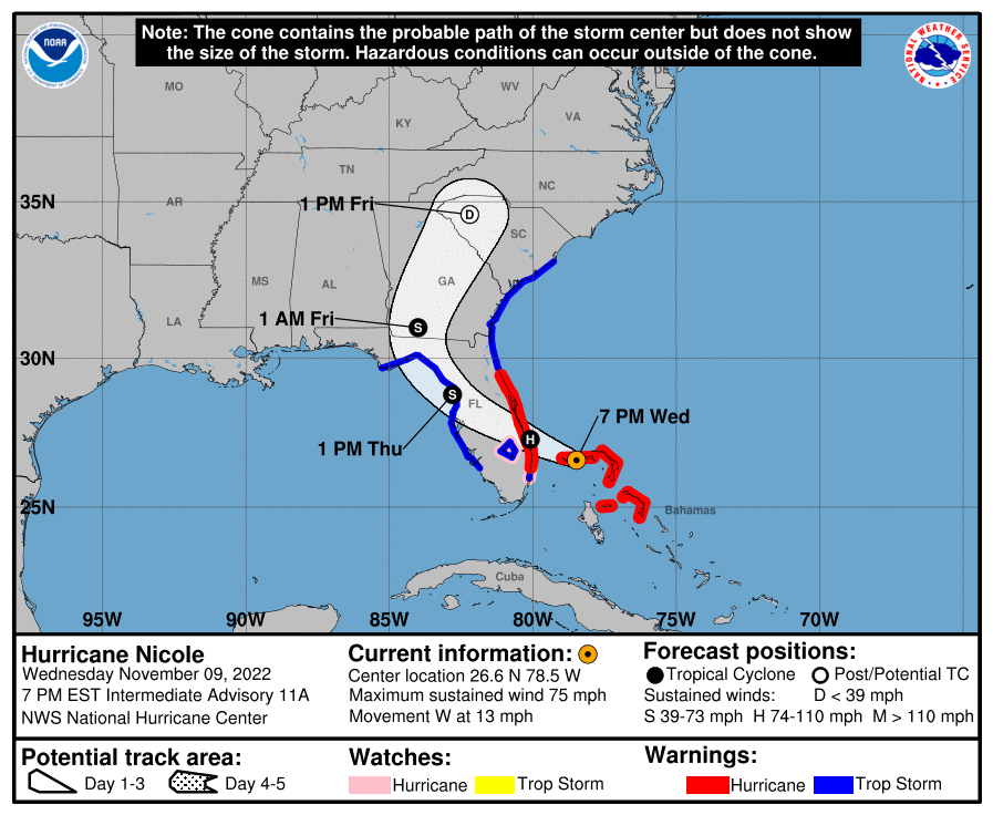
NICOLE CONTINUES BRINGING A DANGEROUS STORM SURGE AND STRONG WINDS TO GRAND BAHAMA ISLAND.
SUMMARY OF 700 PM EST…0000 UTC…INFORMATION
———————————————-
LOCATION…26.6N 78.5W
ABOUT 20 MI…30 KM ENE OF FREEPORT GRAND BAHAMA ISLAND
ABOUT 100 MI…160 KM E OF WEST PALM BEACH FLORIDA
MAXIMUM SUSTAINED WINDS…75 MPH…120 KM/H
PRESENT MOVEMENT…W OR 280 DEGREES AT 13 MPH…20 KM/H
MINIMUM CENTRAL PRESSURE…980 MB…28.94 INCHES
WATCHES AND WARNINGS
——————–
A Hurricane Warning is in effect for…
* The Abacos, Berry Islands, and Grand Bahama Island in the northwestern Bahamas
* Boca Raton to Flagler/Volusia County Line Florida
A Tropical Storm Warning is in effect for…
* Bimini in the northwestern Bahamas
* Hallandale Beach Florida to Boca Raton Florida
* Flagler/Volusia County Line Florida to South Santee River South Carolina
* North of Bonita Beach to Indian Pass Florida
* Lake Okeechobee
A Storm Surge Warning is in effect for…
* North Palm Beach Florida to Altamaha Sound Georgia
* Mouth of the St. Johns River to Georgetown Florida
* Anclote River Florida to Ochlockonee River Florida
A Hurricane Watch is in effect for…
* Hallandale Beach to Boca Raton Florida
* Lake Okeechobee
A Storm Surge Watch is in effect for…
* Ochlockonee River to Indian Pass Florida
* South of North Palm Beach to Hallandale Beach Florida
* Altamaha Sound Georgia to South Santee River South Carolina
DISCUSSION AND OUTLOOK
———————-
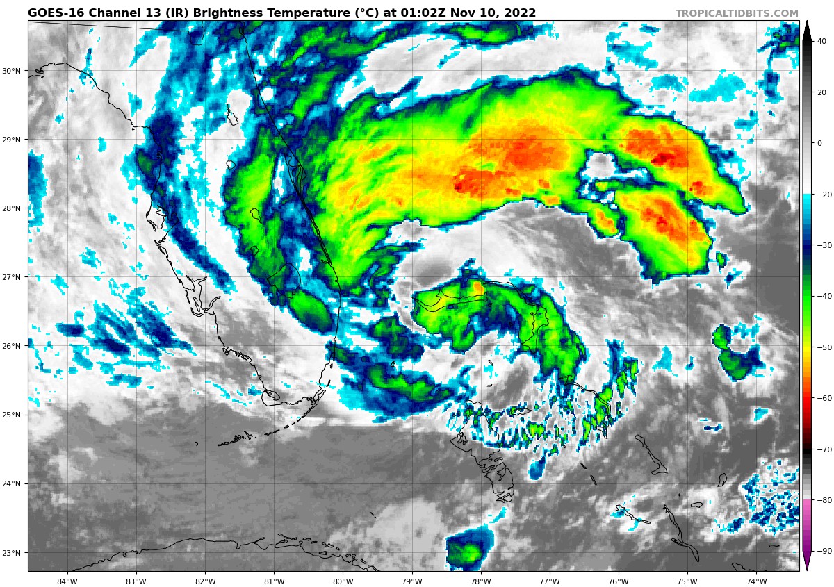
At 700 PM EST (0000 UTC), the center of Hurricane Nicole was located near latitude 26.6 North, longitude 78.5 West. Nicole is moving toward the west near 13 mph (20 km/h). A turn toward the west-northwest is expected tonight, followed by a turn toward the northwest on Thursday, and north or north-northeast on Friday. On the forecast track, the center of Nicole will move near or over Grand Bahama Island in the northwestern Bahamas this afternoon and evening, and move onshore the east coast of Florida within the hurricane warning area tonight. Nicole’s center is then expected to move across central and northern Florida into southern Georgia Thursday and Thursday night, and into the Carolinas Friday.
Maximum sustained winds are near 75 mph (120 km/h) with higher gusts. Little change in strength is expected this evening, and Nicole is forecast to remain a hurricane until it reaches the east coast of Florida tonight or early Thursday. Nicole is expected to weaken while moving across Florida and the southeastern United States Thursday through Friday, and it is likely to become a post-tropical cyclone by Friday afternoon.
Hurricane-force winds extend outward 10 miles (20 km) from the center and tropical-storm-force winds extend outward up to 485 miles (780 km) from the center especially to the north of the center. A Mesonet observation site on Freeport, Grand Bahama Island recently reported a wind gust to 61 mph (98 km/h).
The estimated minimum central pressure is 980 mb (28.94 inches).
HAZARDS AFFECTING LAND
———————-
WIND: Hurricane and tropical storm conditions will continue across portions of the northwestern Bahamas through tonight. Tropical storm conditions will continue along portions of the east coast of Florida, Georgia, and South Carolina in the warning areas into Thursday. Hurricane conditions are expected within the hurricane warning area in Florida tonight or Thursday morning. Hurricane conditions are possible within the hurricane watch area tonight. Tropical storm conditions are expected within the warning area along the west coast of Florida by this evening or tonight.
STORM SURGE: The combination of a dangerous storm surge and the tide will cause normally dry areas near the coast to be flooded by rising waters moving inland from the shoreline. The water could reach the following heights above ground somewhere in the indicated areas if the peak surge occurs at the time of high tide…
* North Palm Beach Florida to Altamaha Sound Georgia including the St. Johns River to the Fuller Warren Bridge…3 to 5 ft
* Anclote River to Ochlockonee River…3 to 5 ft
* Altamaha Sound Georgia to the South Santee River South Carolina…2 to 4 ft
* St. Johns River south of the Fuller Warren Bridge to Georgetown Florida…2 to 4 ft
* Hallandale Beach to North Palm Beach…2 to 4 ft
* Ochlockonee River to Indian Pass…2 to 4 ft
* Englewood to Anclote River including Tampa Bay…1 to 3 ft
* North of Ocean Reef to Hallandale Beach including Biscayne Bay…1 to 2 ft
* South Santee River to Surf City North Carolina…1 to 2 ft
Storm surge could raise water levels by as much as 4 to 6 feet above normal tide levels along the immediate coast of the northwestern Bahamas in areas of onshore winds.
The deepest water will occur along the immediate coast near and to the north of the landfall location, where the surge will be accompanied by large and destructive waves. Surge-related flooding depends on the relative timing of the surge and the tidal cycle, and can vary greatly over short distances.
RAINFALL: Nicole is expected to produce the following rainfall amounts through Saturday:
Northwest Bahamas into the eastern, central and northern portions of the Florida Peninsula: 3 to 5 inches with local maxima of 8 inches.
Southeast into the southern and central Appalachians, western Mid-Atlantic, and eastern portions of Tennessee, Kentucky, and Ohio: 2 to 4 inches with local maxima of 6 inches along the Blue Ridge.
Northern Mid-Atlantic into New England: 1 to 4 inches.
Flash and urban flooding will be possible, along with renewed river rises on the St. Johns River, across the Florida Peninsula today into Thursday. Heavy rainfall from this system will spread northward across portions of the Southeast, eastern Ohio Valley, Mid-Atlantic, and New England Thursday into Friday night, where limited flooding impacts will be possible.
TORNADOES: A few tornadoes are possible tonight across eastern Florida, and Thursday from northeastern Florida into parts of southeast Georgia, eastern South Carolina, and southeast North Carolina.
SURF: Large swells generated by Nicole will affect the northwestern Bahamas, the east coast of Florida, and much of the southeastern United States coast during the next few days. These swells are likely to cause life-threatening surf and rip current conditions.
Category: ALL POSTS, Severe Weather, Tropical
About the Author (Author Profile)
Scott Martin is an operational meteorologist, professional graphic artist, musician, husband, and father. Not only is Scott a member of the National Weather Association, but he is also the Central Alabama Chapter of the NWA president. Scott is also the co-founder of Racecast Weather, which provides forecasts for many racing series across the USA. He also supplies forecasts for the BassMaster Elite Series events including the BassMaster Classic.Subscribe
If you enjoyed this article, subscribe to receive more just like it.


