


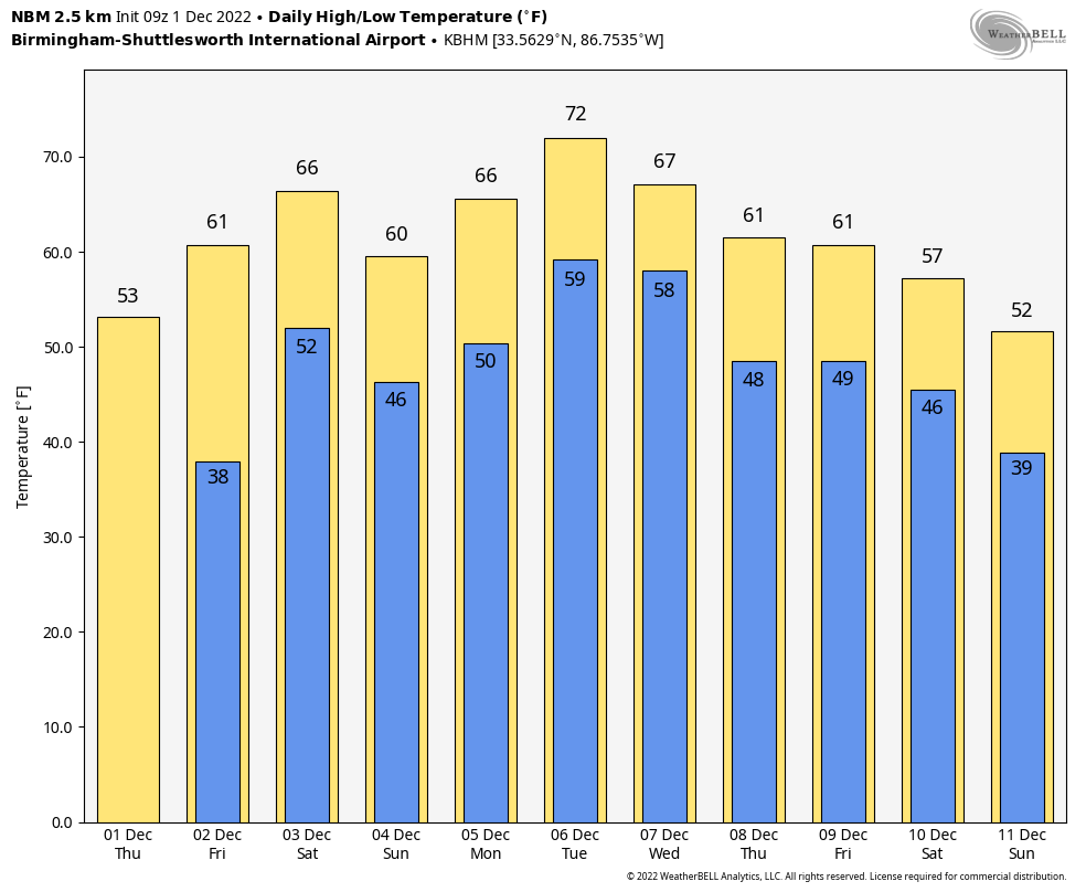
COLD START: Temperatures are in the 28-32 degree range over much of North Alabama early this morning… we see upper 30s down to the Gulf Coast. Today will be sunny with a high in the 50s over North Alabama… temperatures reach the 60s over the southern counties. Dry weather continues tomorrow with a partly sunny sky.
THE ALABAMA WEEKEND: A surface front will drift into the state and become stationary, meaning the weekend will be mostly cloudy with some rain at times. Not a washout at all, and there is no risk of severe storms. Probably little thunder. But, there will be some rain from time to time Saturday and Sunday with highs in the 60s. Rain amounts over the weekend will average 1/2 inch, with potential for heavier totals over the northern quarter of the state.
NEXT WEEK: Unsettled weather will continue Monday through Wednesday with some risk of showers on a daily basis; the weather will be mild with highs in the 60s and 70s. Cooler, drier air will filter into the state on Thursday and Friday, but still no sign of any bitterly cold Arctic air around here for the next 7-10 days. On the positive side, we are seeing no sign of severe storms through the next 10 days. See the daily Weather Briefing video for maps, graphics, and more details.
STORM SURVEYS: NWS survey teams from Birmingham and Mobile have confirmed 5 tornadoes from the Tuesday night event across Alabama. The strongest is an EF-3 that moved through Washington County in Southwest Alabama; it originated in Greene County, MS and was on the ground for 19 miles. It proceed damage at Fruitdale and Tibbie. An EF-2 moved through the Flatwood community just north of Montgomery, where three people were killed.
Survey work will continue for the next few days; areas of interest include: Barbour, Blount, Calhoun, Dallas, Lamar, Marengo, and Pike counties.
ON THIS DATE IN 1970: Four tornadoes impacted east-central Wisconsin during the morning hours. The strongest tornado, an F3, formed at 10:15 AM near Medina in Outagamie County. The twister moved northeast at 50 mph and destroyed twenty barns and five houses.
ON THIS DATE IN 2006: A winter storm produced more than 6 inches of snow along a 1,000-mile-long path from central Oklahoma to northern Michigan from November
BEACH FORECAST: Click here to see the AlabamaWx Beach Forecast Center page.
Look for the next Weather Briefing video here by 3:00 this afternoon… enjoy the day!


