

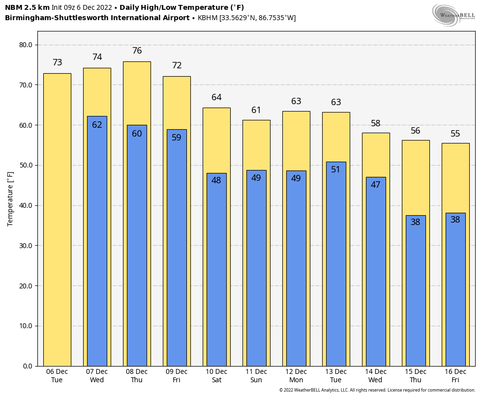
Temperatures Near Record Levels Through Friday; A Few Showers Today
RADAR CHECK: We have a few scattered showers over the northern half of Alabama this morning; nothing especially heavy or widespread. We will mention the chance of showers over North/Central Alabama today and early tonight… then just a small risk of a shower tomorrow and Thursday as an upper ridge builds over the region. South Alabama will remain generally dry through mid-week.
The big story is the December warmth. Temperatures are in the mid to upper 60s over much of the state early this morning at sunrise, which is almost ten degrees above the average high for December 6 (59). The exception is the northeast corner of the state, where cold air damming (CAD) is keeping temperatures in the upper 40s and low 50s. The mild air reaches that part of the state later this morning.
Highs will be in the 70s through Friday, not far from record levels.
Here are the record highs for Birmingham… not expecting to break them, but it will be close.
December 6 (today) 78, set in 1998
December 7 (tomorrow) 80, set in 1951
December 8 (Thursday) 79, set in 1978
December 9 (Friday) 74, set in 1946
FRIDAY AND THE WEEKEND: A cold front will bring the risk of showers Friday, but thankfully no risk of severe storms despite the warm, humid conditions. Then, for the weekend for now Saturday looks relatively dry with only an outside risk of a shower along with a mix of sun and clouds. Then, periods of rain look likely Sunday as moist air surges northward. Highs over the weekend will be in the 60s.
NEXT WEEK: While a few scattered showers are possible Monday and Tuesday, the rain will be more widespread Wednesday, along with the chance of a few thunderstorms. Cooler, drier air returns Thursday and Friday. Highs will be in the 60s for the first half of the week, then dropping into the 50s by Thursday. We do note global models are showing signals for colder weather for the Deep South over the latter half of December… See the daily Weather Briefing video for maps, graphics, and more details.
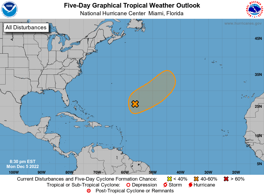
TROPICS: A large and complex area of low pressure located over the central subtropical Atlantic about 800 miles northeast of the northern Leeward Islands continues to produce a broad area of disorganized showers and thunderstorms. Environmental conditions appear conducive for this system to acquire some subtropical or tropical characteristics while it meanders generally northeastward during the next few days. By Friday, the low is expected to move over cooler waters and interact with a mid-latitude trough, limiting potential of tropical transition after that time. This system is far from land and won’t impact the U.S.
ON THIS DATE IN 1913: A snowstorm from December 1st through the 6th dumps a record total of 45.7 inches in Denver, Colorado. This storm produced the most snow ever recorded in a single Denver snowstorm.
ON THIS DATE IN 1983: An F3 tornado moved through Selma during the pre-dawn hours; it on the ground for 13 miles. At least 103 structures were damaged/destroyed along the path. 30-40 vehicles at a new car dealership were destroyed. Numerous units at The Rangedale Housing Project in Selma were demolished. There was one fatality here. Clarence Chappell was asleep when the tornado hit. A dormitory at Selma University was struck by the twister. 50 students were occupying the dorm at the time. Seven students received minor injuries when the roof and parts of the second floor of their dorm was destroyed.
BEACH FORECAST: Click here to see the AlabamaWx Beach Forecast Center page.
Look for the next Weather Briefing video here by 3:00 this afternoon… enjoy the day!
Category: Alabama's Weather, ALL POSTS, Weather Xtreme Videos
About the Author (Author Profile)
James Spann is one of the most recognized and trusted television meteorologists in the industry. He holds the AMS CCM designation and television seals from the AMS and NWA. He is a past winner of the Broadcast Meteorologist of the Year from both professional organizations.Subscribe
If you enjoyed this article, subscribe to receive more just like it.


