

Sunday Afternoon Forecast Update: GFS Introducing Idea of Some Wintry Precipitation Next Sunday for Alabama
Today’s forecast is in pretty good shape except for the high. This is not a one number region as we always say, but if we are figuring the average high for Tuscaloosa, Birmingham, and Anniston. Temperatures have been a little cooler than I expected. 63F at Tuscaloosa, but Birmingham has struggled to get above 61F. Anniston is in the 50s with the rain.
I had put in a rumble of thunder but can take that out since we are seeing nothing on the Global Lightning Mapper data. There could be some over South Alabama.
Big question for Monday is cloud cover and rain chances. Latest data shows mostly cloudy skies, with only a few breaks in the overcast. 63-64 looks pretty much the average for high. I will go with 64. Brought back chances for rain tomorrow night with the warm front retreating northward. Could see a couple of wind gusts to 15 mph so I added that without mention in the text.
Tuesday will be the big severe weather day to the west of Alabama. Conditions look favorable for tornadoes in the Enhanced Risk area from the SPC including Shreveport, Monroe, and Alexandria LA. CAPES near 2,000, 200 m2/s2 of low level helicty, and STP values around 2 spell trouble. For us, a shower in the morning, mostly cloudy and breezy. Showers and storms don’t reach West Alabama until near sunrise. The easterly wedge keeps us cool from I-65 eastward with 60F for the high, West Alabama will be warmer, in the lower and middle 60s.
Wednesday: The forecast looks good with widespread rain and storms during the day. Looks like instability peaks south of Tuscaloosa during the mid-afternoon period. A very slim risk of a tornado. Will be something to watch, but think the biggest risk will be over far southwestern Alabama. Will introduce a marginal threat just in case. Will have to watch out for a heavy rain threat.
Here is WPC rainfall graphic through early Sunday morning:
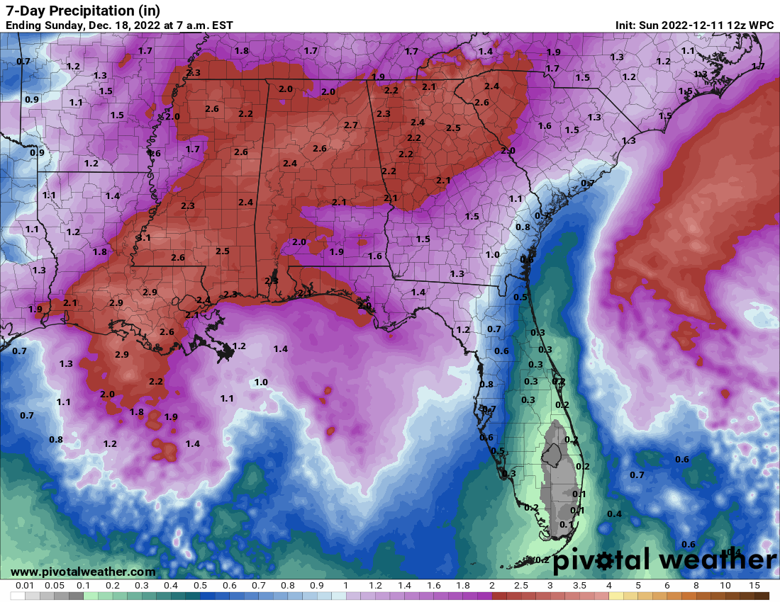
most of that falls Wednesday.
Thursday: Pretty quick clearing behind the front. Raised temps a bit.
Friday: Raised morning low to slightly above freezing. Some areas will hit freezing though. Northern half afternoon highs stay in the 40s.
Saturday forecast looks good, sunny and cool. Highs in 40s still for most.
Introducing Sunday: Morning run of the GFS says show for the northern half of Alabama. Hmmmmm….Euro says GFS is smoking crack and predicts a cold rain for South Alabama. Well that will be interesting to watch. The GFS 06z run was onto wintry precip and so was the 0z. Things that make you go hmmm…. We will be watching.
Category: Alabama's Weather, ALL POSTS, Severe Weather, Winter Weather
About the Author (Author Profile)
Bill Murray is the President of The Weather Factory. He is the site's official weather historian and a weekend forecaster. He also anchors the site's severe weather coverage. Bill Murray is the proud holder of National Weather Association Digital Seal #0001 @wxhistorianSubscribe
If you enjoyed this article, subscribe to receive more just like it.


