

Midday Nowcast: Severe Clear Across Alabama Today
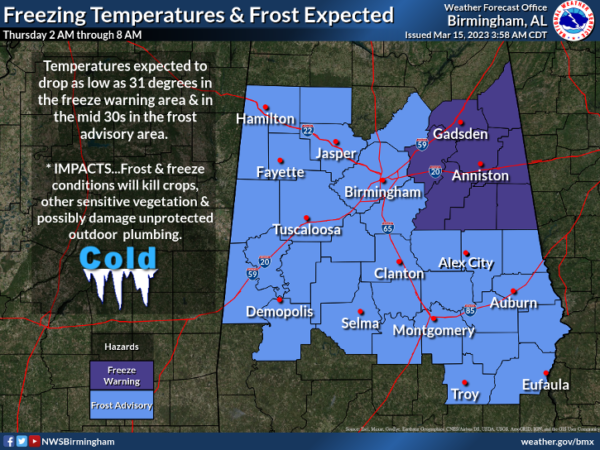
Sunshine in full supply and slightly warmer temperatures for the rest of our Wednesday with highs in the lower 60s for many locations. Tonight will be another clear and cold one with lows in the low to upper 30s, and we do have another freeze warning in effect for East Alabama, while the rest of the area is included in a frost advisory.
Tomorrow will be the warmest day of the week as highs surge into the upper 60s and lower 70s as a strong southerly wind takes over. We will see more sun than clouds tomorrow, but tomorrow night clouds return.
ACROSS THE USA: The atmospheric river will continue to impact California into Wednesday. This potent storm is expected to produce heavy mountain snow and gusty winds from the Sierra to the central/northern Rockies. As the cold front moves into the Southwest, locally heavy rain could lead to isolated flooding over parts of central Arizona. A storm in the Gulf of Alaska will bring a wintry mix to southeast Alaska.
WET & STORMY FRIDAY: Little change for Friday as we are forecasting a soggy St. Patrick’s Day for Alabama. A cold front will bring rain and storms to the state.
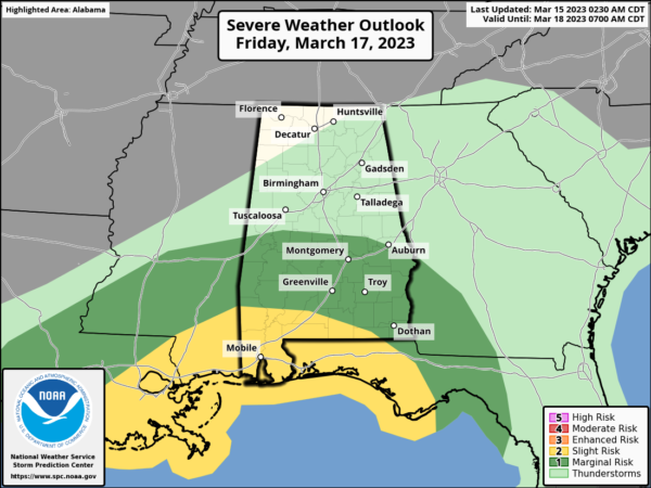
The SPC has introduced a “slight risk” (level 2/5) of severe thunderstorms for the southwest corner of the state, including places like Mobile, Gulf Shores, Jackson, and Atmore. A “marginal risk” (level 1/5) extends as far north as Greensboro and Auburn. The main threat will come from strong, gusty winds…an isolated tornado can’t ruled out, especially down near the Gulf Coast, where some surface based instability will be available.
For most of the state, it will be a cool, rainy day in a stable airmass. Rain amounts Friday will average around one inch, with isolated heavier totals. Temperatures will range from the upper 50s to mid 60s across North/Central Alabama Friday.
COLDER WEEKEND: Another shot of cold air rolls into the Deep South over the weekend as the front moves through the region. Temperatures will be in the low to mid 30s early Saturday with a brisk north wind. The sky will become sunny Saturday with a high in the 50s. Clear weather is the story Sunday with another late season freeze during the early morning hours…lows will dip into the 24-34 degree range. The high Sunday will be in the 50s.
NEXT WEEK: Another freeze is likely for North/Central Alabama early Monday, but the day will be mainly sunny with highs closer to 60°. On Tuesday, a low forms in the northeast Gulf of Mexico, spreading rain northward across the state It will be a cold rain with temperatures only in the 40s and 50s. Rain will end Wednesday morning as the low moves northeast. Thursday looks dry at this point, followed by a chance of showers Friday. Temperatures will likely reach the 70s by the end of the week.
BEACH FORECAST CENTER: Get the latest weather and rip current forecasts for the beaches from Fort Morgan to Panama City on our Beach Forecast Center page. There, you can select the forecast of the region that you are interested in visiting.
WORLD TEMPERATURE EXTREMES: Over the last 24 hours, the highest observation outside the U.S. was 115.5F at Matam, Senegal. The lowest observation was -75.1F at Concordia, Antarctica.
CONTIGUOUS TEMPERATURE EXTREMES: Over the last 24 hours, the highest observation was 87F at Ochopee, FL. The lowest observation was -3F at Grayling, MI.
Category: Alabama's Weather, ALL POSTS
About the Author (Author Profile)
Macon, Georgia Television Chief Meteorologist, Birmingham native, and long time Contributor on AlabamaWX. Stormchaser. I did not choose Weather, it chose Me. College Football Fanatic. @Ryan_StinnetSubscribe
If you enjoyed this article, subscribe to receive more just like it.


