

Mesoscale Discussion 361 — New Tornado Watch Coming Soon
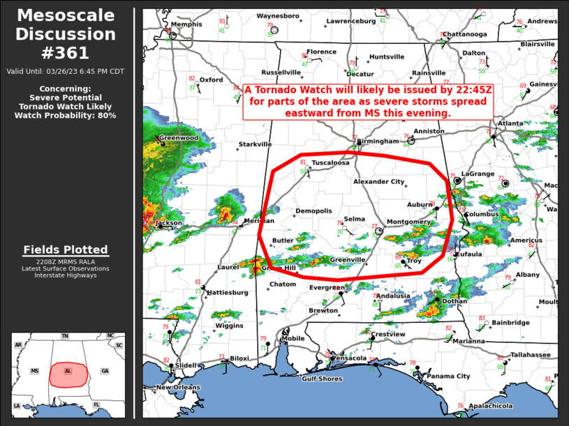
A Tornado Watch is likely to replace the Severe T-Storm Watch when it expires at 6 pm. This new watch will most likely be for all the southern half of Central Alabama to as far north as the I-20 corridor.
SUMMARY… A tornado watch will likely be issued by 2245Z for parts of central AL, as an additional round of severe storms spread eastward from MS this evening.
DISCUSSION… An east/west-oriented, outflow-modified moisture gradient extends across parts of central AL (near/just south of Birmingham). While a few strong to severe storms are ongoing south of this boundary (in Severe Thunderstorm Watch 86), an additional round of severe thunderstorms is expected to evolve out of eastern MS and perhaps southern AL in the next few hours. This activity will be aided by a developing/strengthening low-level jet (and related warm advection) over the central Gulf Coast later this evening. The strengthening southerly low-level jet beneath enhanced west-southwesterly flow aloft will favor discrete or semi-discrete supercell development, given the weak large-scale ascent. With increasing low-level streamwise vorticity and surface-based inflow for these discrete/semi-discrete supercells, the tornado threat (along with hail and damaging winds) will gradually increase. Therefore, a tornado watch will likely be issued by 2245Z.
Category: Alabama's Weather, ALL POSTS, Severe Weather
About the Author (Author Profile)
Scott Martin is an operational meteorologist, professional graphic artist, musician, husband, and father. Not only is Scott a member of the National Weather Association, but he is also the Central Alabama Chapter of the NWA president. Scott is also the co-founder of Racecast Weather, which provides forecasts for many racing series across the USA. He also supplies forecasts for the BassMaster Elite Series events including the BassMaster Classic.Subscribe
If you enjoyed this article, subscribe to receive more just like it.


