

Midday Nowcast: Muggy May Weather
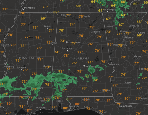
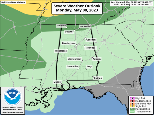
The weather this week will become more summer-like as it will be very warm, humid, and there will be scattered showers on the radar each day. For the rest of today, expect afternoon highs in the mid 80s for most locations and we are seeing a mix of sun and clouds, some additional showers or storms are possible this afternoon, but they should be widely spaced. An organized cluster of storms over Tennessee may clip North Alabama tonight and the SPC has the Tennessee Valley in a “marginal risk” (level 1/5) of severe thunderstorms tonight for the potential for hail and strong, gusty winds.
An upper ridge building in over the region means the weather will not be changing much the next seven days. Daily showers and storms are expected mainly during the afternoon and evening hours. Highs will be in the mid to upper 80s, and some spots are likely to reach 90 degrees for the first time this year. Temperatures this week will be 5-8 degree above average for this time of year.
ACROSS THE USA: Springtime weather across the country with the threat of severe thunderstorms and heavy rainfall from the Ohio and mid-Mississippi River Valley’s today. Elevated fire weather concerns may linger across portions of the Southwest. Meanwhile, another storm system approaching Northern California and Pacific Northwest will track across the Great Basin with rain and higher elevation snow.
WEEKEND WEATHER: More of the same with very warm weather; highs in the mid to upper 80s both Saturday and Sunday. The sky will be partly too mostly sunny with only widely scattered afternoon and evening showers and storms. Rolling into next week, not much change in the overall pattern, highs in the mid to upper 80s, a mix of sun ad clouds each day, and widely scattered afternoon showers.
BEACH FORECAST CENTER: Get the latest weather and rip current forecasts for the beaches from Fort Morgan to Panama City on our Beach Forecast Center page. There, you can select the forecast of the region that you are interested in visiting.
WORLD TEMPERATURE EXTREMES: Over the last 24 hours, the highest observation outside the U.S. was 117.7F at Matam, Senegal. The lowest observation was -94.2F Amundsen-Scott South Pole Station, Antarctica.
CONTIGUOUS TEMPERATURE EXTREMES: Over the last 24 hours, the highest observation was 105F at Rio Grande Village, TX. The lowest observation was 18F at Walker, CA.
Category: Alabama's Weather, ALL POSTS
About the Author (Author Profile)
Macon, Georgia Television Chief Meteorologist, Birmingham native, and long time Contributor on AlabamaWX. Stormchaser. I did not choose Weather, it chose Me. College Football Fanatic. @Ryan_StinnetSubscribe
If you enjoyed this article, subscribe to receive more just like it.


