

Scattered Storms Fire Up Again This Afternoon
ANOTHER HOT, HUMID DAY DAY: Expect a high in the 88-92 degree range across most of Alabama this afternoon with a mix of sun and clouds. Random, scattered showers and storms will fire up again during the heat of the day, mostly between 2:00 and 9:00 p.m. Chance of any one location seeing rain today is 50-60 percent, and like yesterday some of the storms will produce heavy rain, small hail, and gusty winds.
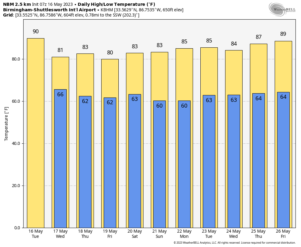
Heat levels will come down tomorrow through Friday with highs closer to 80 degrees over the northern half of the state, and we will need to maintain the daily chance of showers and storms, mostly during the afternoon and evening hours. It won’t rain all day, and it won’t rain everywhere. The chance of any one spot getting wet each day will remain in the 50-60 percent range.
THE ALABAMA WEEKEND: A surface front will move through the state Saturday, so the risk of a passing shower or storm will stay in the forecast. Otherwise, the sky will be occasionally cloudy with a high close to 80. Then, a drier airmass will drop into the state Sunday with lower humidity and a mostly sunny sky.
NEXT WEEK: Model guidance is now suggesting moist air will try and return Monday, and we will insert the chance of widely scattered showers. The rest of the week looks fairly quiet with a few isolated showers around daily along with highs in the 80s. No sign of any organized severe weather threat, and it sure looks like we can pretty much stick a fork in the tornado season. See the video briefing for maps, graphics, and more details.
HOTTEST SO FAR: Birmingham’s high yesterday was 93 degrees, making it the hottest day so far this year. We also note it was just one degree away from the record high for May 15, 94 set in 1899. Here is a list of some highs across the state yesterday…
Troy 96
Mobile 95
Dothan 94
Birmingham 93
Huntsville 93
Tuscaloosa 93
Montgomery 93
Demopolis 93
Muscle Shoals 90
Gadsden 89
Anniston 88
ON THIS DATE IN 1983: An unyielding spring storm dumped heavy snow across the Front Range in Colorado. High winds of 20 to 40 mph with gusts to 55 mph produced blizzard conditions at times. The Foothills received 1 to 2 feet of snow with 4 to 12 inches along the Foothills.
ON THIS DATE IN 1989: Thunderstorms developing ahead of a cold front produced severe weather in the south-central U.S. Thunderstorms spawned twenty tornadoes, and there were 180 reports of large hail and damaging winds. A tornado in Cleburne, Texas caused thirty million dollars damage. A violent F-4 tornado touched down near Brackettville, Texas and a strong F-3 tornado killed one person and injured 28 others at Jarrell, Texas.
Look for the next video update here by 3:00 this afternoon… enjoy the day!
Category: Alabama's Weather, ALL POSTS, Weather Xtreme Videos
About the Author (Author Profile)
James Spann is one of the most recognized and trusted television meteorologists in the industry. He holds the AMS CCM designation and television seals from the AMS and NWA. He is a past winner of the Broadcast Meteorologist of the Year from both professional organizations.Subscribe
If you enjoyed this article, subscribe to receive more just like it.


