


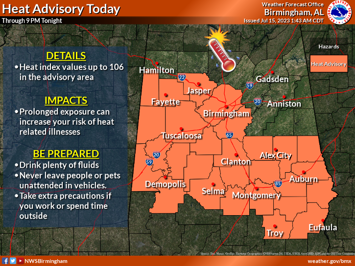
A boundary from a weakening MCS will be moving into the northern parts of the area this morning and will slowly move southward across North and Central Alabama through the day and into the evening. Showers and storms will be possible this morning over the northern half of the area, and will become likely by afternoon for the whole area. A few storms may be strong with gusty winds. Unfortunately, with the dewpoints approaching 80 degrees, the heat index will be in Heat Advisory range for a good portion of Central Alabama. Highs in the upper 80s to the mid 90s.
Slightly drier air will move into the area on Sunday, and rain chances will be lower. We’ll have a chance of a few isolated to scattered showers and storms by the afternoon hours. Highs in the lower to mid 90s.
We’ll hang on to a chance of a few isolated to scattered showers and storms on Monday as the weather doesn’t change that much for the start of the work week. Highs in the lower to mid 90s.
Ridging moves in to take over our weather pattern on Tuesday, and we’ll start to see an increase in daytime highs. Nearly everyone will be dry, but a stray shower or two will be possible. Highs in the mid to upper 90s for most.
Same story on Wednesday, as it will be hot with a very small chance of an isolated shower. Highs in the mid to upper 90s.
Thursday will be nearly identical as well, with hot temperatures and only a miniscule chance of a stray shower. Highs in the mid to upper 90s.
And at the end of the forecast period on Friday… The ridge begins to weaken a little, and we look to have a weak front move into the area. We’ll have a chance of scattered afternoon showers and storms with highs in the 90s.
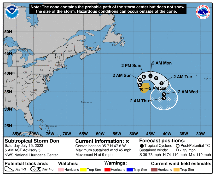
Subtropical Storm Don continues to wonder around over the open waters of the Atlantic Ocean, with winds at 45 mph. His projected path will look like a horseshoe over the next few days and will eventually stall out as the steering currents look to collapse by midweek. Don should remain around the same intensity during this time.


