Low clouds and fog have ben slow to burn off this morning over western portions of the Tennessee Valley. Also over eastern sections of the state near the Georgia border. But those clouds and fog are just about gone as we approach the noon hour.
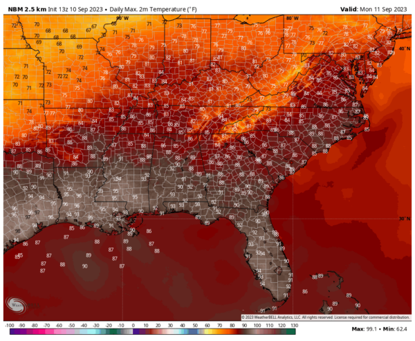
Temperatures are in the upper 70s north and near 80F over southern sections. Morning readings started off at 62F at Anniston, Tuscaloosa at 64F and 66F at Birmingham and Calera. For the second straight morning, Eufaula was Central Alabama’s cool spot, reporting in at 60F once again.
Afternoon highs will be in the middle 80s North, upper 80s North Central, and near 90F South Central.
A weak surface low is located near Eufaula this afternoon, with a warm front trailing to the south. A weak surface trough continues from eastern and northeastern Alabama into Middle Tennessee.
Regional radars are quiet and only a few isolated showers or storms are expected over the eastern half of Alabama today. Peak time for them would be around 4-6 p.m. but they won’t amount to much.
There could be an isolated shower overnight, but again, nothing of any significance. Lows will be in the 60s.
Monday will feature partly cloudy skies and widely scattered showers and thunder mainly east of I-65. Monday highs will look a lot like those of today.
A deep upper level trough will be moving into the Great Lakes states Monday night and Tuesday and this will push a cold front south towards the Tennessee Valley. A few showers may show up over northwestern sections of Alabama by early Tuesday morning. There could be a few showers and storms over the northern third of the state Tuesday, but the front is mostly moisture starved, so don’t expect much in teh way of rain.
The main effect of the trough will be to deliver drier air for Thursday and Friday.
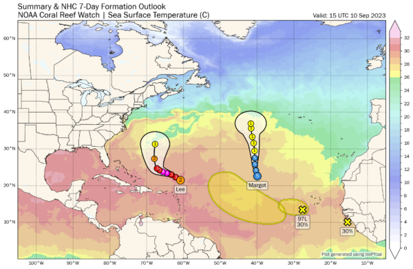
Its other job will be to steer Hurricane Lee east of New England. The 12z run of the GF does brush Cape Cod and Nantucket, and the 12z European had a direct landfall in Rhode Island Sunday night. So interests in New England needs to still be making preliminary preparations just in case it does take a track closer to their coastline. The provinces in Atlantic Canada also need to be preparing. The GFS a category one hurricane tracking along the coast of Nova Scotia during the day Sunday. The Euro projected landfall Sunday in Nova Scotia as well with a cat 1 also.
Lee will bring tropical storm force gusts to Bermuda early Friday morning. They should not exceed 45 mph.
Right now Lee has top winds of 110 mph and is located about 270 miles north of the northenmost Leeward Islands like the USVI and Anguilla and St. Martin.
Margot is steady state about 1,200 miles west northwest of the Cape Verde Islands in the middle of the Atlantic, no threat to any land areas for the foreseeable future. Top winds are 50 mph and it is expected to become a hurricane by Tuesday.
The next storm up is Nigel. The NHC is tracking two systems, one near the Cape Verde Islands, and another about to come off Africa that have shots at becoming Nigel. Or maybe Nigel and Ophelia. The GFS has the first system becoming Nigel by midweek and carries it a couple of hundred miles north of Puerto Rico by next weekend, menacing the Mid-Atlantic and New England as it brushes the Outer Banks of North Carolina before turning it to the east and taking it out to sea.


