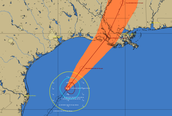
Hurricane Francine was upgraded to a hurricane at 7 pm tonight after both NOAA and Air Force Hurricane Hunter missions collected data indicating 700 mb flight-level winds of 76 knots, supporting surface winds of 65 knots (75 mph). The minimum central pressure has dropped to 980 mb, signaling strengthening, with deep convection developing around the center. While Francine has formed a well-organized inner core, some dry air remains outside the core region.
There are bursts of convection, but there is shear evident on the storms western side. The Air Force Hurricane Hunters are on an inbound pass into the center and we will have some more information shortly. But the wind field is definitely stronger and more organized than it was earlier today.
SUMMARY OF 1000 PM CDT…0300 UTC…INFORMATION
———————————————–
LOCATION…26.4N 94.3W
ABOUT 185 MI…295 KM ENE OF MOUTH OF THE RIO GRANDE
ABOUT 295 MI…475 KM SW OF MORGAN CITY LOUISIANA
MAXIMUM SUSTAINED WINDS…75 MPH…120 KM/H
PRESENT MOVEMENT…NE OR 35 DEGREES AT 10 MPH…17 KM/H
MINIMUM CENTRAL PRESSURE…980 MB…28.94 INCHES
Francine is now moving faster to the northeast at 9 knots, influenced by an approaching mid- to upper-level trough over Texas. It is expected to accelerate toward the Louisiana coast, with landfall anticipated late Wednesday afternoon or evening. After landfall, Francine will turn north-northeast and slow down as it moves over eastern Louisiana and Mississippi. The forecast track is consistent with model predictions, showing good agreement.
As the system remains over warm waters and in a low wind shear environment, significant strengthening is expected overnight into Wednesday morning. Francine could approach Category 2 strength before encountering increased wind shear and dry air just before landfall, which would halt further intensification. Rapid weakening is expected once it moves inland.
A life-threatening storm surge will impact parts of the Louisiana and Mississippi coastlines, where storm surge warnings are in effect. Hurricane-force winds are expected in southern Louisiana on Wednesday, where a Hurricane Warning is also in effect. Heavy rainfall is forecast across eastern Louisiana, Mississippi, southern Alabama, and the western Florida Panhandle, with flash flooding likely in these areas, extending into the Lower Mississippi and Tennessee Valleys by Wednesday night into Friday morning.


