


THE FINAL DAYS OF APRIL: More sun than clouds through midweek with only isolated showers and storms, mainly during the afternoon and evening hours. Highs will be in the mid-80s which are several degrees above average for the end of April.
BIRMINGHAM ALMANAC: For April 28th, the average high for Birmingham is 78° and the average low is 56°. The record high is 89° set in 1899, while the record low is 37° set in 1973. We average 0.16” of precipitation on this date and the record value is 1.60” set in 1984.
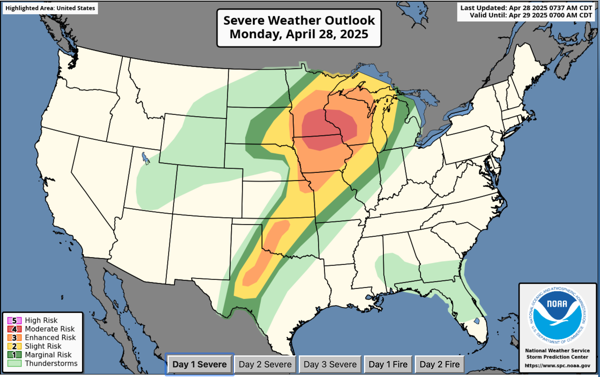
USA BRIEF: Multiple corridors of severe thunderstorms are expected across the Upper Midwest today and tonight, with a severe weather outbreak including strong tornado potential possible. The most dangerous period is likely during the late afternoon and evening when strong tornado potential should be maximized. Large to very large hail and strong, damaging winds are likely as well.
HELLO MAY: A cold front will move towards Alabama on Thursday and the chance of showers and thunderstorms will increase. Showers and storms should become widespread Thursday nigh into Friday as the front moves through the state. For now, we are not expecting severe storms as the main dynamics will be well to the north of Alabama. Rain amounts will be in the 1/2 to 1 inch range and will be a welcome sight for many locations across Alabama.
WONDERFUL WEEKEND WEATHER: Cooler, drier air will roll into the state late Friday night, setting up a beautiful Saturday. Highs drop into the 70s over the northern half of the state with lower humidity, and temperatures drop into the 50s over much of Alabama early Sunday morning. A few colder spots over the northern half of the state could reach the upper 40s. Sunday looks mostly dry and pleasant with a high not far from 80 degrees.
NEXT WEEK: Moisture level begin to rise early next week, and we will bring the chance of showers back to Alabama. These will be daily isolated in nature, and will occur mainly during the afternoon and evening hours. Highs will be in the 80s, lows will be in the 60s.
WORLD TEMPERATURE EXTREMES: Over the last 24 hours, the highest observation outside the U.S. was 117.7F at King Fahad International Airport, Dammam, Saudi Arabia. The lowest observation was -78.7F at Dome C, Antarctica.
CONTIGUOUS TEMPERATURE EXTREMES: Over the last 24 hours, the highest observation was 109F at Rio Grande Village, TX. The lowest observation was 11F at Peter Sinks, UT.


