Wet Today; Snow Late Tonight and Early Tomorrow
An all new edition of the ABC 33/40 Weather Xtreme video is available in the player on the right sidebar of the blog. You can subscribe to the Weather Xtreme video on iTunes by clicking here.
TODAY: Widespread light rain will continue with temperatures holding mostly in the low to mid 40s, thanks to our deepening surface low just off the Louisiana coast. Amounts over this part of Alabama will be generally under 1/2 inch, with some heavier totals over South Alabama. But, down there, convection over the Gulf might keep amounts under one inch. No snow or ice issues through midnight tonight.
TONIGHT/TOMORROW: The surface low moves northeast to the Atlantic coast, and a deep upper low moves over North Alabama early tomorrow. See the Weather Xtreme video and you will see the core of the ULL features heights at 500 mb near 5430 meters over North Alabama, with temperatures at that same level near -25 C.
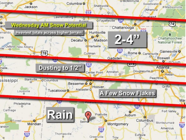
Dynamic cooling associated with the upper low, and cold air advection on the back side of the departing surface low will mean rain changing to snow after midnight tonight over the northern counties of Alabama. The 00/06Z model runs have come in just a little drier, and I have adjusted the accumulation forecast potential slightly…
IMPORTANT POINTS…
*The heaviest snow amounts should be north of U.S. 278…
*For the I-20 corridor (Birmingham, Tuscaloosa, Anniston), some snow is likely, but surface temperatures are not expected to drop below freezing, and the roads should be mostly wet with no serious travel problems. A little snow accumulation is possible on grassy areas.
*For Gadsden, you might see 2 inches of snow (or more across higher terrain north of town), but again, most of it will be on grass and the roads should be generally wet. Perhaps a few icy spots on bridges, but this will be nothing like the big storm of two weeks ago.
*The higher accumulation should be across higher terrain, especially for elevations above 1,000 feet.
*The best chance of snow will come from 2:00 a.m. until 9:00 a.m. tomorrow.
*Where the snow does accumulate, it won’t last long. We will rise into the low 40s tomorrow afternoon after the snow has ended, followed by upper 40s Thursday, and 50s on Friday. No deep freeze this time.
*Our skill is limited in forecasting snow amounts with this kind of setup… so I can almost guarantee you there will be surprises. Stay tuned.
REST OF THE WEEK INTO THE WEEKEND: Look for some really nice weather Thursday through Sunday. We will hit the 50s Friday, and the 00Z GFS is now printing 60 for Saturday. We won’t go quite that warm just yet… but 50s are a lock. The weekend should feature a partly to mostly sunny sky with dry air holding in place.
NEXT WEEK: Our Ground Hog’s Day storm is still on the board… the 06Z GFS is still advertising the next potential for winter weather mischief in Alabama around the middle part of next week… about 8 days away. See the Weather Xtreme video for details.
WEATHER BRAINS: Don’t forget you can listen to our weekly 30 minute netcast anytime on the web, or on iTunes. This is the show all about weather featuring many familiar voices, including our meteorologists here at ABC 33/40. Scroll down for the show notes on the new episode we recorded last night.
FOLLOW ALONG: Here are our weather team Twitter accounts….
| James Spann | Jason Simpson | Ashley Brand |
| J. B. Elliott | Bill Murray | Brian Peters |
| Dr. Tim Coleman | WeatherBrains Podcast | E-Warn (AL wx watches/warnings) |
I have a weather program today at Brookwood Forest Elementary School in Mountain Brook… look for the next full discussion and video by 3:30, but we will post updates throughout the day…
Category: Alabama's Weather


