Two Rounds Of Storms Later This Week
**No afternoon Weather Xtreme video today. I attended the funeral of Bill Murray’s son this afternoon. Please keep the Murray family in your prayers**
ACTIVE WEATHER THIS WEEK: Nothing on the radar this afternoon… and we should remain dry tonight, although low clouds will form again along with the risk of some fog and drizzle.
TOMORROW/WEDNESDAY: The NAM develops a few showers across the state tomorrow afternoon as moisture levels continue to rise… the day will feature more clouds than sun, and the high should be around 70 degrees as the warm-up continues. To the west, severe storms should form by mid to late afternoon, with the higher severe weather probabilities over Arkansas…
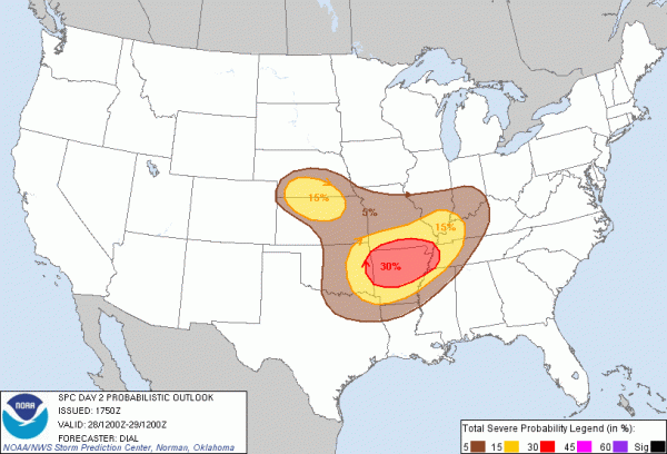
The system responsible for the severe weather to the west tomorrow will move northeast, toward the Great Lakes. The trailing cold front will bring a chance of strong to severe storms across Alabama mainly late Wednesday and Wednesday night. The main risk will come from strong, gusty winds and some hail with the storms along the squall line… the tornado threat still seems to be rather low. Below is the SPC severe weather risk for Wednesday and Wednesday night…
The front will ease down into South-Central Alabama by early Thursday morning, and much of the day Thursday here looks dry. Still very mild; the GFS is now printing a high of 77 for Birmingham on Thursday.
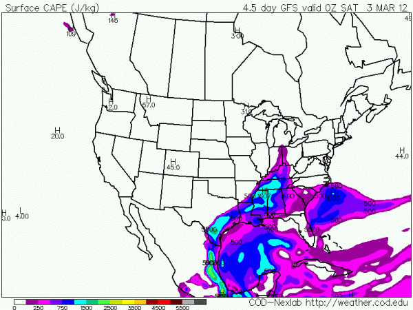
FRIDAY/SATURDAY: The next event comes Friday afternoon and Friday night… and maybe even into early Saturday morning. Below is the forecast instability (surface based CAPE) valid at 6:00 p.m. Friday…
This hints there will be a good bit of surface based instability for storms Friday night, and needless to say there could very well be another severe weather risk. Way too early to be specific about the modes of severe weather… we need to get the Wednesday night system on by, and then we can focus on Friday night.
We also note the 12Z GFS is a little slower with this system, suggesting the storms could linger into Saturday morning. We will need to adjust the forecast a bit if this trend continues.
SUNDAY: Still looks good… with ample sunshine and a high in the low 60s.
See the morning Weather Xtreme video for long range ideas and details….
STORM ALERT 2012: We will bring our severe weather awareness show to Cullman tomorrow night… we will be at the Cullman Civic Center at 6:30; be sure and come early to get a good seat. You will see some very powerful stories about last year’s generational tornado outbreak on April 27.
WEATHER BRAINS: Don’t forget you can listen to our weekly 90 minute netcast anytime on the web, or on iTunes. This is the show all about weather featuring many familiar voices, including our meteorologists here at ABC 33/40. Gary Carter, director of the National Water Center that will be built in Tuscaloosa, will be joining us. You can listen live via uStream here.
CONNECT: You can find me on all of the major social networks…
Look for the next Weather Xtreme video here by 7:00 a.m. tomorrow…
Category: Alabama's Weather


