Severe Weather Alerts to Our West
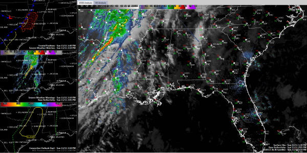
Thunderstorms have broken out no this Sunday, as expected, over the Arklatex. A line of storms showing some broekn supercell tendencies extends from Tyler, TX to north of Texarkana, AR/TX.
There is one small severe thunderstorm warning in southwestern Arkansas for a storm southwest of Arkadelphia. On the inset map in the middle left of the graphic, the SimuAWIPS system shows the counties affected by the warning that goes until 2:30.
The SPC has much of Arkansas, southeastern Oklahoma, northeastern Texas and northwestern Louisiana in their standard risk forecast for severe storms overnight. There is decent low level shear just ahead of the line. so there is a tornado watch in effect until 8 p.m. CST for the counties in red in the lower left hand side graphic. Click on the image to enlarge it, as always in your browser.
You can see the front in the top left graphic, extending from northwestern Arkansas into northeastern Texas. That inset also shows the slight risk severe weather outlook issued by the SPC.
It is quite windy over Alabama. Winds are averaging 10-20 mph and gusting to 25-30 mph at times. With all the leaves lying around, the wind is making quite a racket! Temperatures range from 68F at Anniston to 74F at Tuscaloosa. There is more sunshine on the western side of the state as there is a thick patch of clouds over eastern sections. it will push into Georgia shortly. But clouds will thicken overnight across the entire areas as temperatures fall back into themiddle and upper 50s.
The line of showers and storms will reach northwestern Alabama around 7 a.m. and showers and some thunder will continue to push into western sections of the state all morning. But the entire line should be weakening as it enters the state so no severe weather is expected. Can’t rule out a warning or two as you know, because we always expect the unexpected, but no major problems are anticipated. Showers and some thunder is likely tomorrow mainly during the morning, ending from the west by afternoon.
Expect about one half inch of rain with this system on average.
Highs tomorrow will come in the early morning as temperatures fall behind the front. Readings will be in the lower 50s by afternoon over the I-59 corridor and pointts northwest with fall temps to the southeast as well as the front goes by.
Category: Alabama's Weather, Severe Weather


