

Tuscaloosa Reports/Birmingham Timing
Winds did gust to 56 mph at our SkyCam in Tuscaloosa as the line went through there around 8:15.
Winds to 50 mph were estimated on the UA Campus.
There was a report of a possible funnel cloud on Twitter in Northport. It could have been scud clouds, or it could have been a small spin up gustnado. With the strong winds swirling today, you may see all kinds of fast moving clouds.
No damage was reported.
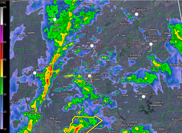
The line of showers is over western Jefferson County. It will reach downtown Birmingham around 9 a.m. It will reach western Shelby County shortly before 9 a.m. as well, and I-65 around 9:15. Be prepared for strong gusty winds.
Further south, Severe Thunderstorm Warning continues for Autauga and Dallas Counties till 8:45 AM CST. Dangerous looking storm passing just north of Selma, lifting into Autauga County.
Category: Alabama's Weather, Severe Weather
About the Author (Author Profile)
Bill Murray is the President of The Weather Factory. He is the site's official weather historian and a weekend forecaster. He also anchors the site's severe weather coverage. Bill Murray is the proud holder of National Weather Association Digital Seal #0001 @wxhistorianSubscribe
If you enjoyed this article, subscribe to receive more just like it.


