

10:30 Update
Click image to expand.
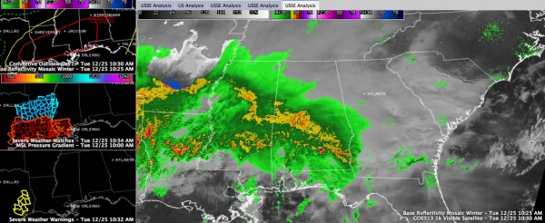
A large area of rain and storms is lifting northward across Central Alabama this morning ahead of a warm front.
The solid mass of precipitation extends from Pickens, Sumter and Greene Counties on the western border of the state through the Brent, Greensboro, Marion, White Hall, Fort Deposit, Brundidge, Ozark and Dothan areas.
There is a good bit of lightning and thunder in the area of rain and storms as well. The storms are elevated, meaning their bases are not rooted near the surface. Generally, it is hard to get severe weather with these storms since the airmass ahead of the front is relatively stable, but we are monitoring them.
The rain/storm mass is moving north at 35 mph. It will be in Shelby County by a little after 10 a.m., Bessemer by 10:15 and downtown Birmingham around 11 a.m. The area is about 50 miles wide, so it will rain for 90 minutes or so. Rainfall rates are running between one quarter and one half inch per hour, so most everyone should get one half to one inch of rain from these initial storms.
Our developing low is just west of Galveston at this hour. Very rich dewpoints above 65F extend all along the Gulf coast all the way from Houston to Panama City. This moisture laden air is ready to be lifted northward.
Thunderstorms are becoming severe in the warm sector south of the warm front. Nearly all of Louisiana is under a severe weather watch now, including a severe thunderstorm watch in the north and tornado watch in the south. The tornado watches extend into southeastern Texas. Tornado and severe thunderstorm warnings are in effect for storms over eastern Texas where intense storms have formed in the vicinity of the upper trough.
Dense fog covers much of Central Alabama ahead of the rain area, especially near and east of I-65. The visibility was 1 1/4 miles at the Shelby County Airport and 2 miles at the Birmingham Airport at last report. Visibilities will improve when the heavy rain arrives.
Temperatures are around 50F ahead of the warm front, with 60s behind the front to near 70F around Mobile. Skies are clearing across southern Louisiana, Mississippi and southwestern Alabama. This will allow the atmosphere to destabilize ever further this afternoon under a bit of a capping inversion. As the stronger lift associated with the upper level features moves over it later today, supercell storms will form and lift northeast.
The slight and moderate risk area was just updated with little change by the SPC. There was some discussion about an upgrade to high risk in parts of the moderate risk area. It will be re-evaluated at 2 p.m. in their next issuance.
This is a potentially very dangerous severe weather situation. All Alabamians should pay close attention to forecasts, watches and warnings through the day and overnight. Review your severe weather safety plans and make sure that you have access to receiving severe weather warnings immediately.
Category: Alabama's Weather, Severe Weather
About the Author (Author Profile)
Bill Murray is the President of The Weather Factory. He is the site's official weather historian and a weekend forecaster. He also anchors the site's severe weather coverage. Bill Murray is the proud holder of National Weather Association Digital Seal #0001 @wxhistorianSubscribe
If you enjoyed this article, subscribe to receive more just like it.


