

Early Sunday Morning Notes
Brian will be along shortly with a full discussion and Weather Xtreme video.
COLD AIR KNOCKING ON THE DOOR: Not too hard to find our front this morning. 70 at Tuscaloosa; 43 at Memphis…
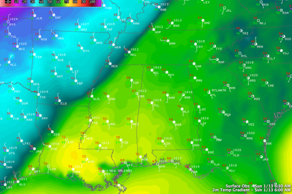
The cold air will spill into Northwest Alabama later today, where temperatures will fall from the 60s this morning into the 40s this afternoon.
SEVERE WEATHER? Despite the big thermal drop, for now the risk of organized severe weather looks small. While there will be some degree of instability, lapse rates and helicity values look very marginal. Still, anytime you go from the 70s into the 40s quickly in January you have to watch the radar closely just in case.
COLD AND WET: Unfortunately we are still looking at a rather long duration rain event in the cold air for the first half of the week ahead… the RPM model is hinting at some 3 to 4 inch rain totals through Thursday…
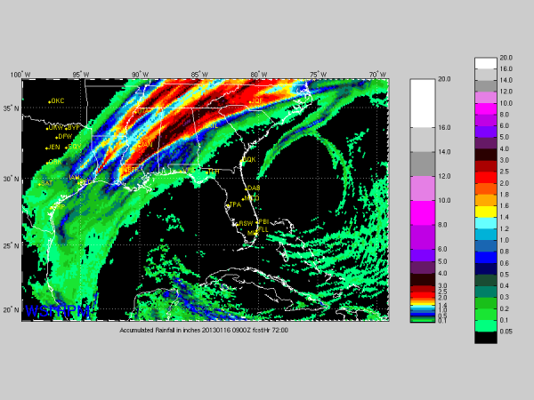
It will be miserable kind of rain with temperatures basically holding in the 40s day and night. We will have to watch for some flooding issues, but major, flash flooding with this kind of stratiform rain event generally isn’t expected.
One more note… there could be a small window for some freezing rain over the northwest corner of Alabama
Category: Alabama's Weather
About the Author (Author Profile)
James Spann is one of the most recognized and trusted television meteorologists in the industry. He holds the AMS CCM designation and television seals from the AMS and NWA. He is a past winner of the Broadcast Meteorologist of the Year from both professional organizations.Subscribe
If you enjoyed this article, subscribe to receive more just like it.


