

9:30 Notes
Snow is really increasing over northwestern Alabama at this hour. It is coming down hard over parts of Winston, Walker, Marion, western Cullman and Morgan Counties back into the Shoals.
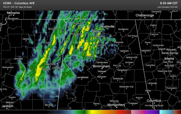
Here is the Columbus radar. The yellow bands are heavier snow, while the green is lighter.
Just saw report of heavy snow falling in Guin with roads slick and slushy. Roads getting bad in Winston County as well, which jives well with the radar.
Further south, light to moderate snow is falling across Lamar, Fayette and Pickens County. Bryan Falls relayed a report of 1 inch on the ground in Berry and says law enforcement is reporting that roads are “bad”. Multiple wrecks are reported.
From Lamar County EMA:
THE FOLLOWING MESSAGE IS TRANSMITTED AT THE REQUEST OF THE LAMAR
COUNTY EMERGENCY MANAGEMENT AGENCY IN ALABAMA:
DUE TO HEAVY SNOWFALL OVER THE LAST COUPLE OF HOURS…ROAD
CONDITIONS HAVE DETERIORATED CONSIDERABLY CAUSING MULTIPLE TRAFFIC
ACCIDENTS. PLEASE…UNLESS YOU ARE DEALING WITH AN EMERGENCY
SITUATION…STAY OFF COUNTY ROADWAYS UNTIL LATER THIS EVENING.
Alabama EMA reports bridges and roads “icing” in Pickens County. Since temperatures are above freezing, they probably are more snow covered or slushy than “icy”, but the point is to be extra cautious or avoid bridges that are snow covered.
To the east, light rain and sleet has developed out over east side of metro Birmingham, moving eastward through St, Clair and Talladega counties. rain and some sleet, accompanied by gusty winds. Wind advisories are in effect for today.
Here is a look at the Birmingham radar.
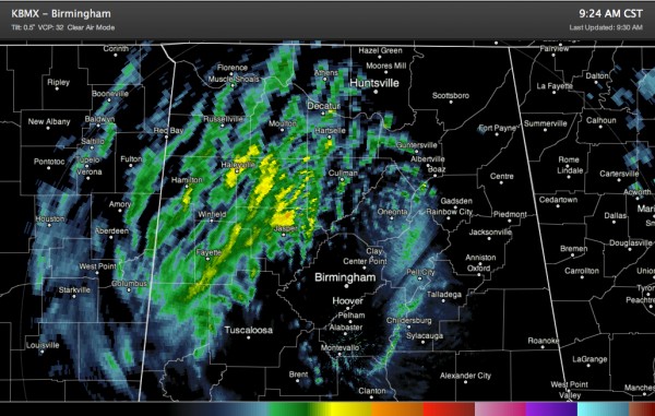
The Columbus radar won’t see the echoes over Birmingham very well and the Birmingham radar won’t see the Mississippi echoes very well, so we are having watch them both closely this morning.
FROM MISSISSIPPI
Officially 1.7 inches of snow at the Jackson International Airport in Jackson MS, setting a new snowfall record for the date.
From our friend Alan Gerard at the NWS Jackson:
Just FYI, we are getting reports of very hazardous conditions in MS now along US Highway 82 from Starkville to Winona. Poor visibilities and slushy/icy roads. Numerous traffic accidents reported in that area.
Local Storm Report by NWS JAN: Mathiston [Webster Co, MS] trained spotter reports HEAVY SNOW of E2.5 INCH at 09:05 AM CST — very hazardous conditions along us highway 82 from Eupora eastward to the Oktibbeha county line. roads covered by snow and becoming icy. multiple traffic accidents. This snwo is about to pass through Starkville. It will reach Marion, Lamar and Pickens Counties
All this is coming our way in Alabama!
Category: Alabama's Weather, Winter Weather
About the Author (Author Profile)
Bill Murray is the President of The Weather Factory. He is the site's official weather historian and a weekend forecaster. He also anchors the site's severe weather coverage. Bill Murray is the proud holder of National Weather Association Digital Seal #0001 @wxhistorianSubscribe
If you enjoyed this article, subscribe to receive more just like it.


