

Heavy Band of Snow Approaching Birmingham
We just talked about thunder with the snow in southern Tennessee, and now it is happening in Central Alabama.
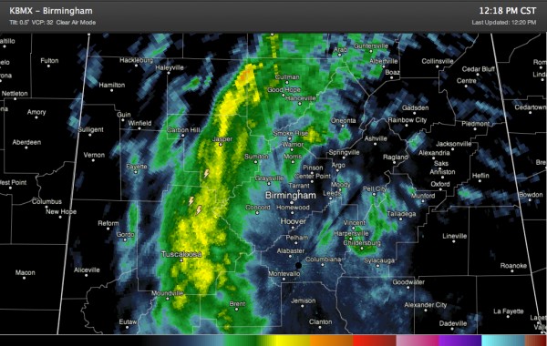
Three lightning strikes have showed up over northeastern Tuscaloosa and southern Walker Counties in the past few minutes. They are northeast of Samantha.
They are in a developing convective band of snow that is set up now from western Cullman and southeastern Winston County west of Cullman across Walker County near Jasper, into the eastern half of Tuscaloosa County from the City of Tuscaloosa eastward. It extends on into northern Bibb County.
It is rotating southeast and will affect much of the Birmingham Metro area.
The band will be accompanied by a burst of heavy snow that could dump 1 to 2 inches of snow per hour. Snowfall rates like that can overcome the relatively warm ground conditions and allow the snow to stick on roads, and especially bridges and overpasses. This will make them slushy and slippery.
It looks like the heaviest snow will track across northeastern Tuscaloosa County, around Brookwood, Vance, Coaling and Lake View, into northern Bibb around West Blocton, southwestern Jefferson County around Tannehill up to Hueytown and North Johns and into western Shelby County around Alabaster and Montevallo.
Everything has been melting in the greater Birmingham area so far as it fell because there just hasn’t been the volume of snow required to make that happen. That’s about to change with this band I think.
Category: Alabama's Weather, Winter Weather
About the Author (Author Profile)
Bill Murray is the President of The Weather Factory. He is the site's official weather historian and a weekend forecaster. He also anchors the site's severe weather coverage. Bill Murray is the proud holder of National Weather Association Digital Seal #0001 @wxhistorianSubscribe
If you enjoyed this article, subscribe to receive more just like it.


