

A Look At The Alabama Weather Situation
Things are fairly quiet across the great state of Alabama tonight. All reporting stations are well above freezing; Coldest spot is Decatur at 36… Birmingham reports 49.
Colder air will continue to advect into North Alabama overnight, and there is still some potential for a period of freezing rain early tomorrow morning.
Below is the latest RPM model, valid at 7:30 a.m. CST… the pink indicates freezing rain….
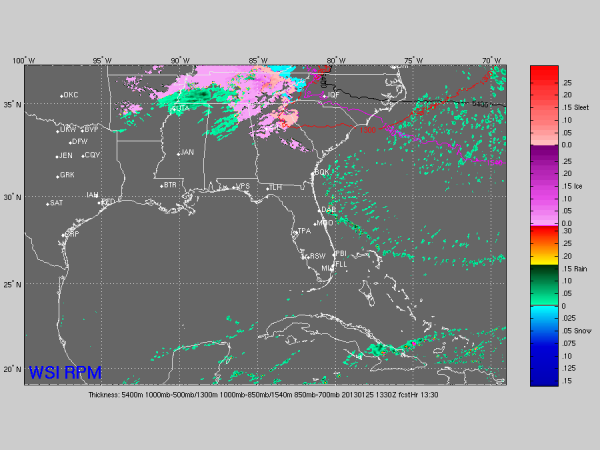
The good news is that temperatures generally are above levels forecast by models so far. But, the CAD (cold air damming) effect should send colder air into the northeast counties of the state after midnight.
I honestly think the main threat of bridge icing tomorrow will be over Jackson, Marshall, DeKalb, Cherokee, Etowah, Calhoun, Cleburne, and Randolph Counties. I know other counties are in the NWS freezing rain advisory, but the greatest chance of 32 degree surface temperatures will be in these eight counties.
The only issue is the potential for icy spots on bridges and overpasses. The freezing rain won’t be heavy enough for really serious ice accumulations. And, we do not expect freezing temperatures for Birmingham, Tuscaloosa, and West Alabama.
Where surface temperatures go below freezing, they should rise above 32 by mid-morning.
Category: Alabama's Weather
About the Author (Author Profile)
James Spann is one of the most recognized and trusted television meteorologists in the industry. He holds the AMS CCM designation and television seals from the AMS and NWA. He is a past winner of the Broadcast Meteorologist of the Year from both professional organizations.Subscribe
If you enjoyed this article, subscribe to receive more just like it.


