

Late Evening Look
Here is a late evening look at our developing severe weather situation.
As the high resolution models have been hinting since this afternoon, the advance storms over Mississippi are being overtaken by the main squall line late tonight.
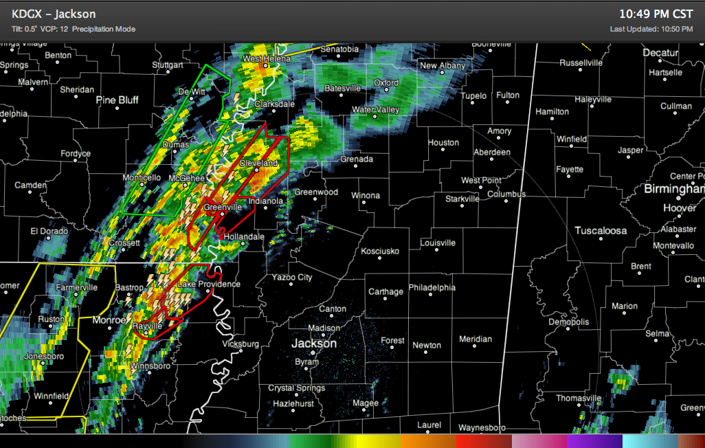
You can see this on the radar image above.
The merged line will accelerate eastward across Mississippi, reaching the Columbus area around 4-5 a.m. and moving into Marion County, Lamar and Pickens Counties between 4:30 and 5:30.
Then, it slows over West Alabama, with the main line reaching from Jasper to Tuscaloosa by around 6 a.m.
Then it looks like one of two things could happen. It could continue pushing eastward as a strong line of storms with a good chance of damaging winds, reaching Birmingham around 7-7:30.
Or there is a chance that it could lose intensity and expand into a wider mass of rain and thunderstorms in the I-59 corridor for most of the morning. This could reduce the severe weather threat.
We will be watching the situation carefully. Expect another update around 1:30 with frequent updates as the storms near West Alabama.
For now, there are several tornado warnings in the Delta of Northeast Louisiana and western Mississippi. A dangerous storm is passing just north of Greenville MS. It shows 70 knot gate to gat shear on Doppler radar.
A tornado watch has just been issued for western Tennessee and much of Mississippi. It goes until 4 a.m. The draft of the watch clipped the northwestern corner of Alabama, but a decision was made to keep any Alabama counties out of the watch.
But you can look for a watch to be issued for Alabama sometime around 3-4 a.m. and expect warnings into West Central Alabama as early as 4-4:30.
Please have a way to hear warnings that will wake you up if you are in West Alabama counties like Pickens, Lamar and Marion, or be up before the storms start arriving.
Northward over Tennessee, widespread damaging winds look to be a threat with the really high winds aloft.
There is an unbroken patchwork of severe thunderstorm warnings from just southwest of Terre Haute IN to Tunica MS!
It is very windy already, and going to get windier across Central Alabama overnight, with gusts to 35 mph over the entire area and occasionally as high as 50 mph along higher ridges.
Category: Alabama's Weather, Met 101/Weather History
About the Author (Author Profile)
Bill Murray is the President of The Weather Factory. He is the site's official weather historian and a weekend forecaster. He also anchors the site's severe weather coverage. Bill Murray is the proud holder of National Weather Association Digital Seal #0001 @wxhistorianSubscribe
If you enjoyed this article, subscribe to receive more just like it.


