

Tornado Watch Coming for Alabama Shortly
Indeed, we have a single line of strong thunderstorms pushing east across western Tennessee and Mississippi at this hour.
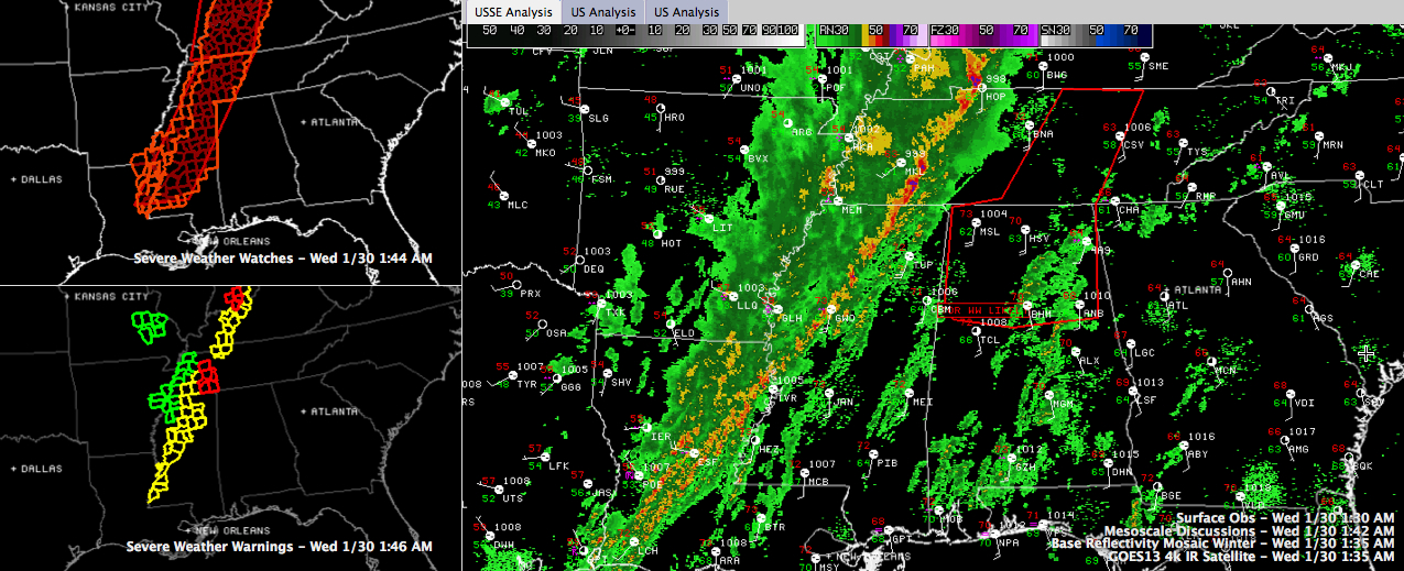
There are several severe thunderstorm warnings in effect from Central Indiana through western Kentucku, western Mississippi and into eastern Louisiana along and ahead of the line. The good news is that there are now several breaks in the chain of warnings, indicating some loss of intensity.
But it is still packing a punch along portions of it. Many of the segments along the line have been showing bowing tendencies, an indication of the threat of high winds. There are very intense winds aloft associated with a strong upper trough, and the winds are screaming a short distance off the surface. At the Columbus AFB, the Doppler radar shows winds of over 80 mph just 3,000 feet off the surface! This indicates the continued high potential for wind damage.
The line has recently intensified lately is over northern Mississippi. There are two tornado warnings, both in northern Mississippi, for two cells near Holly Springs. One is north of the town, the other southwest of it. If you have driven to Memphis on US-78, you know it well. A tornado was reported by at trained spotter at 12:40 near Sardis.
The low level shear is very high, running over 500 m2/s2 on the 0-1 km storm relative heliciy over northern Mississippi and northern Alabama. So the potential is still high for there to be rotation and possible tornadoes. The SPC is currently coordinating a new tornado watch that will include much of the northern half of Alabama and middle Tennessee.
The storms are very low topped, with echo tops running 30,000 feet at most. In fact, looking from the Columbus radar, the line seems to disappear south of Greenwood. But the Jackson radar shows it continuing on into Louisiana. So there is not much lightning with the cells.
There are several flash flood warnings as well, including one large one for several counties in western Tennessee and northwestern Mississippi. Flooding is severe in the Memphis area. Memphis Fire and PD are reportedly flooded with rescue calls according to ABC24. I am sure no pun was intended. Flooding was reported at Poplar and International Place. Just saw a report of flooding near Germantown at Whitewater Road (aptly named) and Wilbec Road.
TIMING
The line now extends from near Jackson, Tennessee to Holy Springs to Batesville to just west of Greenwood to west of Vicksburg. This is some 75 miles west of the Marion County border and 90 miles west of the Lamar County border. By my calculations, the eastward progress is about 30 mph. This will put it into these counties around 3:30 and 4:30 respectively.
Extrapolating further eastward, the line would reach Jasper-Tuscaloosa around 5:30 to 6:00 and Birmingham around 6:30 to 7.
There is some chance that the line will slow down as it approaches western Alabama. The RPM shows it into Marion County around 6:30. It also shows
Category: Alabama's Weather, Severe Weather
About the Author (Author Profile)
Bill Murray is the President of The Weather Factory. He is the site's official weather historian and a weekend forecaster. He also anchors the site's severe weather coverage. Bill Murray is the proud holder of National Weather Association Digital Seal #0001 @wxhistorianSubscribe
If you enjoyed this article, subscribe to receive more just like it.


