

A Great Looking Afternoon
If you are out and about today, you have noticed how great the weather is across Central Alabama. Mostly sunny, dry, temperatures approaching 70 and a light winds. A beautiful early spring day is what we are all seeing today and this will hold true tomorrow as well. Dry weather will last for the rest of today and should last through tomorrow before our next storm system moves in late Sunday night, which means we will probably wake up to the showers and thunderstorms for Monday.
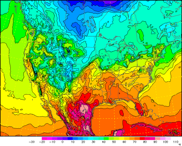
Temperatures across the country are really not that bad. Warms air is in place across much of the east, even places in New England that saw over a foot of snow a couple of days ago are seeing temperatures into the 50s this afternoon. 70s are stretching as far north as Missouri and Kansas. Areas across the Midwest and Northern Plains are in the 20s and 30s, which is not to bad for this time of year. No brutally cold weather in the continental U.S.
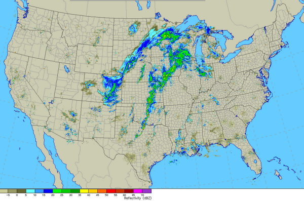
A quick look at the national radar shows a line of thunderstorms along the Interstate 35 corridor. Some storms are severe and there is a severe thunderstorm watch that does include the Dallas/Ft. Worth Metroplex. That line of storms will continue to move east overnight and should be impacting the Lower Mississippi River Valley tomorrow. These storms will loose some of their punch and organized severe weather is not expected in the region tomorrow. The precip in the Central Plains and Midwest is snow. Blizzard warnings are in place across the west central Plains and sections of South Dakota and Minnesota could see up to to half a foot of snow.
Category: Alabama's Weather
About the Author (Author Profile)
Macon, Georgia Television Chief Meteorologist, Birmingham native, and long time Contributor on AlabamaWX. Stormchaser. I did not choose Weather, it chose Me. College Football Fanatic. @Ryan_StinnetSubscribe
If you enjoyed this article, subscribe to receive more just like it.


