

Large Hail/High Wind Threat Continues
**No afternoon Weather Xtreme video due to ongoing severe weather issues**
SEVERE THUNDERSTORM WATCH UNTIL 9:00 p.m: Doesn’t really matter where you live, all of North and Central Alabama will have to deal with storms over the next several hours.
As stated here earlier, the main threats are large hail and damaging wind… see the hail earlier this afternoon that came down at Hackleburg (photo from @bigcountry0915)

Also getting some reports of wind damage and power lines down in Marion County around Hamilton as I write this.
Here is the radar at 2:15pm…
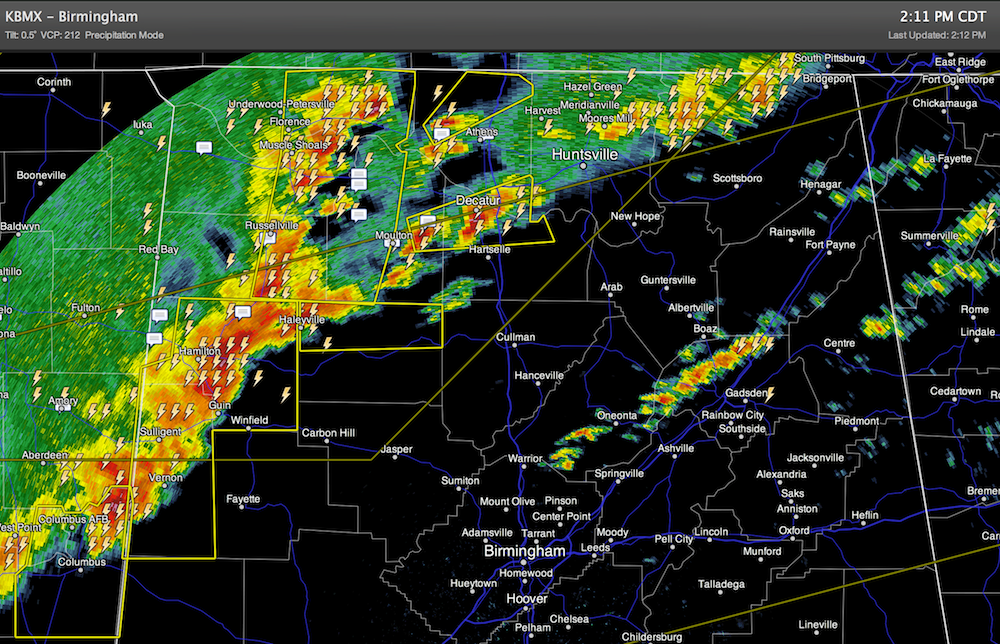
The line of storms will move steadily to the southeast for the rest of the afternoon. While a storm could pop up an ANY time (strong storms are now in progress over East Alabama well ahead of the line)… the main band will arrive in these places (approximate times)…
Jasper/Cullman 2:45-3:15
Tuscaloosa/Birmingham 3:15-3:45
Anniston/Gadsden 3:45-4:15
ALL of Alabama will be impacted by showers and storms over the next 6-8 hours. No need to ask about a specific county… everybody gets wet.
The storms in the line are capable of producing hail stones to the size of golf balls, and winds that can gust higher than 50 mph. All counties ahead of the line are under severe thunderstorm warnings.
The tornado threat, while not zero, is small.
The rain will end from west to east tonight as cooler air moves in.
REST OF THE WEEK: The weather looks cool and dry tomorrow through Thursday. A good chance we see a light freeze early Thursday morning. Rain moves back into the state Friday.
WET WEEKEND: For now the weekend looks wet with periods of rain both Saturday and Sunday. There will be some breaks in the rain, but it could rain at any time both days. We will struggle to reach the low 60s over the weekend due to clouds and rain. And, on Sunday, some evidence of a cold core upper low moving overhead, and you know the issues those can bring. More on this tomorrow morning.
And, next week looks pretty cold for late March with potential for at least one or two mornings will sub-freezing temperatures.
WEATHER BRAINS: Don’t forget you can listen to our weekly 90 minute netcast anytime on the web, or on iTunes. This is the show all about weather featuring many familiar voices, including our meteorologists here at ABC 33/40. We will produce this week’s show tomorrow night at 8:30 p.m. CDT.
CONNECT: You can find me on all of the major social networks…
Look for frequent updates through the evening…
Category: Alabama's Weather
About the Author (Author Profile)
James Spann is one of the most recognized and trusted television meteorologists in the industry. He holds the AMS CCM designation and television seals from the AMS and NWA. He is a past winner of the Broadcast Meteorologist of the Year from both professional organizations.Subscribe
If you enjoyed this article, subscribe to receive more just like it.


