

Tornado Warning Lee/Macon/Tallapoosa until 9:15 PM

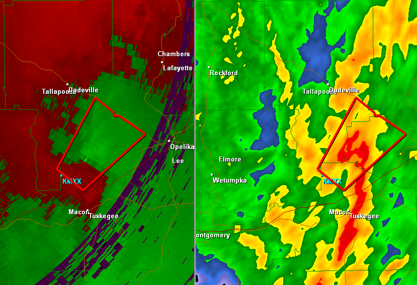
A tornado is being reported on the ground with this storm as the correlation coefficient of radar is detecting debris aloft with this storm. The storm is moving to the northeast at 35 mph. The storm will clip portions of Macon and Tallapoosa County but should mostly impact Lee County. Areas west, north and near Auburn University will be impacted by this storm. The town of Loachapoka and areas along Wire Road are in the path of this storm as well as areas along U.S. Highway 280 between Opelika and Dadeville.
THE NATIONAL WEATHER SERVICE IN BIRMINGHAM HAS ISSUED A
* TORNADO WARNING FOR…
NORTHWESTERN LEE COUNTY IN EAST CENTRAL ALABAMA…
NORTH CENTRAL MACON COUNTY IN SOUTHEAST ALABAMA…
SOUTHEASTERN TALLAPOOSA COUNTY IN EAST CENTRAL ALABAMA…
* UNTIL 915 PM CDT
* AT 842 PM CDT…THE NATIONAL WEATHER SERVICE INDICATED A SEVERE
THUNDERSTORM CAPABLE OF PRODUCING A TORNADO. THIS DANGEROUS STORM
WAS LOCATED NEAR NOTASULGA…AND MOVING NORTHEAST AT 35 MPH.
* LOCATIONS IMPACTED INCLUDE…
LOACHAPOKA AND ROXANA.
PRECAUTIONARY/PREPAREDNESS ACTIONS…
TAKE COVER NOW. FOR YOUR PROTECTION MOVE TO AN INTERIOR ROOM ON THE
LOWEST FLOOR OF A STURDY BUILDING.
Category: Alabama's Weather, Severe Weather
About the Author (Author Profile)
Subscribe
If you enjoyed this article, subscribe to receive more just like it.


