

El Reno, OK Tornado Rated EF-5
Info from NWS, Norman, OK on the EF-5 rating assigned today to the El Reno tornado…
FACTS
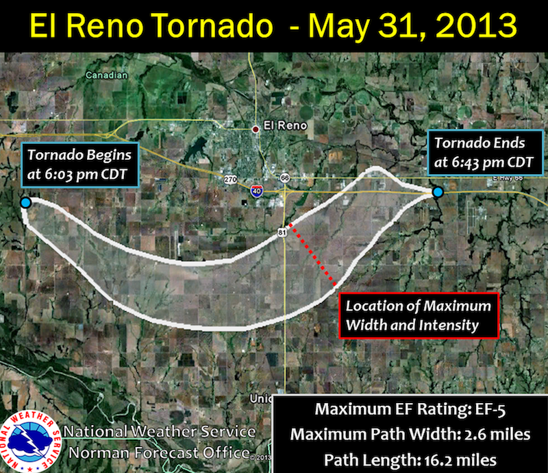
• El Reno Tornado
• May 31, 2013
• Time: 6:03 PM – 6:43 PM CDT • Path Length: 16.2 miles
• Maximum Width: 2.6 miles
• Maximum EF-Scale: EF5
MAXIMUM WIDTH
• The tornado was at least 2.6 miles wide.This is likely conservative.
• Damage indicators were sparse, so it was difficult to estimate the maximum width of the tornado based on the ground survey.
• However, we were able to use mobile Doppler radar velocity data to estimate the path width.
• We used a Doppler radar radial velocity of 65 mph – corresponding to the threshold of EF0 tornadic winds – to help estimate the tornado width.
MAXIMUM INTENSITY
• The tornado struck mostly rural areas of Canadian County, leading to difficulty establishing maximum intensity.
• Initial estimate of EF3 was based on damage to several structures, but the inferred tornado intensity was an underestimate of tornado strength because of the scarcity of damage indicators and very small regions of extreme winds.
• However, two high-resolution mobile radars acquired high detail datasets of the tornado.
• The University of Oklahoma’s RaXPol, a rapid-scan, polarimetric, mobile Doppler radar, measured winds greater than 295 mph at several times and locations within 500 feet of the ground along the south side of subvortices on the south side of the tornado.
• These extreme velocities occurred several times in the RaXPol data.
• Extreme winds associated with small, rapidly-translating subvortices within the larger tornadic
circulation.
• These intense subvortices remained over open fields and did not directly affect structures.
• The two most intense subvortices with the highest velocities occurred north and east of the intersection of 10th and Radio Road approximately 3 miles SSE of El Reno.
• The observation of winds well above the EF4/EF5 boundary from two independent rapid-scan mobile radars lends confidence to the observed winds.
• Known damage indicators were compared to RaXPol velocity measurements; good agreement was found between EF-scale rating and velocities above.
Category: Met 101/Weather History
About the Author (Author Profile)
James Spann is one of the most recognized and trusted television meteorologists in the industry. He holds the AMS CCM designation and television seals from the AMS and NWA. He is a past winner of the Broadcast Meteorologist of the Year from both professional organizations.Subscribe
If you enjoyed this article, subscribe to receive more just like it.


