Showers/Storms Through Tomorrow; Drier Friday
An all new edition of the ABC 33/40 Weather Xtreme video is available in the player on the right sidebar of the blog. You can subscribe to the Weather Xtreme video on iTunes by clicking here.
ACTIVE STORMS: Strong summer storms continue in scattered pockets across Alabama this afternoon. Heavier storms at 4:00 this afternoon were south of I-85 in East Alabama… flooding was reported from this band of storms in Auburn earlier. Across North Alabama, scattered strong storms continue as well. All of the showers and storms are moving southeast.
TONIGHT/TOMORROW: We will maintain a good chance of occasional showers and thunderstorms. The high resolution NAM model show a batch of showers and strong storms moving into the Tennessee Valley region of far North Alabama during the pre-dawn hours tomorrow, then moving down toward Birmingham/Tuscaloosa/Anniston/Gadsden between 6 and 10 a.m. And, by afternoon, those storms move down into South Alabama. We will lean in that direction in the forecast, with the best chance of rain and storms coming during the morning hours. A few strong storms are possible tomorrow with gusty winds, but organized severe weather for now is not expected.
FRIDAY/SATURDAY: These two days look rain-free, generally speaking, for the northern half of Alabama. Showers should be confined to the southern counties, and even there the activity will be pretty scattered. The high both days will be in the 86-90 degree range with a pretty good supply of sunshine.
SUNDAY AND NEXT WEEK: We will use the summer “broad brush” forecast… partly sunny days with the risk of “scattered, mostly afternoon and evening showers and thunderstorms. Highs 87-90 degrees, and the chance of any one spot getting wet for the first half of the week is about one in three. This, of course, is under the assumption that tropical weather issues won’t crop up here.
CHANTAL DEGENERATES: Hurricane hunters again today could not find a closed circulation with the system in the Caribbean, and NHC has dropped the advisories for now. With a weak, shallow system, it is very hard to determine what happens next, but the remnant wave could bring some significant rain to Central and South Florida by Friday and Saturday. We will keep an eye on it.
GULF COAST WEATHER: Showers and storms are likely tomorrow afternoon and tomorrow night from Panama City west to Gulf Shores, but the weather will be drier Friday with 7-9 hours of sunshine and only widely scattered showers. For the weekend, the TUTT low in the Gulf will be pretty far to the south, so it looks like fairly routine weather with 6-8 hours of sunshine Saturday and Sunday along with the risk of scattered showers and thunderstorms. Similar weather is likely next week for the coast unless Chantel decides to get her act together. Highs along the immediate coast will hold in the upper 80s, and the sea water temperature at the Dauphin Island Sea Lab this afternoon is a warm 87 degrees.
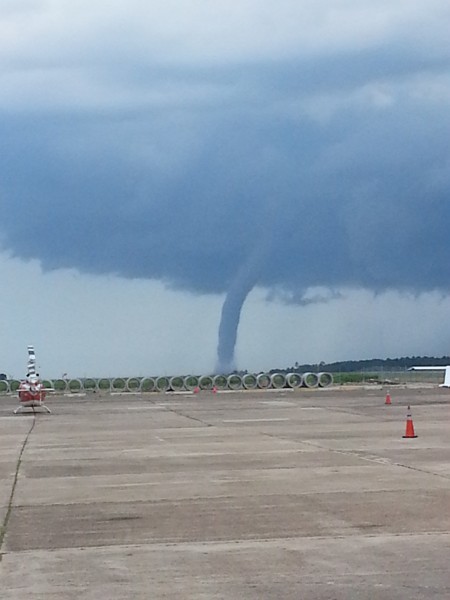
MOBILE BAY WATERSPOUT: A big one formed this afternoon, but did not produce any damage as far as we know. The image below is courtesy of John Theobald, who took the picture just off the runway at Brookley Aeroplex in Mobile.
See the Weather Xtreme video for the maps, graphics, and more details on this discussion.
WEATHER BRAINS: Don’t forget you can listen to our weekly 90 minute netcast anytime on the web, or on iTunes. This is the show all about weather featuring many familiar voices, including our meteorologists here at ABC 33/40.
CONNECT: You can find me on all of the major social networks…
Facebook
Twitter
Google Plus
Instagram
I enjoyed spending some time on the campus of the University of Alabama this morning at a weather seminar… good to see many NWS, TV, and EMA friends there. Look for the next Weather Xtreme video here by 7:00 a.m. tomorrow…
Category: Alabama's Weather


