

Heading into Sunday
Nearly all the convection from today has since dissipated over the last few hours since the sun has set. It should be a fairly nice evening and night across most of Central Alabama, but there still could be a very isolated storm pop up during the overnight hours.
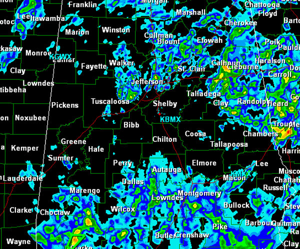
Let’s recap what happened today. As expected, scattered showers and thunderstorm developed across Central Alabama and produced some heavy rainfall where there occurred. Most of the activity was confined to eastern and southern portions of the state, but the Birmingham metro did see several storms as well. Rainfall totals exceeded one inch in portions of Calhoun County as some localized areas in Jefferson and Clay Counties. The map below shows where rainfall did occur across the state. Very little rainfall over western portions of Alabama as well as locations between Birmingham and Montgomery. We can expect to see more colors on the radar tomorrow.
As we head into Sunday, we can expect a very similar situation, but the convection may be a bit more widespread. Clockwise flow around an area of high pressure off the East Coast will continue to allow moisture to stream north across the state from the Gulf of Mexico. A diminishing upper-level low over Louisiana will provide ample uplift, daytime heating will increase instability and it looks as though we can expect an active afternoon. The graphic below is for 1PM tomorrow afternoon and this forecast models shows that widespread showers and thunderstorms should be ongoing. Looking at the forecast period after the one I have included, continued to show more widespread convection would be ongoing across the state; painting a pretty wet picture for our Sunday. Storms will be strong at times, with the greatest threat remaining torrential tropical downpours and frequent lightning. Not expecting severe weather tomorrow, but if storms reach severe limits it will be briefly and they could produce hail and damaging winds. Flash flooding should remain the greatest threat for most areas.
Category: Alabama's Weather
About the Author (Author Profile)
Macon, Georgia Television Chief Meteorologist, Birmingham native, and long time Contributor on AlabamaWX. Stormchaser. I did not choose Weather, it chose Me. College Football Fanatic. @Ryan_StinnetSubscribe
If you enjoyed this article, subscribe to receive more just like it.


