

Heaviest Rain Shifting East, More Showers Later
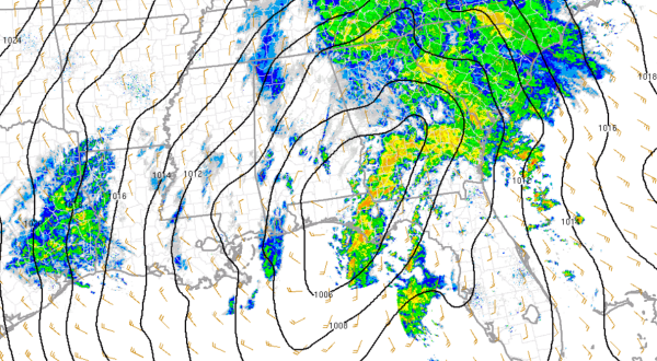
The heaviest of the rain has moved off to the east of Alabama, with only scattered light showers ongoing across the state. There is a surface low pressure along the coast of the Florida Panhandle that continues to draw moisture north from the Gulf of Mexico. As the low shifts east of the state, winds will begin blowing out of the north and that will allow for colder air to move into the state.
The upper-level low with this system is still back in eastern Texas and is the reason there is showers still in that area. This upper level low will be heading our way over the next few hours and will cause additional showers to develop over Mississippi and Alabama this evening. With the cold air settling in, this will set the stage for a wintry mix overnight.
The rain/snow mix should begin across western portions of the state between 9-11 PM and will be crossing the state during the overnight hours. As the temperatures continue to drop we should see a complete switch to an all snow event. The snow should fall for a couple of hours and will fall while most everyone will be a sleep. It is likely to be done snowing by the time the sun comes up in the morning.
There could be some areas of light accumulations, especially on grassy surfaces. The most likely locations for accumulations will be north of Interstate 20 and west of Interstate 65 in northeastern portions of the state. We are not expecting travel problems from accumulations, but as temperatures drop below freezing in the morning, we could see some areas of black ice develop on some of the local roadways.
Category: Alabama's Weather
About the Author (Author Profile)
Macon, Georgia Television Chief Meteorologist, Birmingham native, and long time Contributor on AlabamaWX. Stormchaser. I did not choose Weather, it chose Me. College Football Fanatic. @Ryan_StinnetSubscribe
If you enjoyed this article, subscribe to receive more just like it.


