

Interesting Discussion from the SPC
Regarding the threat for wintry precip across the Southeast this morning. Dry air continues to advect in from the north. This will cause the freezing line to slowly shift south the next few hours. Current freezing line is just to the north of Interstate 20 corridor as it sinks to the south, the rain currently affecting this area will switch over to freezing rain and sleet.
Already seeing road issues in our northern counties and we are expecting to see road conditions to become much worse rapidly in Central Alabama.
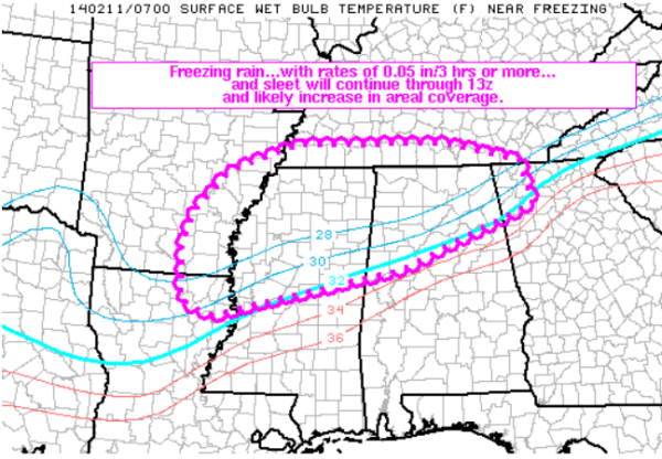
AREAS AFFECTED…PORTIONS OF SERN AR…SRN TN…NERN LA…NRN
MS…NRN AL…NWRN GA
CONCERNING…WINTER MIXED PRECIPITATION
SUMMARY…FREEZING RAIN…WITH RATES OF 0.05 IN/3 HRS OR MORE…AND
SLEET WILL LIKELY CONTINUE AND INCREASE IN AREAL COVERAGE THROUGH
13Z.
DISCUSSION…PRECIPITATION CONTINUES TO INCREASE WITHIN A BROAD
LOW-LEVEL WARM ADVECTION ZONE ACROSS PORTIONS OF THE LOWER MS/TN
VALLEY REGION AS OF 0730Z. LATEST MESOANALYSIS SHOWS THE WET-BULB
FREEZING LINE EXTENDS FROM SOUTH OF MLU EWD ACROSS CENTRAL MS TO
NORTH OF BHM AND ACROSS FAR NWRN GA. N-NELY LOW-LEVEL FLOW WILL
CONTINUE TO ADVECT DRY AIR ACROSS THE DISCUSSION AREA AND ALLOW THE
FREEZING LINE TO CONTINUE SHIFTING SLOWLY SWD. MORE CONCENTRATED
LIFT RESULTING FROM INCREASING FRONTOGENETICAL FORCING IN THE
850-700 MB LAYER WILL LEAD TO HIGHER PRECIPITATION RATES THROUGH
13Z…AND FORECAST SOUNDINGS SUGGEST FREEZING RAIN AND SLEET WILL BE
DOMINANT PRECIP TYPES WITHIN THE DISCUSSION AREA…WITH SNOW ALSO
POSSIBLE ACROSS NRN PORTIONS OF THE DISCUSSION AREA. FREEZING RAIN
RATES IN EXCESS OF 0.05 INCHES/3 HRS WILL BE LIKELY.
Category: Alabama's Weather, Winter Weather
About the Author (Author Profile)
Macon, Georgia Television Chief Meteorologist, Birmingham native, and long time Contributor on AlabamaWX. Stormchaser. I did not choose Weather, it chose Me. College Football Fanatic. @Ryan_StinnetSubscribe
If you enjoyed this article, subscribe to receive more just like it.


